TopoQuest Logo
Do you find TopoQuest useful?
Help keep TopoQuest running and adding new maps/features by donating!
Bitcoin:  19c7KJd3qBynnjoSw5npx9KScwjBe4ifkT
Litecoin:  LXs6TkuXGGXo1vDsWCkWVdjQX94eUKd6ui
Home View Maps Find Maps Find Places Resources & Links


Horseshoe Lake, Arkansas Topographic Map

USGS Map Title: Horseshoe Lake, AR
USGS Map MRC: 34090H3
DRG (GeoTIFF) Download: o34090h3.tif


Neighboring USGS Topographic Map Quads:


  Chatfield, AR  
35090A4
 

  Edmondson, AR  
35090A3
 

  Fletcher Lake, AR  
35090A2
 

  Hughes, AR  
34090H4
 

  Horseshoe Lake, AR  
34090H3
 

  Lake Cormorant, MS  
34090H2
 

  Council, AR  
34090G4
 

  Robinsonville, MS  
34090G3
 

  Banks, MS  
34090G2


Map MRC Location:

N35°
W91°
N35°
W90°
H8 H7 H6 H5 H4 H3 H2 H1
G8 G7 G6 G5 G4 G3 G2 G1
F8 F7 F6 F5 F4 F3 F2 F1
E8 E7 E6 E5 E4 E3 E2 E1
D8 D7 D6 D5 D4 D3 D2 D1
C8 C7 C6 C5 C4 C3 C2 C1
B8 B7 B6 B5 B4 B3 B2 B1
A8 A7 A6 A5 A4 A3 A2 A1
N34°
W91°
N34°
W90°

Horseshoe Lake, AR USGS 1:24K Topographic Map Preview:
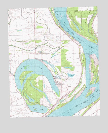
Horseshoe Lake, AR USGS Topographic Map
Click on map above to begin viewing in our Map Viewer.

This topographic map contains these locations and features:
Feature Name Type Latitude Longitude GNIS ID View Map
Allen FarmLocaleN34.9212°W90.2807°76159View Map
Boggy BayouGutN34.9865°W90.3351°46799View Map
Bright Star ChurchChurchN34.9584°W90.3382°67746View Map
Brinkley FarmLocaleN34.8795°W90.3568°76421View Map
BruinsPopulated PlaceN34.8884°W90.3512°67748View Map
Bruins ChapelChurchN34.8782°W90.3270°47033View Map
Bruins LandingLocaleN34.8779°W90.3348°68712View Map
Bruins SchoolSchoolN34.9037°W90.3665°47034View Map
Bushy LakeLakeN34.8958°W90.3464°74724View Map
Camp Kare FreeLocaleN34.9415°W90.3368°47324View Map
Cat Island BendBendN34.8962°W90.2545°690241View Map
Cat Island DikesCanalN34.9520°W90.2695°79119View Map
Cat Island DikesLeveeN34.9373°W90.2654°84398View Map
Cat Island Farm (historical)LocaleN34.9559°W90.2790°47523View Map
Cat Island Number 50IslandN34.9304°W90.2695°81997View Map
Cat Island TowheadIslandN34.9223°W90.2504°47524View Map
Church of Jesus ChristChurchN34.9037°W90.3657°67752View Map
Clarks FarmLocaleN34.9090°W90.3079°47810View Map
Columbia PlantationLocaleN34.9934°W90.3518°47940View Map
Cow Island BendBendN34.9879°W90.2873°690255View Map
Cow Island BendBendN34.9876°W90.3012°1313902View Map
Cow Island Bend RevetmentCanalN34.9798°W90.3018°85272View Map
Cow Island Number Forty-sevenIslandN34.9957°W90.2854°1313903View Map
Cow IslandsIslandN34.9912°W90.2701°690256View Map
Cunningham FarmLocaleN34.9707°W90.3104°48265View Map
Daisy LodgeLocaleN34.9851°W90.3054°48331View Map
Finley BarBarN34.8790°W90.3115°49053View Map
Fish BayouGutN34.9543°W90.3595°49060View Map
Five Lakes ClubLocaleN34.9229°W90.3323°82429View Map
Goat IslandIslandN34.8834°W90.3412°49459View Map
Goose LakeLakeN34.9067°W90.3359°74851View Map
Green River School (historical)SchoolN34.9693°W90.3382°70233View Map
Grey FarmLocaleN34.8773°W90.2695°690287View Map
Happy JackGutN34.9204°W90.3570°49842View Map
Harkleroad TowheadIslandN34.9301°W90.2562°77117View Map
Harris Club (historical)LocaleN34.9201°W90.3132°70234View Map
Horseshoe LakeLakeN34.9254°W90.3401°74912View Map
Horseshoe LakePopulated PlaceN34.9134°W90.3073°1669459View Map
Horseshoe Lake BayouGutN34.8982°W90.3115°50343View Map
Horseshoe Lake ClubLocaleN34.9237°W90.3157°82448View Map
Horseshoe Lake Volunteer Fire DepartmentBuildingN34.9138°W90.3076°2116597View Map
Horseshoe Lake Volunteer Fire Department Station 2BuildingN34.9479°W90.3389°2625417View Map
Irby (historical)Populated PlaceN34.9945°W90.3168°67787View Map
Island Number 47IslandN34.9857°W90.2812°692363View Map
Island Number FortysevenIslandN34.9859°W90.2634°690307View Map
Kate LodgeLocaleN34.9037°W90.2729°50769View Map
Lake DelocheLakeN34.9219°W90.2895°74789View Map
Lake Shore ChurchChurchN34.9482°W90.3412°67789View Map
Locust Grove CemeteryCemeteryN34.9398°W90.2776°67791View Map
Locust Grove ChurchChurchN34.9359°W90.2757°51376View Map
Lost River BayouGutN34.8920°W90.3487°51477View Map
Minoso FarmLocaleN34.9507°W90.3123°52095View Map
Mosley Temple ChurchChurchN34.9762°W90.3379°67803View Map
Mount Zion ChurchChurchN34.9534°W90.3045°52476View Map
Mud LakeGutN34.9159°W90.3540°52519View Map
New Mount Zion CemeteryCemeteryN34.9943°W90.3448°52723View Map
New Mount Zion Church (historical)ChurchN34.9945°W90.3445°77835View Map
Norfolk Star RevetmentLeveeN34.8932°W90.2545°690365View Map
Perryland FarmLocaleN34.8990°W90.3165°77979View Map
PinckneyPopulated PlaceN34.9768°W90.3054°58373View Map
Pinckney LodgeLocaleN34.9654°W90.2843°53403View Map
Porter LakeLakeN34.8847°W90.3360°75084View Map
Rock ChuteStreamN34.9773°W90.2723°690388View Map
Rock ChuteCanalN34.9876°W90.2726°1314042View Map
Rock Point LodgeLocaleN34.9565°W90.2748°54106View Map
Rodgers CemeteryCemeteryN34.9095°W90.2926°54156View Map
Rodgers FarmLocaleN34.9157°W90.3243°54157View Map
Rodgers PlantationLocaleN34.9023°W90.2945°70251View Map
Saint Marys of the Lake ChurchChurchN34.9470°W90.3287°67823View Map
Schultz StoreLocaleN34.9931°W90.3387°54630View Map
SeyppelPopulated PlaceN34.8998°W90.2970°67827View Map
Seyppel LandingLocaleN34.8898°W90.2970°68716View Map
Snowden PlantationLocaleN34.9426°W90.3465°54991View Map
Snowden SchoolSchoolN34.9643°W90.3382°54992View Map
T J LandingLocaleN34.9618°W90.2801°70255View Map
The Allen StacysLocaleN34.9468°W90.2779°55503View Map
Thelma LodgeLocaleN34.9770°W90.3004°55517View Map
Thomas Grove ChurchChurchN34.9479°W90.3370°70256View Map
Thomas Grove School (historical)SchoolN34.9479°W90.3373°70257View Map
Thompson GrovePopulated PlaceN34.9476°W90.3379°67832View Map
Thompson PlantationLocaleN34.9951°W90.3182°78545View Map
Town of Horseshoe LakeCivilN34.9136°W90.3076°2405867View Map
Township of LucasCivilN34.9193°W90.3380°68750View Map
Walnut Grove ChurchChurchN34.8929°W90.3079°56005View Map
Walnut Grove SchoolSchoolN34.8937°W90.3082°56012View Map
Zanones CampLocaleN34.9201°W90.3140°56622View Map

Note: Coordinates in the location and feature list above are referenced to NAD83 datum.


Copyright (C) 2008-2024 Ryan Niemi / Sunset Dynamics ... All Rights Reserved