TopoQuest Logo
Do you find TopoQuest useful?
Help keep TopoQuest running and adding new maps/features by donating!
Bitcoin:  19c7KJd3qBynnjoSw5npx9KScwjBe4ifkT
Litecoin:  LXs6TkuXGGXo1vDsWCkWVdjQX94eUKd6ui
Home View Maps Find Maps Find Places Resources & Links


Cow Creek Ranch, Wyoming Topographic Map

USGS Map Title: Cow Creek Ranch, WY
USGS Map MRC: 41106C7
DRG (GeoTIFF) Download: o41106c7.tif


Neighboring USGS Topographic Map Quads:


  Walck Ranch, WY  
41106D8
 

  Saratoga, WY  
41106D7
 

  Finley Reservoir, WY  
41106D6
 

  Indian Rocks, WY  
41106C8
 

  Cow Creek Ranch, WY  
41106C7
 

  Cow Creek, WY  
41106C6
 

  Red Mountain, WY  
41106B8
 

  Encampment, WY  
41106B7
 

  Gunst Reservoir, WY  
41106B6


Map MRC Location:

N42°
W107°
N42°
W106°
H8 H7 H6 H5 H4 H3 H2 H1
G8 G7 G6 G5 G4 G3 G2 G1
F8 F7 F6 F5 F4 F3 F2 F1
E8 E7 E6 E5 E4 E3 E2 E1
D8 D7 D6 D5 D4 D3 D2 D1
C8 C7 C6 C5 C4 C3 C2 C1
B8 B7 B6 B5 B4 B3 B2 B1
A8 A7 A6 A5 A4 A3 A2 A1
N41°
W107°
N41°
W106°

Cow Creek Ranch, WY USGS 1:24K Topographic Map Preview:
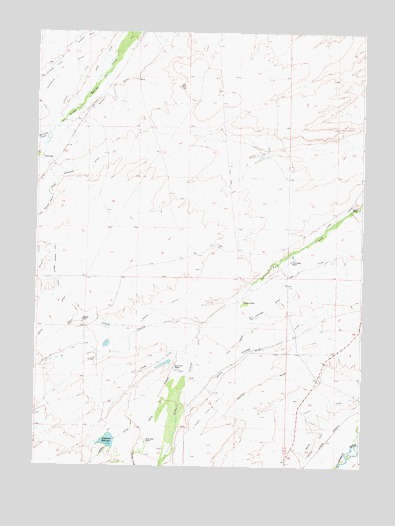
Cow Creek Ranch, WY USGS Topographic Map
Click on map above to begin viewing in our Map Viewer.

This topographic map contains these locations and features:
Feature Name Type Latitude Longitude GNIS ID View Map
Anderson DamDamN41.2583°W106.8439°1605641View Map
Anderson ReservoirReservoirN41.2573°W106.8467°1584832View Map
Calf CreekStreamN41.2916°W106.8106°1598576View Map
Centennial CreekStreamN41.3452°W106.8709°1598687View Map
Centennial DitchCanalN41.3575°W106.8723°1598688View Map
Cow Creek Highland DitchCanalN41.2911°W106.7914°1587111View Map
Cow Creek RanchLocaleN41.2775°W106.8212°1587113View Map
Evans RanchLocaleN41.3250°W106.7517°1588343View Map
Hill RanchLocaleN41.3386°W106.8725°1589569View Map
Huston RanchLocaleN41.2975°W106.7953°1589835View Map
Low DitchCanalN41.3100°W106.7642°1591075View Map
Mcmicken DitchCanalN41.3333°W106.8656°1601319View Map
Nelson DitchCanalN41.3600°W106.8456°1592001View Map
Newport DitchCanalN41.3597°W106.8595°1601691View Map
Old Spring Creek DitchCanalN41.3077°W106.8687°1601913View Map
Otto CreekStreamN41.2875°W106.8125°1601952View Map
Ridge DitchCanalN41.3689°W106.8495°1593450View Map
Saratoga DivisionCivilN41.2921°W106.7932°1939735View Map
Shipper ClaimsMineN41.3547°W106.7500°1726280View Map
Silver Spur RanchLocaleN41.2575°W106.8325°1594352View Map
Tail CreekStreamN41.2886°W106.8367°1603518View Map
Teddy CreekStreamN41.2536°W106.8370°1603543View Map
Trowbridge RanchLocaleN41.3091°W106.7773°1595723View Map
Walck DitchCanalN41.2916°W106.8384°1603957View Map
Waldron DitchCanalN41.2864°W106.7828°1595990View Map
Willford RanchLocaleN41.2914°W106.8567°1596409View Map
Willow DitchCanalN41.2802°W106.7981°1596458View Map
Wolford DitchCanalN41.2741°W106.7870°1596588View Map

Note: Coordinates in the location and feature list above are referenced to NAD83 datum.


Copyright (C) 2008-2024 Ryan Niemi / Sunset Dynamics ... All Rights Reserved