TopoQuest Logo
Do you find TopoQuest useful?
Help keep TopoQuest running and adding new maps/features by donating!
Bitcoin:  19c7KJd3qBynnjoSw5npx9KScwjBe4ifkT
Litecoin:  LXs6TkuXGGXo1vDsWCkWVdjQX94eUKd6ui
Home View Maps Find Maps Find Places Resources & Links


Cranston, Kentucky Topographic Map

USGS Map Title: Cranston, KY
USGS Map MRC: 38083C4
DRG (GeoTIFF) Download: o38083c4.tif


Neighboring USGS Topographic Map Quads:


  Burtonville, KY  
38083D5
 

  Stricklett, KY  
38083D4
 

  Head of Grassy, KY  
38083D3
 

  Plummers Landing, KY  
38083C5
 

  Cranston, KY  
38083C4
 

  Soldier, KY  
38083C3
 

  Farmers, KY  
38083B5
 

  Morehead, KY  
38083B4
 

  Haldeman, KY  
38083B3


Map MRC Location:

N39°
W84°
N39°
W83°
H8 H7 H6 H5 H4 H3 H2 H1
G8 G7 G6 G5 G4 G3 G2 G1
F8 F7 F6 F5 F4 F3 F2 F1
E8 E7 E6 E5 E4 E3 E2 E1
D8 D7 D6 D5 D4 D3 D2 D1
C8 C7 C6 C5 C4 C3 C2 C1
B8 B7 B6 B5 B4 B3 B2 B1
A8 A7 A6 A5 A4 A3 A2 A1
N38°
W84°
N38°
W83°

Cranston, KY USGS 1:24K Topographic Map Preview:
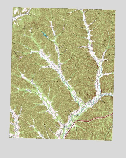
Cranston, KY USGS Topographic Map
Click on map above to begin viewing in our Map Viewer.

This topographic map contains these locations and features:
Feature Name Type Latitude Longitude GNIS ID View Map
Adams BranchStreamN38.3523°W83.4066°510214View Map
Adams CemeteryCemeteryN38.3548°W83.4049°510216View Map
Adams Davis School (historical)SchoolN38.3548°W83.4100°2127185View Map
Adams-Plank CemeteryCemeteryN38.3546°W83.4053°2079426View Map
Alpha Bradley BranchStreamN38.3359°W83.4446°510246View Map
Anderson CemeteryCemeteryN38.3265°W83.4540°2079431View Map
Anderson Family CemeteryCemeteryN38.3198°W83.4482°2079432View Map
Anna Ham BranchStreamN38.3423°W83.4482°510281View Map
Barn BranchStreamN38.3573°W83.4088°510407View Map
Bates BranchStreamN38.3029°W83.4324°510428View Map
Ben Ham BranchStreamN38.3309°W83.4802°510551View Map
Big Brushy (historical)Populated PlaceN38.2614°W83.4914°2127195View Map
Big Long BranchStreamN38.3173°W83.3905°510677View Map
Big Tom Brown BranchStreamN38.2931°W83.3777°510704View Map
Bill Brown HollowValleyN38.3746°W83.4151°510715View Map
Blanton-White CemeteryCemeteryN38.2900°W83.4187°2079456View Map
Blevins BranchStreamN38.2734°W83.4457°510786View Map
Blind BranchStreamN38.2934°W83.3774°510790View Map
Browning BranchStreamN38.3045°W83.3924°510953View Map
Buckner BranchStreamN38.3467°W83.4066°511030View Map
Bumgardner CemeteryCemeteryN38.2508°W83.4932°2079666View Map
Burnt House BranchStreamN38.3390°W83.3821°511087View Map
Burrs BranchStreamN38.3215°W83.4421°511089View Map
Buttermilk BranchStreamN38.3029°W83.4324°511102View Map
Carpenter BranchStreamN38.3320°W83.4713°511223View Map
Caudill BranchStreamN38.3456°W83.4757°511250View Map
Cincinnati BranchStreamN38.2917°W83.4649°511366View Map
Clark Cemetery TwoCemeteryN38.3147°W83.3948°2079705View Map
Clark School (historical)SchoolN38.3179°W83.3913°2127597View Map
Clark School (historical)SchoolN38.3179°W83.3913°2127184View Map
Clay BranchStreamN38.2790°W83.4116°511379View Map
Clear Creek SchoolSchoolN38.2944°W83.4642°2095577View Map
Clear ForkStreamN38.2617°W83.4332°511400View Map
Clear Fork School (historical)SchoolN38.2948°W83.4643°2127585View Map
Clear Fork School (historical)SchoolN38.2948°W83.4643°2127179View Map
Cooper CemeteryTwoCemeteryN38.2578°W83.4949°2079719View Map
Cooper ChapelChurchN38.2581°W83.4924°511518View Map
Cow BranchStreamN38.3315°W83.4674°511587View Map
CranstonPopulated PlaceN38.2634°W83.4355°511626View Map
Cranston CemeteryCemeteryN38.2612°W83.4349°2079724View Map
Cranston School (historical)SchoolN38.2627°W83.4339°2127587View Map
Cranston School (historical)SchoolN38.2627°W83.4339°2127180View Map
DeBord BranchStreamN38.2512°W83.4346°511751View Map
Deer Lick BranchStreamN38.3512°W83.4491°511772View Map
Doe BranchStreamN38.3298°W83.3996°511848View Map
Dogtrot BranchStreamN38.3431°W83.3819°511857View Map
Drake CemeteryCemeteryN38.3272°W83.4870°2079739View Map
Dry BranchStreamN38.3131°W83.3907°511916View Map
Duff BranchStreamN38.2848°W83.4166°511941View Map
Easton BranchStreamN38.3109°W83.4385°512001View Map
Elk Lick ForkStreamN38.3190°W83.3902°512043View Map
Emory BranchStreamN38.2609°W83.4338°512069View Map
Estep BranchStreamN38.2842°W83.4041°512088View Map
Estep CemeteryCemeteryN38.2875°W83.4051°2079749View Map
Evans BranchStreamN38.2976°W83.3916°512094View Map
Evans CemeteryCemeteryN38.2998°W83.3943°512096View Map
Fisher BranchStreamN38.2734°W83.4224°512171View Map
Hale Morgan BranchStreamN38.2840°W83.4016°512506View Map
Hall BranchStreamN38.2873°W83.4213°512518View Map
Ham BranchStreamN38.3190°W83.4527°512533View Map
Hamm CemeteryCemeteryN38.2544°W83.4606°2079793View Map
Haney BranchStreamN38.2684°W83.4241°512544View Map
Harper BranchStreamN38.3023°W83.4735°512568View Map
Hawkins BranchStreamN38.2770°W83.4505°512602View Map
Hickory Flats Lookout TowerTowerN38.3415°W83.3946°517173View Map
Hickory Lick BranchStreamN38.3359°W83.3844°512688View Map
Hilda-Triplett DivisionCivilN38.2813°W83.4632°1937202View Map
Hogge BranchStreamN38.2701°W83.4244°512733View Map
Hogge CemeteryCemeteryN38.2726°W83.4271°512734View Map
Holly ForkStreamN38.2937°W83.3910°512753View Map
Humphreys BranchStreamN38.2684°W83.4924°512849View Map
Humphries CemeteryCemeteryN38.3090°W83.4836°2079820View Map
Hyatt BranchStreamN38.3309°W83.4802°512878View Map
Ike Stacy BranchStreamN38.3745°W83.4769°512889View Map
Island ForkStreamN38.3142°W83.4427°512940View Map
Island Fork School (historical)SchoolN38.3391°W83.4460°2127161View Map
Jimmie BranchStreamN38.3673°W83.4894°513013View Map
Kinder BranchStreamN38.3742°W83.4202°513143View Map
Lake LewmanReservoirN38.3493°W83.4600°513367View Map
Lick BranchStreamN38.2856°W83.4560°513389View Map
Little Long BranchStreamN38.3167°W83.3952°513503View Map
Little White Pine HollowValleyN38.3276°W83.3854°513536View Map
Logan BranchStreamN38.3645°W83.4513°513571View Map
Maddox-Hamm CemeteryCemeteryN38.3337°W83.4678°2079868View Map
Mann BranchStreamN38.3642°W83.4121°513770View Map
McClurg BranchStreamN38.3004°W83.3913°513853View Map
McCormic-McClure CemeteryCemeteryN38.3269°W83.3945°2079906View Map
Mill BranchStreamN38.3084°W83.4846°513973View Map
Mill BranchStreamN38.3467°W83.3807°513974View Map
Mock BranchStreamN38.3715°W83.4144°514038View Map
Molton CemeteryCemeteryN38.3094°W83.4353°2079918View Map
Moore BranchStreamN38.2687°W83.4252°514041View Map
Mudlick BranchStreamN38.3692°W83.4816°514148View Map
Mullen CemeteryCemeteryN38.3163°W83.4913°2079926View Map
Munson Post Office (historical)Post OfficeN38.2602°W83.4372°2127181View Map
Murray BranchStreamN38.2587°W83.4924°514168View Map
Muse BranchStreamN38.2834°W83.4549°514170View Map
Muse CemeteryCemeteryN38.2860°W83.4913°2079927View Map
New Hope ChurchChurchN38.2623°W83.4338°514241View Map
Nickell BranchStreamN38.2906°W83.3935°514268View Map
Pine Grove CemeteryCemeteryN38.2858°W83.4109°2079943View Map
Pine Grove MissionChurchN38.2884°W83.4021°514581View Map
Pine Spring Post Office (historical)Post OfficeN38.3179°W83.4451°2127176View Map
Plank BranchStreamN38.3320°W83.4746°514636View Map
Plank ChurchChurchN38.3231°W83.3952°514637View Map
Plank Family CemeteryCemeteryN38.3401°W83.4032°2079945View Map
Poplar HollowValleyN38.3384°W83.4070°514716View Map
Rattlesnake BranchStreamN38.3476°W83.4474°514844View Map
Right Fork Burnt House BranchStreamN38.3398°W83.3769°514934View Map
Road BranchStreamN38.2629°W83.4185°514977View Map
Roberts BranchStreamN38.3090°W83.4385°515000View Map
Rock ForkStreamN38.2784°W83.4127°515026View Map
Route 377 Fire DepartmentBuildingN38.2861°W83.4056°2636394View Map
RyanPopulated PlaceN38.3701°W83.4827°515152View Map
Ryan Post Office (historical)Post OfficeN38.3695°W83.4828°2355284View Map
Sardis CemeteryCemeteryN38.3006°W83.4693°517325View Map
Sardis ChurchChurchN38.3001°W83.4700°2127178View Map
Schoolhouse BranchStreamN38.2895°W83.3999°515289View Map
Schoolhouse BranchStreamN38.3392°W83.4460°515291View Map
Shop BranchStreamN38.2876°W83.3991°515369View Map
SmilePopulated PlaceN38.2576°W83.4902°515502View Map
Smile Post Office (historical)Post OfficeN38.2569°W83.4913°2127215View Map
Sparks BranchStreamN38.3706°W83.3796°515565View Map
Stevens CemeteryCemeteryN38.2957°W83.3790°2079988View Map
Tar BranchStreamN38.3106°W83.3921°515861View Map
Tarkhill BranchStreamN38.2965°W83.4674°515865View Map
Tater Lick BranchStreamN38.3573°W83.4088°515875View Map
Tilden-Hogge SchoolSchoolN38.2734°W83.4266°515949View Map
TriplettPopulated PlaceN38.2934°W83.3963°516022View Map
Triplett Post Office (historical)Post OfficeN38.2931°W83.3964°2127183View Map
WaltzPopulated PlaceN38.3167°W83.4441°516221View Map
Waltz Post Office (historical)Post OfficeN38.3174°W83.4447°2127162View Map
Waltz School (historical)SchoolN38.3174°W83.4458°2127175View Map
Wes Bradley BranchStreamN38.3298°W83.4438°516272View Map
Whisman CemeteryCemeteryN38.3315°W83.4413°516295View Map
Whisman CemeteryCemeteryN38.3314°W83.4419°2080034View Map
White BranchStreamN38.2940°W83.3860°516303View Map
White Cemetery FiveCemeteryN38.2775°W83.4225°2080044View Map
White Pine HollowValleyN38.3267°W83.3879°516329View Map
Wyatt CemeteryCemeteryN38.3316°W83.4614°2080054View Map

Note: Coordinates in the location and feature list above are referenced to NAD83 datum.


Copyright (C) 2008-2024 Ryan Niemi / Sunset Dynamics ... All Rights Reserved