TopoQuest Logo
Do you find TopoQuest useful?
Help keep TopoQuest running and adding new maps/features by donating!
Bitcoin:  19c7KJd3qBynnjoSw5npx9KScwjBe4ifkT
Litecoin:  LXs6TkuXGGXo1vDsWCkWVdjQX94eUKd6ui
Home View Maps Find Maps Find Places Resources & Links


Farmers, Kentucky Topographic Map

USGS Map Title: Farmers, KY
USGS Map MRC: 38083B5
DRG (GeoTIFF) Download: o38083b5.tif


Neighboring USGS Topographic Map Quads:


  Hillsboro, KY  
38083C6
 

  Plummers Landing, KY  
38083C5
 

  Cranston, KY  
38083C4
 

  Colfax, KY  
38083B6
 

  Farmers, KY  
38083B5
 

  Morehead, KY  
38083B4
 

  Olympia, KY  
38083A6
 

  Salt Lick, KY  
38083A5
 

  Bangor, KY  
38083A4


Map MRC Location:

N39°
W84°
N39°
W83°
H8 H7 H6 H5 H4 H3 H2 H1
G8 G7 G6 G5 G4 G3 G2 G1
F8 F7 F6 F5 F4 F3 F2 F1
E8 E7 E6 E5 E4 E3 E2 E1
D8 D7 D6 D5 D4 D3 D2 D1
C8 C7 C6 C5 C4 C3 C2 C1
B8 B7 B6 B5 B4 B3 B2 B1
A8 A7 A6 A5 A4 A3 A2 A1
N38°
W84°
N38°
W83°

Farmers, KY USGS 1:24K Topographic Map Preview:
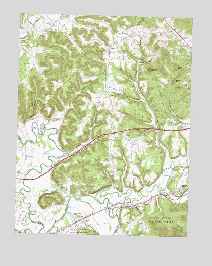
Farmers, KY USGS Topographic Map
Click on map above to begin viewing in our Map Viewer.

This topographic map contains these locations and features:
Feature Name Type Latitude Longitude GNIS ID View Map
Bayou CreekStreamN38.1451°W83.5780°510436View Map
Blue Bank School (historical)SchoolN38.1801°W83.5725°2127223View Map
Bluebank BranchStreamN38.1698°W83.5902°510808View Map
Bluebank ChurchChurchN38.1695°W83.5869°510810View Map
BluestonePopulated PlaceN38.1498°W83.5113°510812View Map
Boone HollowValleyN38.2249°W83.5381°510848View Map
Brown Cemetery FiveCemeteryN38.2252°W83.5134°2079654View Map
Buckner BranchStreamN38.2206°W83.6132°511029View Map
Bull ForkStreamN38.1623°W83.5177°511050View Map
Buzzard KnobSummitN38.2137°W83.5124°511113View Map
Caskey CemeteryCemeteryN38.1890°W83.5110°2079680View Map
Cassity Cemetery TwoCemeteryN38.1425°W83.5321°2079686View Map
Caudill Cemetery TwoCemeteryN38.2399°W83.5426°2079694View Map
City of Lakeview HeightsCivilN38.1520°W83.5044°2404877View Map
Cow CreekStreamN38.1473°W83.6207°511591View Map
Craycraft CemeteryCemeteryN38.1391°W83.5481°2079725View Map
Crooked RunStreamN38.1373°W83.6135°511651View Map
Curtis BranchStreamN38.2226°W83.5391°511686View Map
Dane Greer HillSummitN38.1484°W83.5207°507364View Map
Davis HollowValleyN38.2296°W83.5791°511742View Map
Denton CemeteryCemeteryN38.2376°W83.6080°511791View Map
DeWitt CemeteryCemeteryN38.1729°W83.5173°2079736View Map
Eagle Trace Golf CourseLocaleN38.1922°W83.5747°2127221View Map
Eldridge Cemetery OneCemeteryN38.2254°W83.5341°516755View Map
Ellington Farm CemeteryCemeteryN38.1732°W83.5886°2079744View Map
Emmons CemeteryCemeteryN38.2474°W83.5938°2355199View Map
FarmersPopulated PlaceN38.1429°W83.5460°512136View Map
Farmers Census Designated PlaceCensusN38.1406°W83.5414°2629615View Map
Farmers Christian ChurchChurchN38.1403°W83.5486°2367849View Map
Farmers ChurchChurchN38.1434°W83.5319°512137View Map
Farmers Elementary School (historical)SchoolN38.1425°W83.5426°2519195View Map
Farmers Volunteer Fire Department Station 1BuildingN38.1429°W83.5466°2636431View Map
Farmers Volunteer Fire Department Station 2BuildingN38.2018°W83.5569°2636976View Map
Filson CemeteryCemeteryN38.2400°W83.6189°2355211View Map
Flag BranchStreamN38.2434°W83.5924°512181View Map
Fox HollowValleyN38.2127°W83.5408°512233View Map
Freestone Railroad Station (historical)LocaleN38.1483°W83.5231°2127232View Map
Green CemeteryCemeteryN38.1422°W83.6075°2079775View Map
Green MountainSummitN38.1465°W83.5974°512440View Map
Happy HollowValleyN38.2288°W83.6176°512556View Map
Hawkins PondLakeN38.1294°W83.6184°512604View Map
HildaPopulated PlaceN38.2381°W83.5077°512704View Map
Hilda Post Office (historical)Post OfficeN38.2388°W83.5077°2127227View Map
Hilda School (historical)SchoolN38.2370°W83.5062°2127228View Map
Horseshoe BendBendN38.1817°W83.6060°512802View Map
Hungry BranchStreamN38.1495°W83.5202°512850View Map
Ingram BendBendN38.1865°W83.6121°512918View Map
Ingram CemeteryCemeteryN38.1888°W83.5907°2079821View Map
Ingram-Stevens CemeteryCemeteryN38.1412°W83.5492°2079822View Map
Isles Mills Post Office (historical)Post OfficeN38.1587°W83.6224°2416415View Map
James-Jones CemeteryCemeteryN38.1522°W83.5933°2079827View Map
John Will Stacey Business ParkLocaleN38.2002°W83.5517°2127220View Map
Johnson Black CemeteryCemeteryN38.2005°W83.5726°2079449View Map
Jones CemeteryCemeteryN38.1326°W83.5735°513067View Map
Kissick CemeteryCemeteryN38.2150°W83.5705°2079857View Map
Kissick HollowValleyN38.2131°W83.6055°2355239View Map
Lakeview HeightsPopulated PlaceN38.1515°W83.5044°513192View Map
Licking Post Office (historical)Post OfficeN38.1543°W83.5224°2127230View Map
Licking Railroad Station (historical)LocaleN38.1406°W83.5576°2127236View Map
Markwell CemeteryCemeteryN38.1998°W83.5308°2079870View Map
McGlosson CemeteryCemeteryN38.1422°W83.5324°2079913View Map
MidlandPopulated PlaceN38.1331°W83.5777°513953View Map
Midland Church of GodChurchN38.1327°W83.5779°2416437View Map
Midland Railroad Station (historical)LocaleN38.1288°W83.5910°2416438View Map
Moore Cemetery TwoCemeteryN38.1430°W83.5424°2079922View Map
Moore School (historical)SchoolN38.1602°W83.5993°2127229View Map
Moores FerryLocaleN38.1679°W83.6182°498564View Map
Moores Ferry Post Office (historical)Post OfficeN38.1684°W83.6185°2416443View Map
Morehead-Rowan County Clyde A Thomas Regional AirportAirportN38.2142°W83.5860°517442View Map
Morgans Fourth Raid Historical MarkerParkN38.1411°W83.5478°2745142View Map
Mount Pisgah CemeteryCemeteryN38.2378°W83.5106°2080060View Map
Mount Pisgah ChurchChurchN38.2373°W83.5110°498819View Map
Muleshoe BendBendN38.1856°W83.6066°499078View Map
Murphy BranchStreamN38.1492°W83.5471°514166View Map
North Fork Triplett CreekStreamN38.1515°W83.5194°514293View Map
Padgett BranchStreamN38.1498°W83.5338°514413View Map
Parsons CemeteryCemeteryN38.1727°W83.5887°2079934View Map
Pence CemeteryCemeteryN38.2252°W83.5340°2079935View Map
Pint Lick BranchStreamN38.2015°W83.5330°514619View Map
Poplar Spring ChurchChurchN38.2395°W83.5469°514719View Map
RameyPopulated PlaceN38.1792°W83.5719°514833View Map
Ramey Post Office (historical)Post OfficeN38.1872°W83.6023°2127222View Map
Razor CemeteryCemeteryN38.1564°W83.5995°2079957View Map
Restland CemeteryCemeteryN38.2128°W83.5237°2079959View Map
Reynolds CemeteryCemeteryN38.1675°W83.5590°2079960View Map
Rock Lick CreekStreamN38.2431°W83.6005°515034View Map
Rock Lick School (historical)SchoolN38.2474°W83.5938°2355282View Map
Rockville Railroad Station (historical)LocaleN38.1493°W83.5148°2127231View Map
Sand BranchStreamN38.1865°W83.5238°515210View Map
Scaggs CemeteryCemeteryN38.2465°W83.5740°2079971View Map
SharkeyPopulated PlaceN38.2309°W83.5599°515337View Map
Sharkey ChurchChurchN38.2320°W83.5569°2127216View Map
Sharkey Post Office (historical)Post OfficeN38.2328°W83.5605°2355291View Map
Sharkey School (historical)SchoolN38.2325°W83.5575°2127217View Map
Siloam CemeteryCemeteryN38.1591°W83.5122°2079978View Map
Siloam ChurchChurchN38.1590°W83.5116°515412View Map
Slatey (historical)Populated PlaceN38.1482°W83.5999°2127226View Map
Slatey ChurchChurchN38.1520°W83.5913°515478View Map
Slatey School (historical)SchoolN38.1525°W83.5717°2127225View Map
Smoky KnobSummitN38.2209°W83.5105°515519View Map
Snedegar PondLakeN38.1714°W83.6033°515525View Map
Spring Grove LakesReservoirN38.1351°W83.5824°515611View Map
Sugarloaf MountainSummitN38.2195°W83.5299°515801View Map
Sulphur HollowValleyN38.1969°W83.5849°515808View Map
Swim BranchStreamN38.1887°W83.5246°515836View Map
Swim Family CemeteryCemeteryN38.1732°W83.5888°2079994View Map
Tar BranchStreamN38.2445°W83.5899°515860View Map
Three Lick BranchStreamN38.1870°W83.6046°515938View Map
Triplett CreekStreamN38.1459°W83.5669°516023View Map
Woodford Black CemeteryCemeteryN38.2383°W83.5543°2079452View Map

Note: Coordinates in the location and feature list above are referenced to NAD83 datum.


Copyright (C) 2008-2024 Ryan Niemi / Sunset Dynamics ... All Rights Reserved