TopoQuest Logo
Do you find TopoQuest useful?
Help keep TopoQuest running and adding new maps/features by donating!
Bitcoin:  19c7KJd3qBynnjoSw5npx9KScwjBe4ifkT
Litecoin:  LXs6TkuXGGXo1vDsWCkWVdjQX94eUKd6ui
Home View Maps Find Maps Find Places Resources & Links


Plummers Landing, Kentucky Topographic Map

USGS Map Title: Plummers Landing, KY
USGS Map MRC: 38083C5
DRG (GeoTIFF) Download: o38083c5.tif


Neighboring USGS Topographic Map Quads:


  Flemingsburg, KY  
38083D6
 

  Burtonville, KY  
38083D5
 

  Stricklett, KY  
38083D4
 

  Hillsboro, KY  
38083C6
 

  Plummers Landing, KY  
38083C5
 

  Cranston, KY  
38083C4
 

  Colfax, KY  
38083B6
 

  Farmers, KY  
38083B5
 

  Morehead, KY  
38083B4


Map MRC Location:

N39°
W84°
N39°
W83°
H8 H7 H6 H5 H4 H3 H2 H1
G8 G7 G6 G5 G4 G3 G2 G1
F8 F7 F6 F5 F4 F3 F2 F1
E8 E7 E6 E5 E4 E3 E2 E1
D8 D7 D6 D5 D4 D3 D2 D1
C8 C7 C6 C5 C4 C3 C2 C1
B8 B7 B6 B5 B4 B3 B2 B1
A8 A7 A6 A5 A4 A3 A2 A1
N38°
W84°
N38°
W83°

Plummers Landing, KY USGS 1:24K Topographic Map Preview:
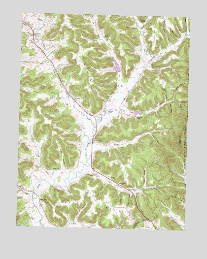
Plummers Landing, KY USGS Topographic Map
Click on map above to begin viewing in our Map Viewer.

This topographic map contains these locations and features:
Feature Name Type Latitude Longitude GNIS ID View Map
Anderson BranchStreamN38.3670°W83.5380°510266View Map
Baxter BranchStreamN38.3251°W83.5160°510434View Map
Belle Grove Spring Resort (historical)ParkN38.3161°W83.5380°2355166View Map
Belle Grove SpringsLocaleN38.3159°W83.5382°510545View Map
Big RunStreamN38.3259°W83.5546°510691View Map
Big Run SchoolSchoolN38.3604°W83.5624°510692View Map
Bishop MountainSummitN38.3072°W83.5444°2355171View Map
Bluebank BranchStreamN38.3645°W83.6163°510809View Map
Bradley-Moore CemeteryCemeteryN38.2848°W83.5070°2079465View Map
Brushy ForkStreamN38.3442°W83.5377°510978View Map
Crane CreekStreamN38.2820°W83.5777°511622View Map
Crane Creek ChurchChurchN38.2756°W83.5474°511623View Map
Daulton SchoolSchoolN38.2709°W83.5719°511725View Map
Dragslab HollowValleyN38.3241°W83.5061°511883View Map
Drip Springs HollowValleyN38.2528°W83.5813°511889View Map
Emmons SchoolSchoolN38.3221°W83.6030°2355200View Map
Evans HollowValleyN38.2845°W83.5907°512099View Map
Farmville (historical)Populated PlaceN38.2688°W83.6108°2355209View Map
Farmville ChurchChurchN38.2649°W83.6093°2355210View Map
Farris BranchStreamN38.3420°W83.5999°512138View Map
Fox Valley Community ChurchChurchN38.3111°W83.5600°2367850View Map
Franklins Mill Post Office (historical)Post OfficeN38.3261°W83.5896°2355221View Map
Franklins Mill School (historical)SchoolN38.3262°W83.5896°2355222View Map
Fryman CemeteryCemeteryN38.2828°W83.5030°2079766View Map
GoddardPopulated PlaceN38.3626°W83.6146°512335View Map
Goddard Covered BridgeBridgeN38.3624°W83.6159°2355223View Map
Goddard United Methodist ChurchChurchN38.3622°W83.6138°2355224View Map
Goddard White Covered Bridge Historical MarkerParkN38.3623°W83.6153°2744371View Map
Greenbrier BranchStreamN38.3459°W83.5299°512444View Map
Hedger BranchStreamN38.3670°W83.5380°512631View Map
Hedger ChapelChurchN38.3623°W83.5632°512632View Map
Henderson BranchStreamN38.3604°W83.5644°512646View Map
Hillsboro DivisionCivilN38.3100°W83.6247°1937061View Map
Howell CemeteryCemeteryN38.2751°W83.5016°2079818View Map
Hurst CemeteryCemeteryN38.3084°W83.5777°512874View Map
Hurst HollowValleyN38.3349°W83.5882°512875View Map
Indian CreekStreamN38.2906°W83.5728°512900View Map
Jack HollowValleyN38.3645°W83.5052°512945View Map
Jackson Family CemeteryCemeteryN38.2535°W83.5297°2079825View Map
Jackson HollowValleyN38.3582°W83.5142°512971View Map
Johnson HollowValleyN38.2722°W83.5885°513051View Map
Jones HollowValleyN38.2724°W83.5488°513072View Map
Knob Lick BranchStreamN38.3445°W83.5532°513164View Map
Littleton BranchStreamN38.3298°W83.5910°513545View Map
Martin Mill BranchStreamN38.2751°W83.5977°513809View Map
Maxey FlatsFlatN38.2654°W83.5666°510184View Map
Moore Cemetery ThreeCemeteryN38.2819°W83.5012°2079923View Map
Moran BranchStreamN38.3209°W83.5602°514050View Map
Morrison BranchStreamN38.3259°W83.5124°514073View Map
Mount Vernon CemeteryCemeteryN38.3256°W83.5960°516737View Map
Mount Vernon ChurchChurchN38.3248°W83.5841°514114View Map
Mountain Lake ManorLocaleN38.3156°W83.5378°2367853View Map
Muses MillLocaleN38.3094°W83.5225°2355255View Map
Muses Mill Post Office (historical)Post OfficeN38.3504°W83.5270°2355256View Map
Muses Mill Volunteer Fire DepartmentBuildingN38.3411°W83.5357°2367854View Map
Muses MillsPopulated PlaceN38.3501°W83.5271°514171View Map
Muses Mills Christian ChurchChurchN38.3486°W83.5287°2367855View Map
Muses Mills Church CemeteryCemeteryN38.3486°W83.5287°2367856View Map
Newman CemeteryCemeteryN38.2842°W83.5935°514259View Map
Orange Post Office (historical)Post OfficeN38.2732°W83.5881°2355265View Map
Plummers LandingPopulated PlaceN38.3190°W83.5610°514665View Map
Plummers Landing Post Office (historical)Post OfficeN38.3190°W83.5610°2355274View Map
Plummers Landing School (historical)SchoolN38.3184°W83.5610°2355275View Map
Plummers MillPopulated PlaceN38.3006°W83.5696°514666View Map
Plummers Mill Post Office (historical)Post OfficeN38.3195°W83.5588°2355276View Map
Point Pleasant CemeteryCemeteryN38.3392°W83.5438°514668View Map
Point Pleasant Church (historical)ChurchN38.3396°W83.5437°2355277View Map
Ramey ChapelChurchN38.3712°W83.5349°514834View Map
Reed HollowValleyN38.2750°W83.5301°514878View Map
Ringos Mill Covered Bridge Historical MarkerParkN38.2683°W83.6106°2744373View Map
Ringos MillsLocaleN38.2656°W83.6080°514970View Map
Ringos Mills BridgeBridgeN38.2684°W83.6102°2355281View Map
Rocky HollowValleyN38.3245°W83.5141°515077View Map
Sand Lick CreekStreamN38.3090°W83.5682°515224View Map
Sand MountainSummitN38.2979°W83.5247°2355287View Map
Shiloh ChurchChurchN38.3020°W83.5696°515355View Map
Skinner CemeteryCemeteryN38.2548°W83.6141°515456View Map
Spice LickStreamN38.2729°W83.5385°515586View Map
Spruce HollowValleyN38.3057°W83.5274°515625View Map
Stockton CreekStreamN38.3227°W83.5576°515720View Map
Stockton Grave Historical MarkerParkN38.3071°W83.5670°2744369View Map
Stone Lick BranchStreamN38.2690°W83.6155°515725View Map
Stone Lick School (historical)SchoolN38.2728°W83.6224°2355298View Map
Sugar Tree BranchStreamN38.3642°W83.5030°515793View Map
Sugar Tree Run School (historical)SchoolN38.3687°W83.5022°2355299View Map
Sulphur Springs HollowValleyN38.2770°W83.5592°515812View Map
Toadvine BranchStreamN38.3365°W83.5524°515960View Map
Trace RunStreamN38.3454°W83.6024°516015View Map
Wallingford Post Office (historical)Post OfficeN38.2824°W83.6127°2355316View Map
Weasel HollowValleyN38.3618°W83.5088°516253View Map
Weaver HollowValleyN38.2705°W83.5402°516256View Map
White Oak Hill Post Office (historical)Post OfficeN38.2550°W83.5247°2355318View Map
Wildcat BranchStreamN38.2750°W83.5241°2355319View Map

Note: Coordinates in the location and feature list above are referenced to NAD83 datum.


Copyright (C) 2008-2024 Ryan Niemi / Sunset Dynamics ... All Rights Reserved