TopoQuest Logo
Do you find TopoQuest useful?
Help keep TopoQuest running and adding new maps/features by donating!
Bitcoin:  19c7KJd3qBynnjoSw5npx9KScwjBe4ifkT
Litecoin:  LXs6TkuXGGXo1vDsWCkWVdjQX94eUKd6ui
Home View Maps Find Maps Find Places Resources & Links


Stricklett, Kentucky Topographic Map

USGS Map Title: Stricklett, KY
USGS Map MRC: 38083D4
DRG (GeoTIFF) Download: o38083d4.tif


Neighboring USGS Topographic Map Quads:


  Tollesboro, KY  
38083E5
 

  Charters, KY  
38083E4
 

  Vanceburg, KY  
38083E3
 

  Burtonville, KY  
38083D5
 

  Stricklett, KY  
38083D4
 

  Head of Grassy, KY  
38083D3
 

  Plummers Landing, KY  
38083C5
 

  Cranston, KY  
38083C4
 

  Soldier, KY  
38083C3


Map MRC Location:

N39°
W84°
N39°
W83°
H8 H7 H6 H5 H4 H3 H2 H1
G8 G7 G6 G5 G4 G3 G2 G1
F8 F7 F6 F5 F4 F3 F2 F1
E8 E7 E6 E5 E4 E3 E2 E1
D8 D7 D6 D5 D4 D3 D2 D1
C8 C7 C6 C5 C4 C3 C2 C1
B8 B7 B6 B5 B4 B3 B2 B1
A8 A7 A6 A5 A4 A3 A2 A1
N38°
W84°
N38°
W83°

Stricklett, KY USGS 1:24K Topographic Map Preview:
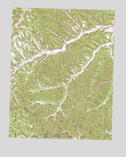
Stricklett, KY USGS Topographic Map
Click on map above to begin viewing in our Map Viewer.

This topographic map contains these locations and features:
Feature Name Type Latitude Longitude GNIS ID View Map
Bear BranchStreamN38.4831°W83.3907°510458View Map
Bee BranchStreamN38.4579°W83.4560°510501View Map
Bee BranchStreamN38.4540°W83.3757°510503View Map
Big BranchStreamN38.4273°W83.4010°510624View Map
Big BranchStreamN38.4504°W83.4052°510625View Map
Big HollowValleyN38.4098°W83.4682°510664View Map
Big Johnson HollowValleyN38.4367°W83.3923°510667View Map
Big Lick HollowValleyN38.3824°W83.3806°510675View Map
Bill Rice BranchStreamN38.4079°W83.4724°510718View Map
Bishop BranchStreamN38.4073°W83.3894°510741View Map
Black Lick BranchStreamN38.4659°W83.4332°510751View Map
Black Stairs BranchStreamN38.3765°W83.4741°510756View Map
Bob Cooper HollowValleyN38.3871°W83.4177°510822View Map
Bobbie BranchStreamN38.4148°W83.3796°510824View Map
Briery CreekStreamN38.4681°W83.3796°510923View Map
Brown Cemetery ThreeCemeteryN38.3813°W83.4093°2079651View Map
Brown HollowValleyN38.3809°W83.3772°510948View Map
Buck Lick BranchStreamN38.4579°W83.3782°511010View Map
Buck Lick RidgeRidgeN38.4215°W83.3957°511013View Map
Buckner CemeteryCemeteryN38.3803°W83.4257°511032View Map
Burnt Cabin BranchStreamN38.4579°W83.4594°511084View Map
Cloddy Field BranchStreamN38.4361°W83.4217°511415View Map
Clover Field BranchStreamN38.4326°W83.4255°511421View Map
Cooper Fork BranchStreamN38.4223°W83.4613°511521View Map
CrumPopulated PlaceN38.4598°W83.4505°511665View Map
Crum Post Office (historical)Post OfficeN38.4600°W83.4503°2362977View Map
Duff HollowValleyN38.3971°W83.4337°511943View Map
Dunaway BranchStreamN38.4426°W83.4902°511952View Map
Elk Lick BranchStreamN38.4729°W83.4180°512041View Map
Hardin HollowValleyN38.3814°W83.4746°512560View Map
Hardy ForkStreamN38.4079°W83.4385°512563View Map
Henderson CemeteryCemeteryN38.3830°W83.4159°2079801View Map
Henderson HollowValleyN38.3810°W83.3887°512648View Map
Henry Short HollowValleyN38.3850°W83.4156°512661View Map
Hog Camp BranchStreamN38.4329°W83.3752°512726View Map
House BranchStreamN38.4584°W83.3977°512813View Map
Jess Canille BranchStreamN38.4187°W83.3785°513001View Map
Jordan BranchStreamN38.4106°W83.3839°513081View Map
Kilan BranchStreamN38.4045°W83.3963°513137View Map
Kincaid BranchStreamN38.4292°W83.4294°513141View Map
Kinniconick SchoolSchoolN38.4665°W83.4360°513156View Map
Kinniconick Volunteer Fire DepartmentBuildingN38.4838°W83.3766°2636586View Map
Laurel-Petersville DivisionCivilN38.4340°W83.3770°1937097View Map
Lee BranchStreamN38.4579°W83.4499°513293View Map
Little BranchStreamN38.4301°W83.4288°513453View Map
Long BranchStreamN38.4050°W83.3936°513602View Map
Long BranchStreamN38.4776°W83.4110°513611View Map
McCless HollowValleyN38.3819°W83.4350°513851View Map
McCless HollowValleyN38.4025°W83.4384°513852View Map
McEldowney CemeteryCemeteryN38.4676°W83.4363°513858View Map
Middle Indian SchoolSchoolN38.4290°W83.4305°513943View Map
Middle Lick BranchStreamN38.3829°W83.3799°513944View Map
Mill BranchStreamN38.4576°W83.3977°513975View Map
Nickles HollowValleyN38.3790°W83.4130°514269View Map
Noah Post Office (historical)Post OfficeN38.4690°W83.4963°2363036View Map
Oak Ridge (historical)Populated PlaceN38.4690°W83.4963°2363039View Map
Oak Ridge ChurchChurchN38.4690°W83.4946°514303View Map
Oil Well HollowValleyN38.4254°W83.3756°514313View Map
Owl HollowValleyN38.4249°W83.4464°514397View Map
Paint Lick BranchStreamN38.4552°W83.4634°514422View Map
Pea Vine BranchStreamN38.4595°W83.3966°514464View Map
PetersvillePopulated PlaceN38.4442°W83.4905°514523View Map
Petersville Post Office (historical)Post OfficeN38.4440°W83.4911°2363043View Map
Pitts HollowValleyN38.4146°W83.4251°514631View Map
Polecat BranchStreamN38.4073°W83.3894°514675View Map
Reed School (historical)SchoolN38.3786°W83.4752°2355280View Map
Riley BranchStreamN38.4115°W83.3838°514965View Map
Road Fork HollowValleyN38.3857°W83.3822°514986View Map
Rock Camp BranchStreamN38.4476°W83.4838°515021View Map
Sheltowee Trailhead ParkingLocaleN38.3845°W83.4149°516754View Map
Siam HollowValleyN38.4196°W83.4958°515400View Map
Silver Lick HollowValleyN38.4432°W83.4130°515414View Map
Silver Lick HollowValleyN38.4595°W83.4374°515415View Map
Smith HollowValleyN38.4167°W83.4032°515514View Map
Stamm ForkStreamN38.4251°W83.4313°515651View Map
Stein BranchStreamN38.4142°W83.3816°515685View Map
StricklettPopulated PlaceN38.4845°W83.3874°515756View Map
Thackers ChapelChurchN38.4345°W83.4255°515901View Map
The Black StairsSummitN38.3760°W83.4681°2355309View Map
Thomas BranchStreamN38.4334°W83.4249°515926View Map
Thomson Landing (historical)LocaleN38.4759°W83.4759°2363085View Map
Thurman BranchStreamN38.4170°W83.4307°515943View Map
Troy Gilmore HollowValleyN38.4239°W83.3774°516028View Map
Trumstock BranchStreamN38.4798°W83.4016°516030View Map
Ulett HollowValleyN38.4237°W83.4009°516094View Map
Union ChurchChurchN38.4781°W83.4127°516100View Map
Upper Indian Creek (historical)Populated PlaceN38.4089°W83.4432°2363093View Map
Upper Indian SchoolSchoolN38.4087°W83.4419°516132View Map
Washman LookoutLocaleN38.4915°W83.4594°516239View Map
Williams Cemetery TwoCemeteryN38.3788°W83.4218°2080049View Map

Note: Coordinates in the location and feature list above are referenced to NAD83 datum.


Copyright (C) 2008-2025 Ryan Niemi / Sunset Dynamics ... All Rights Reserved