TopoQuest Logo
Do you find TopoQuest useful?
Help keep TopoQuest running and adding new maps/features by donating!
Bitcoin:  19c7KJd3qBynnjoSw5npx9KScwjBe4ifkT
Litecoin:  LXs6TkuXGGXo1vDsWCkWVdjQX94eUKd6ui
Home View Maps Find Maps Find Places Resources & Links


Crawfordsville, Iowa Topographic Map

USGS Map Title: Crawfordsville, IA
USGS Map MRC: 41091B5
DRG (GeoTIFF) Download: o41091b5.tif


Neighboring USGS Topographic Map Quads:


  Washington, IA  
41091C6
 

  Ainsworth, IA  
41091C5
 

  Cotter, IA  
41091C4
 

  Wayland, IA  
41091B6
 

  Crawfordsville, IA  
41091B5
 

  Winfield North, IA  
41091B4
 

  Trenton, IA  
41091A6
 

  Swedesburg, IA  
41091A5
 

  Winfield South, IA  
41091A4


Map MRC Location:

N42°
W92°
N42°
W91°
H8 H7 H6 H5 H4 H3 H2 H1
G8 G7 G6 G5 G4 G3 G2 G1
F8 F7 F6 F5 F4 F3 F2 F1
E8 E7 E6 E5 E4 E3 E2 E1
D8 D7 D6 D5 D4 D3 D2 D1
C8 C7 C6 C5 C4 C3 C2 C1
B8 B7 B6 B5 B4 B3 B2 B1
A8 A7 A6 A5 A4 A3 A2 A1
N41°
W92°
N41°
W91°

Crawfordsville, IA USGS 1:24K Topographic Map Preview:
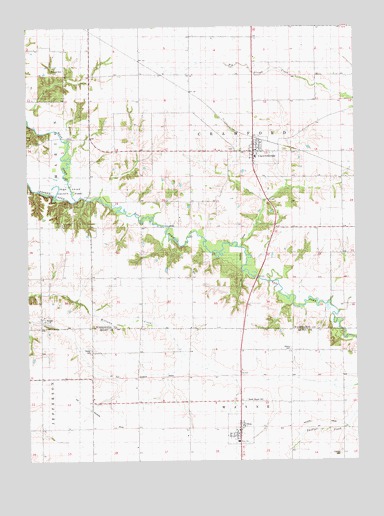
Crawfordsville, IA USGS Topographic Map
Click on map above to begin viewing in our Map Viewer.

This topographic map contains these locations and features:
Feature Name Type Latitude Longitude GNIS ID View Map
Asbury CemeteryCemeteryN41.1571°W91.5253°1825038View Map
Benson CemeteryCemeteryN41.2378°W91.6110°1825045View Map
Center CemeteryCemeteryN41.1566°W91.6014°1825042View Map
City of CrawfordsvilleCivilN41.2139°W91.5366°2393665View Map
City of OldsCivilN41.1342°W91.5442°2396053View Map
CrawfordsvillePopulated PlaceN41.2146°W91.5373°455707View Map
Crawfordsville (historical)LocaleN41.2175°W91.5368°1981754View Map
Crawfordsville CemeteryCemeteryN41.2147°W91.5474°1981815View Map
Crawfordsville City HallBuildingN41.2142°W91.5385°1981757View Map
Crawfordsville Fire Department and First RespondersBuildingN41.2143°W91.5391°2577476View Map
Crawfordsville Post OfficePost OfficeN41.2139°W91.5385°1981753View Map
Crawfordsville United ChurchChurchN41.2145°W91.5379°1981756View Map
Crawfordsville Water Treatment PlantLocaleN41.2164°W91.5356°2728277View Map
Dove FellowshipChurchN41.1342°W91.5449°1981528View Map
East Fork Crooked CreekStreamN41.2006°W91.6088°456142View Map
Fern Cliff ChurchChurchN41.1934°W91.6116°1825043View Map
Fern Cliff County ParkParkN41.2039°W91.6099°1825044View Map
Fern Cliff Evangelic CemeteryCemeteryN41.1937°W91.6118°1981799View Map
Friends CemeteryCemeteryN41.1270°W91.5068°1825037View Map
NoblePopulated PlaceN41.1664°W91.6196°459531View Map
Noble (historical)LocaleN41.1664°W91.6196°1981630View Map
Noble Post Office (historical)Post OfficeN41.1664°W91.6196°1981631View Map
North Wayne CemeteryCemeteryN41.1425°W91.5422°1825039View Map
Old Military Road Historical MarkerParkN41.2125°W91.5390°1981781View Map
OldsPopulated PlaceN41.1342°W91.5449°459848View Map
Olds (historical)LocaleN41.1342°W91.5452°1981523View Map
Olds City HallBuildingN41.1342°W91.5449°1981527View Map
Olds Fire DepartmentBuildingN41.1340°W91.5437°2371701View Map
Olds Post OfficePost OfficeN41.1342°W91.5449°1981525View Map
Olds United Church of ChristChurchN41.1342°W91.5449°1981526View Map
Prairie Ag Co-op ElevatorLocaleN41.1342°W91.5449°1981524View Map
Rumble CemeteryCemeteryN41.1834°W91.6168°1981793View Map
Sycamore MallLocaleN41.2364°W91.5646°463672View Map
Township of CrawfordCivilN41.2065°W91.5434°467663View Map
United Presbyterian ChurchChurchN41.2139°W91.5385°1981752View Map
Waco Elementary SchoolSchoolN41.2125°W91.5382°1981755View Map
Waco SchoolSchoolN41.1306°W91.5454°1825041View Map
Wayne (historical)LocaleN41.1500°W91.5418°1981415View Map
Wayne Post Office (historical)Post OfficeN41.1561°W91.5410°466540View Map
West Fork Crooked CreekStreamN41.2034°W91.6099°462850View Map
Wyman Grain Company ElevatorLocaleN41.2139°W91.5385°1981751View Map

Note: Coordinates in the location and feature list above are referenced to NAD83 datum.


Copyright (C) 2008-2025 Ryan Niemi / Sunset Dynamics ... All Rights Reserved