TopoQuest Logo
Do you find TopoQuest useful?
Help keep TopoQuest running and adding new maps/features by donating!
Bitcoin:  19c7KJd3qBynnjoSw5npx9KScwjBe4ifkT
Litecoin:  LXs6TkuXGGXo1vDsWCkWVdjQX94eUKd6ui
Home View Maps Find Maps Find Places Resources & Links


Crescent Mills, California Topographic Map

USGS Map Title: Crescent Mills, CA
USGS Map MRC: 40120A8
DRG (GeoTIFF) Download: o40120a8.tif


Neighboring USGS Topographic Map Quads:


  Canyondam, CA  
40121B1
 

  Greenville, CA  
40120B8
 

  Moonlight Peak, CA  
40120B7
 

  Twain, CA  
40121A1
 

  Crescent Mills, CA  
40120A8
 

  Taylorsville, CA  
40120A7
 

  Meadow Valley, CA  
39121H1
 

  Quincy, CA  
39120H8
 

  Spring Garden, CA  
39120H7


Map MRC Location:

N41°
W121°
N41°
W120°
H8 H7 H6 H5 H4 H3 H2 H1
G8 G7 G6 G5 G4 G3 G2 G1
F8 F7 F6 F5 F4 F3 F2 F1
E8 E7 E6 E5 E4 E3 E2 E1
D8 D7 D6 D5 D4 D3 D2 D1
C8 C7 C6 C5 C4 C3 C2 C1
B8 B7 B6 B5 B4 B3 B2 B1
A8 A7 A6 A5 A4 A3 A2 A1
N40°
W121°
N40°
W120°

Crescent Mills, CA USGS 1:24K Topographic Map Preview:
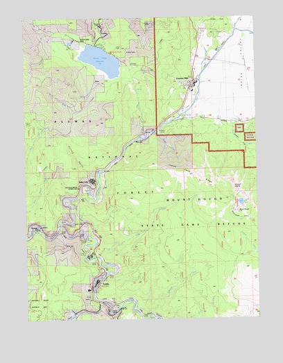
Crescent Mills, CA USGS Topographic Map
Click on map above to begin viewing in our Map Viewer.

This topographic map contains these locations and features:
Feature Name Type Latitude Longitude GNIS ID View Map
Arcadia MineMineN40.1221°W120.9586°256307View Map
Arlington BridgeBridgeN40.0821°W120.9205°256320View Map
Arlington HeightsSummitN40.0557°W120.8902°256321View Map
Bellas CreekStreamN40.0974°W120.9608°256810View Map
Bellas FlatFlatN40.0993°W120.9602°256811View Map
Bidwell Lake 273 DamDamN40.1132°W120.9627°1663811View Map
Big Blackhawk CreekStreamN40.0027°W120.9547°256891View Map
Butterfly CreekStreamN40.0066°W120.9625°257778View Map
Butterfly ValleyValleyN40.0068°W120.9616°257780View Map
Butterfly Valley Botanical AreaAreaN40.0057°W120.9950°276047View Map
Camp Wallace AlexanderLocaleN40.0263°W120.9655°257907View Map
Cashman CreekStreamN40.0035°W120.9419°258045View Map
Cherokee MineMineN40.1046°W120.9391°258239View Map
Clear CreekStreamN40.0254°W120.9613°258424View Map
Crescent MillsPopulated PlaceN40.0966°W120.9108°1655937View Map
Crescent Mills Census Designated PlaceCensusN40.1007°W120.9217°2407679View Map
Crescent Mills Fire Protection DistrictBuildingN40.0967°W120.9117°2621927View Map
Crescent Mills Post OfficePost OfficeN40.0956°W120.9120°1701347View Map
Crystal LakeLakeN40.0479°W120.8841°258960View Map
Curtis RavineValleyN40.0599°W120.9619°258997View Map
Deer Vally Golf LinksLocaleN40.0868°W120.9138°1701349View Map
Dixie CreekStreamN40.0760°W120.9338°259402View Map
Forgay PointCapeN40.1238°W120.8952°260263View Map
Hough CreekStreamN40.0902°W120.9077°261562View Map
Hunodim PeakSummitN40.1124°W120.9330°1852147View Map
Indian CreekStreamN40.0379°W120.9827°261733View Map
Indian FallsPopulated PlaceN40.0568°W120.9638°1656088View Map
Indian FallsFallsN40.0616°W120.9616°1666182View Map
Indian Falls Census Designated PlaceCensusN40.0588°W120.9803°2408419View Map
Indian Falls RidgeRidgeN40.0568°W120.9066°261741View Map
Indian ValleyValleyN40.0810°W120.8858°261773View Map
KeddiePopulated PlaceN40.0149°W120.9611°1656106View Map
Keddie Census Designated PlaceCensusN40.0059°W120.9525°2408465View Map
KQNC-FM (Quincy)TowerN40.0599°W120.9138°1663015View Map
MoccasinPopulated PlaceN40.0768°W120.9363°1656170View Map
Moccasin CreekStreamN40.0766°W120.9286°263717View Map
Monitor MineMineN40.0810°W120.9983°263740View Map
Mount HoughSummitN40.0446°W120.8861°261565View Map
Mount Hough State Game RefugeParkN40.0207°W120.9052°1666186View Map
PaxtonPopulated PlaceN40.0379°W120.9950°1656210View Map
Round Valley (historical)Populated PlaceN40.1157°W120.9677°1666190View Map
Round Valley CampgroundLocaleN40.1107°W120.9533°1666191View Map
Round Valley ReservoirReservoirN40.1138°W120.9622°265629View Map
Soda CreekStreamN40.0382°W120.9980°267362View Map
Spanish CreekStreamN40.0382°W120.9830°267548View Map
Standart MineMineN40.1218°W120.9313°267665View Map
Tunnel Number 26TunnelN40.0360°W120.9816°1666199View Map
Tunnel Number 27TunnelN40.0349°W120.9727°1666200View Map
Tunnel Number 28TunnelN40.0324°W120.9711°1666201View Map
Tunnel Number 29TunnelN40.0271°W120.9697°1666202View Map
Tunnel Number 30TunnelN40.0238°W120.9636°1666203View Map
Tunnel Number 31TunnelN40.0207°W120.9597°1666204View Map
Tunnel Number 32TunnelN40.0179°W120.9572°1666205View Map
Tunnel Number 33TunnelN40.0018°W120.9372°1666206View Map
Wolf CreekStreamN40.1193°W120.8833°269267View Map

Note: Coordinates in the location and feature list above are referenced to NAD83 datum.


Copyright (C) 2008-2025 Ryan Niemi / Sunset Dynamics ... All Rights Reserved