TopoQuest Logo
Do you find TopoQuest useful?
Help keep TopoQuest running and adding new maps/features by donating!
Bitcoin:  19c7KJd3qBynnjoSw5npx9KScwjBe4ifkT
Litecoin:  LXs6TkuXGGXo1vDsWCkWVdjQX94eUKd6ui
Home View Maps Find Maps Find Places Resources & Links


Meadow Valley, California Topographic Map

USGS Map Title: Meadow Valley, CA
USGS Map MRC: 39121H1
DRG (GeoTIFF) Download: o39121h1.tif


Neighboring USGS Topographic Map Quads:


  Caribou, CA  
40121A2
 

  Twain, CA  
40121A1
 

  Crescent Mills, CA  
40120A8
 

  Bucks Lake, CA  
39121H2
 

  Meadow Valley, CA  
39121H1
 

  Quincy, CA  
39120H8
 

  Haskins Valley, CA  
39121G2
 

  Dogwood Peak, CA  
39121G1
 

  Onion Valley, CA  
39120G8


Map MRC Location:

N40°
W122°
N40°
W121°
H8 H7 H6 H5 H4 H3 H2 H1
G8 G7 G6 G5 G4 G3 G2 G1
F8 F7 F6 F5 F4 F3 F2 F1
E8 E7 E6 E5 E4 E3 E2 E1
D8 D7 D6 D5 D4 D3 D2 D1
C8 C7 C6 C5 C4 C3 C2 C1
B8 B7 B6 B5 B4 B3 B2 B1
A8 A7 A6 A5 A4 A3 A2 A1
N39°
W122°
N39°
W121°

Meadow Valley, CA USGS 1:24K Topographic Map Preview:
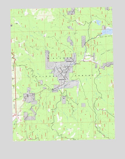
Meadow Valley, CA USGS Topographic Map
Click on map above to begin viewing in our Map Viewer.

This topographic map contains these locations and features:
Feature Name Type Latitude Longitude GNIS ID View Map
Bean CreekStreamN39.9668°W121.0852°256611View Map
Bean HillSummitN39.9738°W121.0866°1666485View Map
Big CreekStreamN39.9196°W121.0902°256910View Map
Black GulchValleyN39.9260°W121.0886°257118View Map
Boring Mill RavineValleyN39.9185°W121.1100°257363View Map
Bucks SummitSummitN39.8999°W121.1186°1658160View Map
Burton GulchValleyN39.9541°W121.0819°257739View Map
Burton RidgeRidgeN39.9563°W121.1025°1666490View Map
Clear CreekStreamN39.9260°W121.0897°258432View Map
Deadwood CreekStreamN39.9235°W121.0847°259148View Map
Dean Valley Reservoir (historical)ReservoirN39.8904°W121.0236°1723905View Map
Deanes ValleyBasinN39.8885°W121.0238°259165View Map
Deer CreekStreamN39.9171°W121.0213°266631View Map
Eagle GulchValleyN39.9082°W121.0925°259659View Map
East Branch Big CreekStreamN39.8993°W121.0975°259686View Map
East Branch Rock CreekStreamN39.9013°W121.0216°259693View Map
East Branch Schneider CreekStreamN39.9057°W121.0702°259694View Map
Edmanton (historical)Populated PlaceN39.9021°W121.1047°1723906View Map
Gopher HillSummitN39.9529°W121.0291°1658638View Map
Greens FlatFlatN39.9574°W121.0805°1666500View Map
Grub FlatFlatN39.9304°W121.0650°1723907View Map
Jacks Meadow CreekStreamN39.9532°W121.1180°261873View Map
Little Schneider CreekStreamN39.9291°W121.0427°262717View Map
Meadow ValleyPopulated PlaceN39.9296°W121.0608°1659096View Map
Meadow ValleyBasinN39.9377°W121.0616°1666515View Map
Meadow Valley Census Designated PlaceCensusN39.9323°W121.0831°2408809View Map
Meadow Valley CreekStreamN39.9332°W121.0344°263427View Map
Meadow Valley Fire Protection DistrictBuildingN39.9388°W121.0589°2622090View Map
Meadow Valley Post OfficePost OfficeN39.9366°W121.0604°2783802View Map
Meadow Valley SchoolSchoolN39.9304°W121.0608°1701380View Map
Mulligan SlideSlopeN39.9868°W121.1169°1666519View Map
Pineleaf CreekStreamN39.9466°W121.0488°264786View Map
Pineleaf MineMineN39.9768°W121.0491°264787View Map
Rock CreekStreamN39.9171°W121.0205°265475View Map
Rock CreekStreamN39.9477°W121.0205°265476View Map
Rock Creek CampgroundLocaleN39.9010°W121.0238°1666522View Map
Schneider CreekStreamN39.9249°W121.0619°265913View Map
Silver CreekStreamN39.9429°W121.0708°266181View Map
Silver Creek (historical)Populated PlaceN39.9443°W121.0716°1723908View Map
Slate CreekStreamN39.9424°W121.0172°265763View Map
Smith LakeReservoirN39.9857°W121.0191°266330View Map
Smith Lake DamDamN39.9857°W121.0191°1664759View Map
Snake LakeLakeN39.9771°W121.0063°267292View Map
Snake Lake ValleyValleyN39.9735°W121.0150°267294View Map
South Fork Rock CreekStreamN39.9013°W121.0222°267496View Map
Spanish RanchPopulated PlaceN39.9507°W121.0572°1659835View Map
Tamarack FlatFlatN39.8757°W121.0483°1666527View Map
Taylor GulchValleyN39.9202°W121.0791°268104View Map
University of California Forestry CampLocaleN39.9188°W121.0627°268595View Map
Wapaunsie CreekStreamN39.9502°W121.0377°268774View Map
Whitlock RavineValleyN39.9504°W121.0169°269041View Map

Note: Coordinates in the location and feature list above are referenced to NAD83 datum.


Copyright (C) 2008-2024 Ryan Niemi / Sunset Dynamics ... All Rights Reserved