TopoQuest Logo
Do you find TopoQuest useful?
Help keep TopoQuest running and adding new maps/features by donating!
Bitcoin:  19c7KJd3qBynnjoSw5npx9KScwjBe4ifkT
Litecoin:  LXs6TkuXGGXo1vDsWCkWVdjQX94eUKd6ui
Home View Maps Find Maps Find Places Resources & Links


Twain, California Topographic Map

USGS Map Title: Twain, CA
USGS Map MRC: 40121A1
DRG (GeoTIFF) Download: o40121a1.tif


Neighboring USGS Topographic Map Quads:


  Almanor, CA  
40121B2
 

  Canyondam, CA  
40121B1
 

  Greenville, CA  
40120B8
 

  Caribou, CA  
40121A2
 

  Twain, CA  
40121A1
 

  Crescent Mills, CA  
40120A8
 

  Bucks Lake, CA  
39121H2
 

  Meadow Valley, CA  
39121H1
 

  Quincy, CA  
39120H8


Map MRC Location:

N41°
W122°
N41°
W121°
H8 H7 H6 H5 H4 H3 H2 H1
G8 G7 G6 G5 G4 G3 G2 G1
F8 F7 F6 F5 F4 F3 F2 F1
E8 E7 E6 E5 E4 E3 E2 E1
D8 D7 D6 D5 D4 D3 D2 D1
C8 C7 C6 C5 C4 C3 C2 C1
B8 B7 B6 B5 B4 B3 B2 B1
A8 A7 A6 A5 A4 A3 A2 A1
N40°
W122°
N40°
W121°

Twain, CA USGS 1:24K Topographic Map Preview:
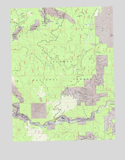
Twain, CA USGS Topographic Map
Click on map above to begin viewing in our Map Viewer.

This topographic map contains these locations and features:
Feature Name Type Latitude Longitude GNIS ID View Map
Barker GulchValleyN40.1102°W121.1158°218671View Map
Bear CreekStreamN40.1113°W121.0730°218812View Map
Berry CreekStreamN40.0163°W121.0958°233492View Map
Bey Cha RavineValleyN40.0207°W121.0805°222384View Map
Big Flat CemeteryCemeteryN40.1077°W121.0994°1666389View Map
Bullfrog RavineValleyN40.0821°W121.0366°220130View Map
China BarBarN40.0960°W121.1230°1666390View Map
Clear CreekStreamN40.0963°W121.1238°221192View Map
Cold SpringSpringN40.1082°W121.0286°1666391View Map
Cold Spring HillSummitN40.1160°W121.0433°1666392View Map
Comeback MineMineN40.1082°W121.0319°1666393View Map
Cow CreekStreamN40.1054°W121.0280°221692View Map
Dark RavineValleyN40.0979°W121.0327°222025View Map
Davis CreekStreamN40.1235°W121.0888°222048View Map
Dutch CreekStreamN40.0210°W121.0291°222759View Map
Dutch Hill MineMineN40.1191°W121.1036°222772View Map
Dutch Hill TunnelMineN40.1171°W121.1113°1666394View Map
Eagle RockPillarN40.0566°W121.1202°222830View Map
East Branch Soda CreekStreamN40.0438°W121.0027°222864View Map
Glazier MineMineN40.1107°W121.0875°1666395View Map
Grays FlatPopulated PlaceN40.0177°W121.0636°1658660View Map
Hallsted CampgroundLocaleN40.0174°W121.0741°277117View Map
Hallsted FlatFlatN40.0182°W121.0747°252364View Map
Hambly RavineValleyN40.0063°W121.0675°224828View Map
Hazard MineMineN40.1099°W121.0683°1666396View Map
Hot SpringsPopulated PlaceN40.0188°W121.0338°1660048View Map
Hot Springs RavineValleyN40.0210°W121.0366°225678View Map
Johnson RavineValleyN40.0441°W121.0822°226315View Map
Kingsbury RavineValleyN40.0243°W121.0686°226610View Map
Kirkham RavineValleyN40.1104°W121.0805°226630View Map
Logan TunnelMineN40.1202°W121.1125°1666397View Map
Long ValleyValleyN40.0999°W121.0297°227617View Map
Lucky Chance MineMineN40.1082°W121.0822°1666398View Map
Marion RavineValleyN40.1032°W121.0922°228105View Map
Mary Cameron MineMineN40.1066°W121.0927°1666399View Map
Meeker BarBarN40.0991°W121.1166°1666400View Map
Middle RavineValleyN40.0441°W121.0213°228611View Map
Mill CreekStreamN40.0166°W121.0794°228697View Map
Muggins CreekStreamN40.1004°W121.1122°229283View Map
Onion FlatFlatN40.0750°W121.0283°230053View Map
Paxton Census Designated PlaceCensusN40.0336°W121.0026°2409040View Map
Paxton SidingLocaleN40.0338°W121.0036°1666401View Map
Perini PlaceLocaleN40.1146°W121.1247°1666402View Map
Providence Hill MineMineN40.0652°W121.0477°231075View Map
Rich GulchValleyN40.0327°W121.1208°231540View Map
Rush CreekStreamN40.0246°W121.1236°232021View Map
Rush Creek HillSummitN40.0654°W121.1177°1659558View Map
Schneider RavineValleyN40.0613°W121.0605°232659View Map
SenecaPopulated PlaceN40.1104°W121.0847°1659625View Map
Sunnyside MineMineN40.1002°W121.1244°235789View Map
Swiss MineMineN40.1116°W121.1150°1666403View Map
Tunnel Number 26TunnelN40.0132°W121.0880°1666404View Map
TwainPopulated PlaceN40.0202°W121.0719°224823View Map
Twain Census Designated PlaceCensusN40.0355°W121.0404°2409369View Map
Twain Post OfficePost OfficeN40.0191°W121.0706°2783814View Map
Twain SidingLocaleN40.0168°W121.0477°1666405View Map
Twelvemile RavineValleyN40.0277°W121.1244°236678View Map
VirgiliaPopulated PlaceN40.0185°W121.1055°237105View Map
Virgilia MineMineN40.0252°W121.1211°1666406View Map
West Branch Soda CreekStreamN40.0460°W121.0077°237438View Map
White Horse MineMineN40.1032°W121.0294°1666407View Map
York CreekStreamN40.0210°W121.1069°238268View Map

Note: Coordinates in the location and feature list above are referenced to NAD83 datum.


Copyright (C) 2008-2024 Ryan Niemi / Sunset Dynamics ... All Rights Reserved