TopoQuest Logo
Do you find TopoQuest useful?
Help keep TopoQuest running and adding new maps/features by donating!
Bitcoin:  19c7KJd3qBynnjoSw5npx9KScwjBe4ifkT
Litecoin:  LXs6TkuXGGXo1vDsWCkWVdjQX94eUKd6ui
Home View Maps Find Maps Find Places Resources & Links


Crestwood, Kentucky Topographic Map

USGS Map Title: Crestwood, KY
USGS Map MRC: 38085C4
DRG (GeoTIFF) Download: o38085c4.tif


Neighboring USGS Topographic Map Quads:


  Owen, IN  
38085D5
 

  La Grange, KY  
38085D4
 

  Smithfield, KY  
38085D3
 

  Anchorage, KY  
38085C5
 

  Crestwood, KY  
38085C4
 

  Ballardsville, KY  
38085C3
 

  Jeffersontown, KY  
38085B5
 

  Fisherville, KY  
38085B4
 

  Simpsonville, KY  
38085B3


Map MRC Location:

N39°
W86°
N39°
W85°
H8 H7 H6 H5 H4 H3 H2 H1
G8 G7 G6 G5 G4 G3 G2 G1
F8 F7 F6 F5 F4 F3 F2 F1
E8 E7 E6 E5 E4 E3 E2 E1
D8 D7 D6 D5 D4 D3 D2 D1
C8 C7 C6 C5 C4 C3 C2 C1
B8 B7 B6 B5 B4 B3 B2 B1
A8 A7 A6 A5 A4 A3 A2 A1
N38°
W86°
N38°
W85°

Crestwood, KY USGS 1:24K Topographic Map Preview:
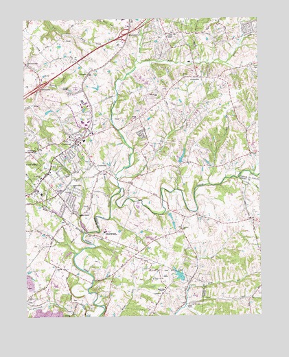
Crestwood, KY USGS Topographic Map
Click on map above to begin viewing in our Map Viewer.

This topographic map contains these locations and features:
Feature Name Type Latitude Longitude GNIS ID View Map
Ashers RunStreamN38.3081°W85.4505°486088View Map
AvocaPopulated PlaceN38.2592°W85.4986°486158View Map
BeckleyPopulated PlaceN38.2509°W85.4763°507470View Map
BrownsboroPopulated PlaceN38.3562°W85.4983°488041View Map
Buckner Post OfficePost OfficeN38.3711°W85.4435°2460336View Map
Butler BranchStreamN38.2809°W85.4778°2743828View Map
CenterfieldPopulated PlaceN38.3501°W85.4075°489274View Map
Centerfield Elementary SchoolSchoolN38.3683°W85.4224°2612102View Map
City of CrestwoodCivilN38.3308°W85.4752°2404155View Map
City of Park Lake (historical)CivilN38.3453°W85.4736°2404477View Map
City of Pewee ValleyCivilN38.3105°W85.4896°2404509View Map
Community Presbyterian ChurchChurchN38.2846°W85.4896°2459771View Map
Confederate CemeteryCemeteryN38.3030°W85.4769°489953View Map
CrestwoodPopulated PlaceN38.3242°W85.4725°490334View Map
Crestwood Post OfficePost OfficeN38.3266°W85.4737°2460340View Map
Crestwood Station Shopping and Business CenterLocaleN38.3396°W85.4672°2460236View Map
Currys ForkStreamN38.3040°W85.4491°490506View Map
Dalton RunStreamN38.2540°W85.4152°1888890View Map
Elder Park (historical)Populated PlaceN38.3691°W85.4078°2742541View Map
Flat Rock (historical)Populated PlaceN38.2862°W85.4164°2567212View Map
Flat Rock CemeteryCemeteryN38.2867°W85.4169°492207View Map
Flat Rock Christian Church (historical)ChurchN38.2864°W85.4166°2567213View Map
FloydsburgPopulated PlaceN38.3112°W85.4597°492279View Map
GlenarmPopulated PlaceN38.3537°W85.4630°508098View Map
Junkins RunStreamN38.3078°W85.3861°495555View Map
Kavanaugh Life Enrichment CenterSchoolN38.3145°W85.4694°495580View Map
Kentucky Correctional Institution for WomenBuildingN38.2858°W85.4574°2567728View Map
Kentucky Correctional Institution for WomenBuildingN38.2858°W85.4571°2567228View Map
Lang RunStreamN38.2628°W85.4133°495979View Map
Long Run Baptist ChurchChurchN38.2694°W85.4339°497143View Map
Long Run CemeteryCemeteryN38.2548°W85.4133°1877556View Map
Long Run ParkParkN38.2673°W85.4211°497144View Map
Mount Tabor United Methodist ChurchChurchN38.3505°W85.4146°498870View Map
North Fork Currys ForkStreamN38.3573°W85.4402°499547View Map
Park LakePopulated PlaceN38.3451°W85.4733°1669490View Map
Pewee ValleyPopulated PlaceN38.3106°W85.4875°500496View Map
Pewee Valley CemeteryCemeteryN38.3042°W85.4757°500497View Map
Pewee Valley Fire DepartmentBuildingN38.3027°W85.4940°2636739View Map
Pewee Valley Police DepartmentBuildingN38.3103°W85.4886°2767786View Map
Pewee Valley Post OfficePost OfficeN38.3075°W85.4928°2460363View Map
Pewee Valley SanitariumHospitalN38.3015°W85.4911°500498View Map
Pewee Valley TempleChurchN38.3023°W85.4822°500499View Map
Pleasant Grove ChurchChurchN38.2587°W85.4977°500831View Map
Pleasant Hill CemeteryCemeteryN38.3439°W85.4286°500844View Map
RollingtonPopulated PlaceN38.3195°W85.4975°502302View Map
Saint Aloysius SchoolSchoolN38.3084°W85.4913°502566View Map
Saint James Episcopal ChurchChurchN38.3128°W85.4847°502635View Map
Saint Patrick Catholic ChurchChurchN38.2511°W85.4755°2460498View Map
South Fork Currys ForkStreamN38.3570°W85.4397°503919View Map
South Oldham Fire DepartmentBuildingN38.3317°W85.4625°2636332View Map
Tater RunStreamN38.2545°W85.4152°504975View Map
Timmons Field Airport (historical)AirportN38.2842°W85.4726°517473View Map
WHAS-AM (Louisville)TowerN38.2612°W85.4286°517856View Map
Woodledge Farm AirportAirportN38.2834°W85.4820°517358View Map

Note: Coordinates in the location and feature list above are referenced to NAD83 datum.


Copyright (C) 2008-2025 Ryan Niemi / Sunset Dynamics ... All Rights Reserved