TopoQuest Logo
Do you find TopoQuest useful?
Help keep TopoQuest running and adding new maps/features by donating!
Bitcoin:  19c7KJd3qBynnjoSw5npx9KScwjBe4ifkT
Litecoin:  LXs6TkuXGGXo1vDsWCkWVdjQX94eUKd6ui
Home View Maps Find Maps Find Places Resources & Links


La Grange, Kentucky Topographic Map

USGS Map Title: La Grange, KY
USGS Map MRC: 38085D4
DRG (GeoTIFF) Download: o38085d4.tif


Neighboring USGS Topographic Map Quads:


  New Washington, IN  
38085E5
 

  Bethlehem, IN  
38085E4
 

  Bedford, KY  
38085E3
 

  Owen, IN  
38085D5
 

  La Grange, KY  
38085D4
 

  Smithfield, KY  
38085D3
 

  Anchorage, KY  
38085C5
 

  Crestwood, KY  
38085C4
 

  Ballardsville, KY  
38085C3


Map MRC Location:

N39°
W86°
N39°
W85°
H8 H7 H6 H5 H4 H3 H2 H1
G8 G7 G6 G5 G4 G3 G2 G1
F8 F7 F6 F5 F4 F3 F2 F1
E8 E7 E6 E5 E4 E3 E2 E1
D8 D7 D6 D5 D4 D3 D2 D1
C8 C7 C6 C5 C4 C3 C2 C1
B8 B7 B6 B5 B4 B3 B2 B1
A8 A7 A6 A5 A4 A3 A2 A1
N38°
W86°
N38°
W85°

La Grange, KY USGS 1:24K Topographic Map Preview:
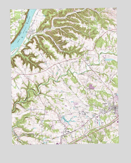
La Grange, KY USGS Topographic Map
Click on map above to begin viewing in our Map Viewer.

This topographic map contains these locations and features:
Feature Name Type Latitude Longitude GNIS ID View Map
Anita SpringsSpringN38.4012°W85.4030°2742538View Map
Ash RunStreamN38.4421°W85.4103°486075View Map
Baptist Health La GrangeHospitalN38.3951°W85.3760°2460194View Map
Brush CreekStreamN38.4403°W85.4283°488068View Map
BucknerPopulated PlaceN38.3837°W85.4400°488281View Map
Buckner Census Designated PlaceCensusN38.3867°W85.4503°2402727View Map
Caney ForkStreamN38.4756°W85.4700°488858View Map
Cedar CreekStreamN38.4212°W85.4672°489177View Map
Cedar PointPopulated PlaceN38.4078°W85.4777°507677View Map
Cedar PointCliffN38.4226°W85.4663°489235View Map
Circle Dart LakeReservoirN38.4937°W85.4597°489519View Map
City of La GrangeCivilN38.3987°W85.3750°2404848View Map
Darby ForkStreamN38.3820°W85.4927°490589View Map
DemplytownPopulated PlaceN38.3845°W85.4744°507844View Map
Dunbar BranchStreamN38.4592°W85.4949°2742540View Map
Dunbar HollowValleyN38.4590°W85.4947°491288View Map
Eighteenmile ChurchChurchN38.4573°W85.4083°491593View Map
Eighteenmile CreekStreamN38.4751°W85.4819°491594View Map
Eighteenmile IslandIslandN38.4598°W85.4991°491595View Map
Garrett BranchStreamN38.4823°W85.4494°492719View Map
Green HillSummitN38.4779°W85.4544°2742542View Map
GreenhavenPopulated PlaceN38.4453°W85.4541°508131View Map
Harris BranchStreamN38.4967°W85.4216°493799View Map
Kentucky State ReformatoryBuildingN38.4034°W85.4159°2767761View Map
La GrangePopulated PlaceN38.4076°W85.3788°495884View Map
La Grange DivisionCivilN38.4233°W85.3890°1937095View Map
La Grange Elementary SchoolSchoolN38.4048°W85.3866°2460691View Map
La Grange Fire and Rescue Department Station 1BuildingN38.4111°W85.3788°2636459View Map
La Grange Fire and Rescue Department Station 2BuildingN38.3881°W85.4280°2636421View Map
La Grange Fire and Rescue Department Station 3BuildingN38.4601°W85.4100°2636670View Map
La Grange Police DepartmentBuildingN38.4075°W85.3845°2767762View Map
La Grange Post OfficePost OfficeN38.4008°W85.3777°2460354View Map
La Grange Square Shopping CenterLocaleN38.4050°W85.3765°2460264View Map
Lake LotawataReservoirN38.3768°W85.4617°497200View Map
Luther Luckett Correctional ComplexBuildingN38.4124°W85.4254°2767774View Map
North Fork Cedar CreekStreamN38.4212°W85.4625°499545View Map
OldhamPopulated PlaceN38.4976°W85.4211°508744View Map
Oldham CountyCivilN38.3994°W85.4484°516939View Map
Oldham County Emergency Medical ServicesBuildingN38.3879°W85.4287°2719147View Map
Oldham County Police DepartmentBuildingN38.3957°W85.4417°2767423View Map
Oldham County Sheriff's OfficeBuildingN38.4081°W85.3798°2767464View Map
Reformatory LakeReservoirN38.3959°W85.4352°501712View Map
Roederer Correctional ComplexBuildingN38.4032°W85.4298°2767792View Map
Russell CornerPopulated PlaceN38.4515°W85.4116°508988View Map
Smith RidgeRidgeN38.4726°W85.4330°503805View Map
Sycamore RunStreamN38.4776°W85.4625°504888View Map
Valley of Rest CemeteryCemeteryN38.4043°W85.3751°505947View Map
WAVE-TV (Louisville)TowerN38.4565°W85.4244°518057View Map
WestportPopulated PlaceN38.4790°W85.4750°506501View Map
Westport Census Designated PlaceCensusN38.4874°W85.4753°2583509View Map
Westport Post OfficePost OfficeN38.4785°W85.4752°2460374View Map
Westport Voluntary Fire DepartmentBuildingN38.4787°W85.4716°2636595View Map

Note: Coordinates in the location and feature list above are referenced to NAD83 datum.


Copyright (C) 2008-2025 Ryan Niemi / Sunset Dynamics ... All Rights Reserved