TopoQuest Logo
Do you find TopoQuest useful?
Help keep TopoQuest running and adding new maps/features by donating!
Bitcoin:  19c7KJd3qBynnjoSw5npx9KScwjBe4ifkT
Litecoin:  LXs6TkuXGGXo1vDsWCkWVdjQX94eUKd6ui
Home View Maps Find Maps Find Places Resources & Links


Crisp, Missouri Topographic Map

USGS Map Title: Crisp, MO
USGS Map MRC: 37093E7
DRG (GeoTIFF) Download: o37093e7.tif


Neighboring USGS Topographic Map Quads:


  Wagoner, MO  
37093F8
 

  Stockton, MO  
37093F7
 

  Bearcreek, MO  
37093F6
 

  Cedarville, MO  
37093E8
 

  Crisp, MO  
37093E7
 

  Bona, MO  
37093E6
 

  Lockwood, MO  
37093D8
 

  Greenfield, MO  
37093D7
 

  Dadeville, MO  
37093D6


Map MRC Location:

N38°
W94°
N38°
W93°
H8 H7 H6 H5 H4 H3 H2 H1
G8 G7 G6 G5 G4 G3 G2 G1
F8 F7 F6 F5 F4 F3 F2 F1
E8 E7 E6 E5 E4 E3 E2 E1
D8 D7 D6 D5 D4 D3 D2 D1
C8 C7 C6 C5 C4 C3 C2 C1
B8 B7 B6 B5 B4 B3 B2 B1
A8 A7 A6 A5 A4 A3 A2 A1
N37°
W94°
N37°
W93°

Crisp, MO USGS 1:24K Topographic Map Preview:
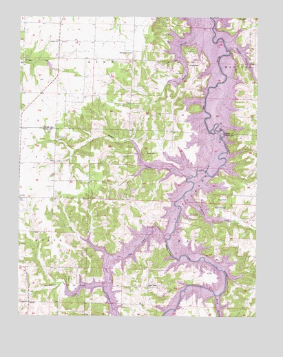
Crisp, MO USGS Topographic Map
Click on map above to begin viewing in our Map Viewer.

This topographic map contains these locations and features:
Feature Name Type Latitude Longitude GNIS ID View Map
Acord CemeteryCemeteryN37.5539°W93.8572°713131View Map
Arcola Post OfficePost OfficeN37.5485°W93.8732°2779547View Map
Bald HillSummitN37.5681°W93.8085°713585View Map
Bald Mound CemeteryCemeteryN37.5456°W93.7658°713593View Map
Birch BranchStreamN37.5089°W93.7710°714255View Map
Bishop Grove ChurchChurchN37.6100°W93.8160°714272View Map
Burns LakeReservoirN37.6042°W93.8593°763130View Map
Burns Lake DamDamN37.6050°W93.8602°763129View Map
Cave School (historical)SchoolN37.5039°W93.8108°746260View Map
Cave SpringSpringN37.5589°W93.8130°715536View Map
Cave Spring Church (historical)ChurchN37.5595°W93.8138°729856View Map
Chapel HillSummitN37.6056°W93.7841°715727View Map
Concord School (historical)SchoolN37.6153°W93.8541°746242View Map
CrispPopulated PlaceN37.5698°W93.7880°740777View Map
Crisp BridgeBridgeN37.5781°W93.7758°755042View Map
Crisp Cemetery (historical)CemeteryN37.5678°W93.7749°716503View Map
Crisp School (historical)SchoolN37.5700°W93.7877°746263View Map
Downs BluffCliffN37.5584°W93.7730°717036View Map
Duncan CemeteryCemeteryN37.5150°W93.8296°717177View Map
Glen TownPopulated PlaceN37.5123°W93.8069°740872View Map
Glen Town Census Designated PlaceCensusN37.5066°W93.8067°2587073View Map
Googer CreekStreamN37.5581°W93.7858°718580View Map
Greaser CreekStreamN37.5125°W93.8302°718770View Map
Hartley BranchStreamN37.6117°W93.7649°719181View Map
Hawker Point Public Use AreaParkN37.6064°W93.7813°742718View Map
KaderBuildingN37.6150°W93.8455°745787View Map
Liberty CemeteryCemeteryN37.6014°W93.7941°720957View Map
Mill BluffCliffN37.5248°W93.7744°722318View Map
Mount Zion School (historical)SchoolN37.5581°W93.8160°746261View Map
Mutton CreekStreamN37.5503°W93.7883°723090View Map
Mutton Creek Public Use AreaParkN37.5420°W93.7802°742717View Map
NeolaPopulated PlaceN37.5056°W93.8697°741094View Map
Osborn ChurchChurchN37.6145°W93.8549°723863View Map
Prairie View School (historical)SchoolN37.5887°W93.8519°746243View Map
Ross CemeteryCemeteryN37.6106°W93.7869°725577View Map
RowlandPopulated PlaceN37.5987°W93.8160°740056View Map
Rowland School (historical)SchoolN37.5931°W93.8158°746245View Map
Ruark BluffCliffN37.5273°W93.7960°725648View Map
Scott HillSummitN37.5487°W93.7719°726149View Map
SeybertPopulated PlaceN37.5187°W93.7738°741258View Map
Shaw School (historical)SchoolN37.5334°W93.7666°746262View Map
Sons CreekStreamN37.5339°W93.7955°726690View Map
Sorters BluffCliffN37.6056°W93.7616°726693View Map
Stony Point School (historical)SchoolN37.6064°W93.8019°746244View Map
Sycamore BridgeBridgeN37.6131°W93.7674°755424View Map
Township of SacCivilN37.5206°W93.7822°766560View Map
UmberPopulated PlaceN37.6248°W93.7555°727951View Map
Umber View HeightsPopulated PlaceN37.6237°W93.8035°1669606View Map
Village of Umber View HeightsCivilN37.6234°W93.8036°2400018View Map
Wasson BluffCliffN37.6220°W93.7719°728389View Map

Note: Coordinates in the location and feature list above are referenced to NAD83 datum.


Copyright (C) 2008-2024 Ryan Niemi / Sunset Dynamics ... All Rights Reserved