TopoQuest Logo
Do you find TopoQuest useful?
Help keep TopoQuest running and adding new maps/features by donating!
Bitcoin:  19c7KJd3qBynnjoSw5npx9KScwjBe4ifkT
Litecoin:  LXs6TkuXGGXo1vDsWCkWVdjQX94eUKd6ui
Home View Maps Find Maps Find Places Resources & Links


Greenfield, Missouri Topographic Map

USGS Map Title: Greenfield, MO
USGS Map MRC: 37093D7
DRG (GeoTIFF) Download: o37093d7.tif


Neighboring USGS Topographic Map Quads:


  Cedarville, MO  
37093E8
 

  Crisp, MO  
37093E7
 

  Bona, MO  
37093E6
 

  Lockwood, MO  
37093D8
 

  Greenfield, MO  
37093D7
 

  Dadeville, MO  
37093D6
 

  Kings Point, MO  
37093C8
 

  South Greenfield, MO  
37093C7
 

  Everton, MO  
37093C6


Map MRC Location:

N38°
W94°
N38°
W93°
H8 H7 H6 H5 H4 H3 H2 H1
G8 G7 G6 G5 G4 G3 G2 G1
F8 F7 F6 F5 F4 F3 F2 F1
E8 E7 E6 E5 E4 E3 E2 E1
D8 D7 D6 D5 D4 D3 D2 D1
C8 C7 C6 C5 C4 C3 C2 C1
B8 B7 B6 B5 B4 B3 B2 B1
A8 A7 A6 A5 A4 A3 A2 A1
N37°
W94°
N37°
W93°

Greenfield, MO USGS 1:24K Topographic Map Preview:
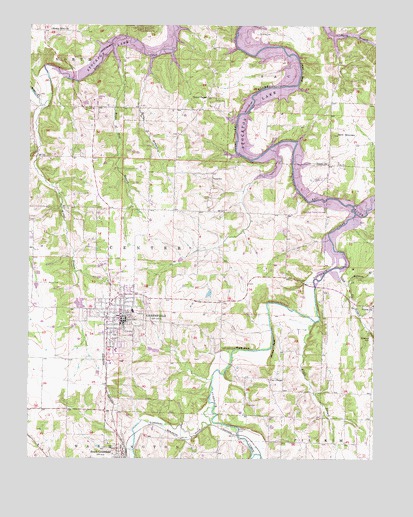
Greenfield, MO USGS Topographic Map
Click on map above to begin viewing in our Map Viewer.

This topographic map contains these locations and features:
Feature Name Type Latitude Longitude GNIS ID View Map
Boggy BranchStreamN37.4145°W93.7716°714482View Map
Bracket HillSummitN37.4098°W93.7513°714605View Map
Carr ChapelChurchN37.3981°W93.7883°715423View Map
Cave School (historical)SchoolN37.4364°W93.7797°746285View Map
City of GreenfieldCivilN37.4162°W93.8432°2394990View Map
Dade CountyCivilN37.4320°W93.8503°758483View Map
Dade County Sheriff's OfficeBuildingN37.4152°W93.8393°2752232View Map
Danley (historical)LocaleN37.3842°W93.8108°740394View Map
Eagles Point and Red Barn Village Airpark (historical)AirportN37.4792°W93.8516°758705View Map
Fairview School (historical)SchoolN37.4473°W93.8313°746284View Map
Fanning CemeteryCemeteryN37.4978°W93.7930°717839View Map
Fiddlers FordPopulated PlaceN37.3839°W93.7991°740850View Map
Friend BridgeBridgeN37.4520°W93.7774°755187View Map
Friend ChurchChurchN37.4600°W93.7672°718227View Map
GreenfieldPopulated PlaceN37.4153°W93.8410°718821View Map
Greenfield CemeteryCemeteryN37.4181°W93.8351°2681486View Map
Greenfield Elementary SchoolSchoolN37.4178°W93.8375°2710687View Map
Greenfield Fire DepartmentBuildingN37.4168°W93.8470°2621688View Map
Greenfield High SchoolSchoolN37.4161°W93.8430°2710686View Map
Greenfield Post OfficePost OfficeN37.4143°W93.8401°2779487View Map
Greenfield Public Use AreaParkN37.4475°W93.7716°742886View Map
Grider BranchStreamN37.4909°W93.8308°718873View Map
Holman BranchStreamN37.4253°W93.7599°719723View Map
Hoyle BluffCliffN37.4070°W93.8008°719937View Map
Limestone CreekStreamN37.3898°W93.8083°721072View Map
Lone Jack School (historical)SchoolN37.4623°W93.8605°746281View Map
Lotus School (historical)SchoolN37.3845°W93.7513°746287View Map
Lynn BranchStreamN37.4303°W93.7644°729925View Map
Mount Olive ChurchChurchN37.4989°W93.8674°722814View Map
Rector Lake DamDamN37.4784°W93.8552°763480View Map
Right of Way BranchStreamN37.4931°W93.8452°725305View Map
Rose CemeteryCemeteryN37.4600°W93.7644°725557View Map
Sand MountainSummitN37.4687°W93.7652°726014View Map
Sand Mountain School (historical)SchoolN37.4817°W93.7658°746282View Map
Shady Grove School (historical)SchoolN37.3948°W93.7799°746286View Map
Sharon ChurchChurchN37.4192°W93.7544°726274View Map
Shaw BluffCliffN37.4867°W93.7766°726285View Map
South GreenfieldPopulated PlaceN37.3762°W93.8410°729966View Map
Suttee BridgeBridgeN37.4939°W93.8005°755422View Map
Toney ParkParkN37.4100°W93.8444°727713View Map
Township of CenterCivilN37.4306°W93.8403°766550View Map
Turnback CreekStreamN37.4462°W93.7572°727891View Map
Union ChapelChurchN37.4795°W93.8113°727975View Map
Village of South GreenfieldCivilN37.3752°W93.8436°2399848View Map
Wetzel BranchStreamN37.4784°W93.8683°728667View Map
Wetzel CemeteryCemeteryN37.4256°W93.8685°728668View Map
White Oak School (historical)SchoolN37.4762°W93.8185°746283View Map
Winkle BluffCliffN37.4070°W93.7866°729003View Map
Young BridgeBridgeN37.4631°W93.7997°755453View Map
Young CemeteryCemeteryN37.4559°W93.8052°729207View Map

Note: Coordinates in the location and feature list above are referenced to NAD83 datum.


Copyright (C) 2008-2025 Ryan Niemi / Sunset Dynamics ... All Rights Reserved