TopoQuest Logo
Do you find TopoQuest useful?
Help keep TopoQuest running and adding new maps/features by donating!
Bitcoin:  19c7KJd3qBynnjoSw5npx9KScwjBe4ifkT
Litecoin:  LXs6TkuXGGXo1vDsWCkWVdjQX94eUKd6ui
Home View Maps Find Maps Find Places Resources & Links


Dadeville, Missouri Topographic Map

USGS Map Title: Dadeville, MO
USGS Map MRC: 37093D6
DRG (GeoTIFF) Download: o37093d6.tif


Neighboring USGS Topographic Map Quads:


  Crisp, MO  
37093E7
 

  Bona, MO  
37093E6
 

  Aldrich, MO  
37093E5
 

  Greenfield, MO  
37093D7
 

  Dadeville, MO  
37093D6
 

  Walnut Grove, MO  
37093D5
 

  South Greenfield, MO  
37093C7
 

  Everton, MO  
37093C6
 

  Ash Grove, MO  
37093C5


Map MRC Location:

N38°
W94°
N38°
W93°
H8 H7 H6 H5 H4 H3 H2 H1
G8 G7 G6 G5 G4 G3 G2 G1
F8 F7 F6 F5 F4 F3 F2 F1
E8 E7 E6 E5 E4 E3 E2 E1
D8 D7 D6 D5 D4 D3 D2 D1
C8 C7 C6 C5 C4 C3 C2 C1
B8 B7 B6 B5 B4 B3 B2 B1
A8 A7 A6 A5 A4 A3 A2 A1
N37°
W94°
N37°
W93°

Dadeville, MO USGS 1:24K Topographic Map Preview:
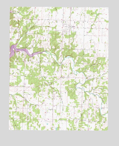
Dadeville, MO USGS Topographic Map
Click on map above to begin viewing in our Map Viewer.

This topographic map contains these locations and features:
Feature Name Type Latitude Longitude GNIS ID View Map
Buchanan CemeteryCemeteryN37.4095°W93.6902°714942View Map
Bunker BranchStreamN37.4339°W93.6571°715045View Map
Bunker HillSummitN37.4378°W93.6438°715048View Map
Burney BranchStreamN37.4139°W93.6491°715081View Map
CaseyvilleLocaleN37.4289°W93.6849°746310View Map
Cave SpringSpringN37.4235°W93.7014°715535View Map
Cave Spring BranchStreamN37.4528°W93.7141°715541View Map
CometPopulated PlaceN37.3973°W93.6324°729863View Map
CorryPopulated PlaceN37.4875°W93.7252°740768View Map
Corry BranchStreamN37.4589°W93.7452°716331View Map
DadevillePopulated PlaceN37.4803°W93.6738°729868View Map
Dadeville Elementary SchoolSchoolN37.4818°W93.6758°2710681View Map
Dadeville Fire DepartmentBuildingN37.4800°W93.6737°2620985View Map
Dadeville Post OfficePost OfficeN37.4804°W93.6736°2782774View Map
Dadeville Senior High SchoolSchoolN37.4817°W93.6745°2710680View Map
Dorall LakeReservoirN37.3765°W93.6904°763035View Map
Fairview ChurchChurchN37.4287°W93.6844°717778View Map
Giddings Lake DamDamN37.3784°W93.6902°763034View Map
Hampton ChurchChurchN37.3962°W93.7002°719051View Map
Hampton School (historical)SchoolN37.3967°W93.7033°746289View Map
Hargrave BranchStreamN37.4256°W93.6535°719093View Map
HulstonPopulated PlaceN37.4545°W93.7327°739495View Map
Hulston MillLocaleN37.4545°W93.7319°740899View Map
Logan CemeteryCemeteryN37.4828°W93.6819°721418View Map
Lumley BranchStreamN37.4148°W93.6552°721672View Map
Masonic CemeteryCemeteryN37.4750°W93.6683°721957View Map
New Hope ChurchChurchN37.4584°W93.7294°723248View Map
Pemberton CemeteryCemeteryN37.4456°W93.7280°724184View Map
Pleasant Hill ChurchChurchN37.3853°W93.6591°724528View Map
Pleasant Hill School (historical)SchoolN37.3914°W93.6505°746290View Map
Rice CemeteryCemeteryN37.4673°W93.6474°725244View Map
Stockton School (historical)SchoolN37.4262°W93.7447°746288View Map
Township of PolkCivilN37.4160°W93.6928°766558View Map
Township of South MorganCivilN37.4865°W93.6740°766563View Map
Village of DadevilleCivilN37.4793°W93.6740°2398667View Map
Ward (historical)BuildingN37.3981°W93.6863°745822View Map
West Prong Lynn BranchStreamN37.4103°W93.7472°728618View Map
Wheeler CemeteryCemeteryN37.4300°W93.6508°728687View Map

Note: Coordinates in the location and feature list above are referenced to NAD83 datum.


Copyright (C) 2008-2024 Ryan Niemi / Sunset Dynamics ... All Rights Reserved