TopoQuest Logo
Do you find TopoQuest useful?
Help keep TopoQuest running and adding new maps/features by donating!
Bitcoin:  19c7KJd3qBynnjoSw5npx9KScwjBe4ifkT
Litecoin:  LXs6TkuXGGXo1vDsWCkWVdjQX94eUKd6ui
Home View Maps Find Maps Find Places Resources & Links


Crumpler, West Virginia Topographic Map

USGS Map Title: Crumpler, WV
USGS Map MRC: 37081D3
DRG (GeoTIFF) Download: o37081d3.tif


Neighboring USGS Topographic Map Quads:


  Mullens, WV  
37081E4
 

  Rhodell, WV  
37081E3
 

  Odd, WV  
37081E2
 

  Keystone, WV  
37081D4
 

  Crumpler, WV  
37081D3
 

  Matoaka, WV  
37081D2
 

  Anawalt, WV  
37081C4
 

  Bramwell, WV  
37081C3
 

  Bluefield, WV  
37081C2


Map MRC Location:

N38°
W82°
N38°
W81°
H8 H7 H6 H5 H4 H3 H2 H1
G8 G7 G6 G5 G4 G3 G2 G1
F8 F7 F6 F5 F4 F3 F2 F1
E8 E7 E6 E5 E4 E3 E2 E1
D8 D7 D6 D5 D4 D3 D2 D1
C8 C7 C6 C5 C4 C3 C2 C1
B8 B7 B6 B5 B4 B3 B2 B1
A8 A7 A6 A5 A4 A3 A2 A1
N37°
W82°
N37°
W81°

Crumpler, WV USGS 1:24K Topographic Map Preview:
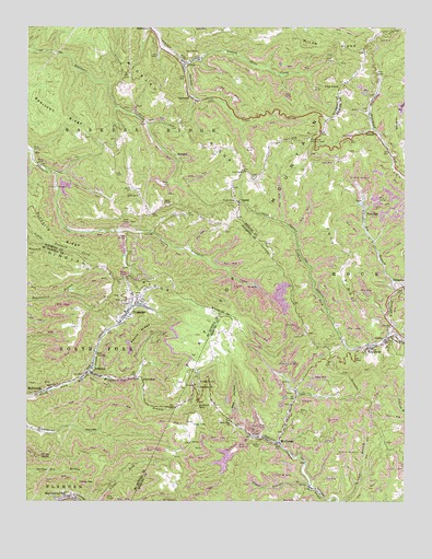
Crumpler, WV USGS Topographic Map
Click on map above to begin viewing in our Map Viewer.

This topographic map contains these locations and features:
Feature Name Type Latitude Longitude GNIS ID View Map
Algonquin (historical)Populated PlaceN37.4523°W81.2995°1557112View Map
Angle HollowValleyN37.3751°W81.3648°1534958View Map
AristaPopulated PlaceN37.4726°W81.2607°1553743View Map
AshlandPopulated PlaceN37.4084°W81.3526°1553758View Map
Ashland Post OfficePost OfficeN37.4090°W81.3537°1689208View Map
Bailey CemeteryCemeteryN37.4579°W81.3404°1535119View Map
Bailey ChapelChurchN37.4534°W81.3279°1535128View Map
Beartown ChurchChurchN37.4562°W81.3379°1535420View Map
Beartown Fork DamDamN37.4584°W81.3332°1559365View Map
Beartown RidgeRidgeN37.4776°W81.3643°1535422View Map
Big BranchStreamN37.4334°W81.2540°1535779View Map
BlackPopulated PlaceN37.4940°W81.2637°1741530View Map
Boyds Branch Refuse DamDamN37.4301°W81.2615°1559083View Map
CherokeePopulated PlaceN37.4071°W81.3368°1554117View Map
Clark GapGapN37.4543°W81.3054°1537356View Map
Clark Gap ChurchChurchN37.4623°W81.3032°1537357View Map
CovelPopulated PlaceN37.4909°W81.3226°1554207View Map
Covel Census Designated PlaceCensusN37.4907°W81.3197°2586787View Map
Covel Missionary Baptist ChurchChurchN37.4909°W81.3209°1741536View Map
Covel Post OfficePost OfficeN37.4909°W81.3219°1741537View Map
Crane Creek ChurchChurchN37.3962°W81.3082°1537792View Map
CrumplerPopulated PlaceN37.4248°W81.3418°1554233View Map
Crumpler Census Designated PlaceCensusN37.4262°W81.3313°2586791View Map
Crumpler Impoundment Number TwoReservoirN37.4410°W81.3428°1559346View Map
Crumpler Post OfficePost OfficeN37.4284°W81.3368°1689228View Map
Dwight Shrewsbury SpringSpringN37.4682°W81.3129°1678183View Map
East Fork of Crane Creek DamDamN37.4084°W81.2898°1559085View Map
Fork RidgeRidgeN37.4412°W81.2687°1539135View Map
GarwoodPopulated PlaceN37.4821°W81.3212°1554535View Map
GiattoPopulated PlaceN37.4176°W81.2559°1554550View Map
Giatto School (historical)SchoolN37.4157°W81.2612°1557202View Map
Gooney Otter Creek DamDamN37.4918°W81.2732°1559364View Map
Harry S Thomas SpringSpringN37.4701°W81.2876°1557640View Map
Johns KnobSummitN37.3871°W81.3659°1554817View Map
LamarPopulated PlaceN37.4540°W81.3048°1554904View Map
Lefthand Fork DamDamN37.4518°W81.2815°1559084View Map
Lefthand Fork Widemouth CreekStreamN37.4193°W81.2548°1541769View Map
Lowe (historical)Populated PlaceN37.4154°W81.2679°1557252View Map
McComasPopulated PlaceN37.3901°W81.2915°1542947View Map
McComas High School (historical)SchoolN37.4007°W81.2876°1557259View Map
McComas Post OfficePost OfficeN37.3904°W81.2909°1559539View Map
MicajahPopulated PlaceN37.4665°W81.3259°1555110View Map
Payne Branch DamDamN37.4418°W81.3415°1559345View Map
Peach RidgeRidgeN37.4196°W81.3373°1544672View Map
Peters GapGapN37.4154°W81.2895°1557302View Map
PiedmontPopulated PlaceN37.4507°W81.2637°1555340View Map
Pilot KnobSummitN37.4846°W81.2718°1555350View Map
Pilot Knob Lookout TowerTowerN37.4707°W81.2818°1557881View Map
Pinnacle RidgeRidgeN37.4490°W81.3709°1544941View Map
Prosperity CemeteryCemeteryN37.4065°W81.3176°1545290View Map
Prosperity School (historical)SchoolN37.4051°W81.3182°1545294View Map
Red HollowValleyN37.3965°W81.3068°1545452View Map
Righthand Fork Widemouth CreekStreamN37.4193°W81.2548°1545745View Map
SmokelessPopulated PlaceN37.4326°W81.2512°1555651View Map
Taylor School (historical)SchoolN37.3751°W81.3007°1547938View Map
Tolliver BranchStreamN37.3921°W81.3004°1548114View Map
Tolliver Branch DamDamN37.3884°W81.3082°1559069View Map
Tolliver Branch LakeReservoirN37.3861°W81.3095°1559070View Map
Turkey GapGapN37.3804°W81.3576°1548345View Map
Upper Georges BranchStreamN37.3793°W81.2809°1548521View Map
WeyanokePopulated PlaceN37.4154°W81.2609°1555962View Map
Widemouth (historical)Populated PlaceN37.4557°W81.2643°1557361View Map
Windmill GapGapN37.4009°W81.3182°1549240View Map
Windmill Gap BranchStreamN37.4096°W81.3543°1549241View Map

Note: Coordinates in the location and feature list above are referenced to NAD83 datum.


Copyright (C) 2008-2024 Ryan Niemi / Sunset Dynamics ... All Rights Reserved