TopoQuest Logo
Do you find TopoQuest useful?
Help keep TopoQuest running and adding new maps/features by donating!
Bitcoin:  19c7KJd3qBynnjoSw5npx9KScwjBe4ifkT
Litecoin:  LXs6TkuXGGXo1vDsWCkWVdjQX94eUKd6ui
Home View Maps Find Maps Find Places Resources & Links


Rhodell, West Virginia Topographic Map

USGS Map Title: Rhodell, WV
USGS Map MRC: 37081E3
DRG (GeoTIFF) Download: o37081e3.tif


Neighboring USGS Topographic Map Quads:


  McGraws, WV  
37081F4
 

  Lester, WV  
37081F3
 

  Crab Orchard, WV  
37081F2
 

  Mullens, WV  
37081E4
 

  Rhodell, WV  
37081E3
 

  Odd, WV  
37081E2
 

  Keystone, WV  
37081D4
 

  Crumpler, WV  
37081D3
 

  Matoaka, WV  
37081D2


Map MRC Location:

N38°
W82°
N38°
W81°
H8 H7 H6 H5 H4 H3 H2 H1
G8 G7 G6 G5 G4 G3 G2 G1
F8 F7 F6 F5 F4 F3 F2 F1
E8 E7 E6 E5 E4 E3 E2 E1
D8 D7 D6 D5 D4 D3 D2 D1
C8 C7 C6 C5 C4 C3 C2 C1
B8 B7 B6 B5 B4 B3 B2 B1
A8 A7 A6 A5 A4 A3 A2 A1
N37°
W82°
N37°
W81°

Rhodell, WV USGS 1:24K Topographic Map Preview:
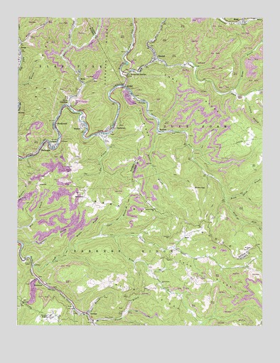
Rhodell, WV USGS Topographic Map
Click on map above to begin viewing in our Map Viewer.

This topographic map contains these locations and features:
Feature Name Type Latitude Longitude GNIS ID View Map
Allen CreekStreamN37.5896°W81.3493°1534884View Map
Allen JunctionPopulated PlaceN37.5893°W81.3507°1553709View Map
Allen Junction Church of GodChurchN37.5934°W81.3470°1741524View Map
Allen Junction Post OfficePost OfficeN37.5885°W81.3520°1741525View Map
AmigoPopulated PlaceN37.5965°W81.3209°1534921View Map
Barkers RidgeRidgeN37.5407°W81.2823°1535240View Map
Barkers Ridge ChurchChurchN37.5473°W81.3054°1535241View Map
BasinPopulated PlaceN37.5368°W81.2895°1535300View Map
Basin Post OfficePost OfficeN37.5312°W81.2943°1741528View Map
BeechwoodPopulated PlaceN37.5818°W81.3559°1553840View Map
Beetree BranchStreamN37.5793°W81.3034°1535579View Map
Big BranchStreamN37.5782°W81.3326°1535782View Map
BlackeaglePopulated PlaceN37.5729°W81.3626°1553916View Map
Bluff ForkStreamN37.5526°W81.2693°1536151View Map
Bragg BranchStreamN37.5951°W81.2668°1536294View Map
Brushy GapGapN37.5562°W81.2848°1536514View Map
Comer BranchStreamN37.5365°W81.3332°1537544View Map
CorinnePopulated PlaceN37.5729°W81.3565°1537686View Map
Corinne Census Designated PlaceCensusN37.5710°W81.3614°2586785View Map
Corinne Post OfficePost OfficeN37.5740°W81.3615°1741535View Map
Devils ForkStreamN37.5976°W81.3215°1538161View Map
Gooney Otter CreekStreamN37.5240°W81.3670°1539515View Map
Guyandotte ChurchChurchN37.5090°W81.3732°1539807View Map
HerndonPopulated PlaceN37.5054°W81.3404°1554688View Map
Herndon Consolidated Elementary and Middle SchoolSchoolN37.5259°W81.3714°1741541View Map
Herndon HeightsPopulated PlaceN37.5034°W81.3587°1554689View Map
Herndon High School (historical)SchoolN37.5021°W81.3340°1741543View Map
Hickory BranchStreamN37.5509°W81.3748°1540203View Map
IroquoisPopulated PlaceN37.5812°W81.3407°1554782View Map
Ivy RidgeRidgeN37.5837°W81.3118°1540756View Map
Jims BranchStreamN37.5046°W81.3387°1540904View Map
Lambert BranchStreamN37.5329°W81.3720°1541323View Map
Left Fork Allen CreekStreamN37.6137°W81.3479°1541619View Map
Lefthand Fork Tommy CreekStreamN37.5959°W81.2532°1541767View Map
London Mills SpringSpringN37.5184°W81.3018°1678180View Map
MadelinePopulated PlaceN37.5804°W81.3043°1542676View Map
MeadPopulated PlaceN37.6246°W81.2607°1543037View Map
Middle Branch Barkers CreekStreamN37.5315°W81.3490°1543158View Map
Mike Ferrell FieldAirportN37.5592°W81.3500°1558788View Map
Milam CemeteryCemeteryN37.5629°W81.3479°1543251View Map
Milam ForkStreamN37.5362°W81.3259°1543258View Map
Milam RidgeRidgeN37.5071°W81.2976°1543259View Map
MontecarloPopulated PlaceN37.5162°W81.3618°1555152View Map
Mount Pisgah ChurchChurchN37.5309°W81.2570°1543734View Map
Narrows Police DepartmentBuildingN37.5506°W81.3561°2086276View Map
Noseman BranchStreamN37.5015°W81.3362°1544243View Map
Otsego Bible ChapelChurchN37.6115°W81.3743°1741569View Map
Peak RidgeRidgeN37.5182°W81.2726°1544677View Map
RhodellPopulated PlaceN37.6087°W81.3057°1545524View Map
Rhodell Police DepartmentBuildingN37.6082°W81.3050°2728161View Map
Rhodell Post OfficePost OfficeN37.6082°W81.3053°1742925View Map
Rhodell Volunteer Fire DepartmentBuildingN37.6079°W81.3053°2577754View Map
Right Fork Cedar CreekStreamN37.6146°W81.3737°1545623View Map
Roy M Lilly Memorial BridgeBridgeN37.5734°W81.3591°2647166View Map
Sand GapGapN37.5523°W81.3409°1546357View Map
Spruce Grove ChurchChurchN37.5176°W81.3012°1547249View Map
StephensonPopulated PlaceN37.5804°W81.3262°1555708View Map
Stephenson Post OfficePost OfficeN37.5792°W81.3307°1741577View Map
Stonecoal CreekStreamN37.6023°W81.3229°1547472View Map
Stonecoal JunctionPopulated PlaceN37.6032°W81.3134°1555717View Map
Tommy CreekStreamN37.6023°W81.3226°1548128View Map
Tommy RidgeRidgeN37.5834°W81.2629°1548129View Map
Town of RhodellCivilN37.6095°W81.3051°2391385View Map
Turkey BranchStreamN37.5937°W81.2590°1548326View Map
Union ChurchChurchN37.5271°W81.2987°1548476View Map
Wiley Spring BranchStreamN37.5526°W81.2693°1549149View Map
Winding GulfStreamN37.5976°W81.3215°1549238View Map
WycoPopulated PlaceN37.5990°W81.3429°1556030View Map
Wyco DamDamN37.6084°W81.3382°1559363View Map
Wyco Post OfficePost OfficeN37.6027°W81.3432°1741581View Map

Note: Coordinates in the location and feature list above are referenced to NAD83 datum.


Copyright (C) 2008-2024 Ryan Niemi / Sunset Dynamics ... All Rights Reserved