TopoQuest Logo
Do you find TopoQuest useful?
Help keep TopoQuest running and adding new maps/features by donating!
Bitcoin:  19c7KJd3qBynnjoSw5npx9KScwjBe4ifkT
Litecoin:  LXs6TkuXGGXo1vDsWCkWVdjQX94eUKd6ui
Home View Maps Find Maps Find Places Resources & Links


Keystone, West Virginia Topographic Map

USGS Map Title: Keystone, WV
USGS Map MRC: 37081D4
DRG (GeoTIFF) Download: o37081d4.tif


Neighboring USGS Topographic Map Quads:


  Pineville, WV  
37081E5
 

  Mullens, WV  
37081E4
 

  Rhodell, WV  
37081E3
 

  Welch, WV  
37081D5
 

  Keystone, WV  
37081D4
 

  Crumpler, WV  
37081D3
 

  Gary, WV  
37081C5
 

  Anawalt, WV  
37081C4
 

  Bramwell, WV  
37081C3


Map MRC Location:

N38°
W82°
N38°
W81°
H8 H7 H6 H5 H4 H3 H2 H1
G8 G7 G6 G5 G4 G3 G2 G1
F8 F7 F6 F5 F4 F3 F2 F1
E8 E7 E6 E5 E4 E3 E2 E1
D8 D7 D6 D5 D4 D3 D2 D1
C8 C7 C6 C5 C4 C3 C2 C1
B8 B7 B6 B5 B4 B3 B2 B1
A8 A7 A6 A5 A4 A3 A2 A1
N37°
W82°
N37°
W81°

Keystone, WV USGS 1:24K Topographic Map Preview:
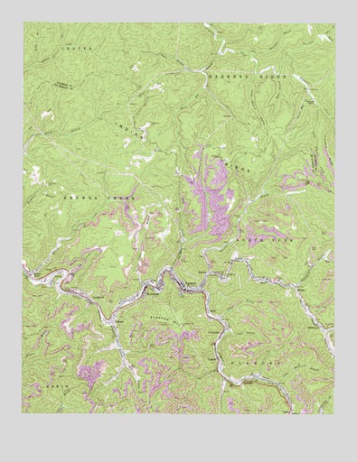
Keystone, WV USGS Topographic Map
Click on map above to begin viewing in our Map Viewer.

This topographic map contains these locations and features:
Feature Name Type Latitude Longitude GNIS ID View Map
AlgomaPopulated PlaceN37.4190°W81.4259°1534873View Map
Algoma CemeteryCemeteryN37.4384°W81.4126°1534874View Map
Algoma Coal ImpoundmentReservoirN37.4334°W81.4115°1558981View Map
Beartown ForkStreamN37.4893°W81.3943°1535421View Map
Bearwallow BranchStreamN37.4154°W81.3907°1535428View Map
Big BranchStreamN37.4198°W81.4823°1535778View Map
Bluefield Police DepartmentBuildingN37.4233°W81.4525°2085886View Map
Bnai Israel SynagogueChurchN37.4118°W81.4534°1689217View Map
Bone BranchStreamN37.4837°W81.3976°1536209View Map
Bottom CreekPopulated PlaceN37.4201°W81.4954°1553954View Map
Bottom CreekStreamN37.4190°W81.4979°1536248View Map
Burk CreekStreamN37.4215°W81.4407°1536741View Map
Buzzard BranchStreamN37.4198°W81.4251°1536809View Map
Buzzard Branch DamDamN37.4334°W81.4115°1558980View Map
City of KeystoneCivilN37.4158°W81.4462°2390606View Map
Clark (historical)Populated PlaceN37.4146°W81.4323°1689227View Map
Clark BranchStreamN37.4159°W81.4512°1537349View Map
Coalbank BranchStreamN37.4043°W81.4657°1537473View Map
Dons BranchStreamN37.3907°W81.4587°1538268View Map
EckmanPopulated PlaceN37.4046°W81.4643°1554363View Map
Eckman Overhead BridgeBridgeN37.4082°W81.4623°2647255View Map
ElkhornPopulated PlaceN37.3857°W81.4109°1554386View Map
EnnisPopulated PlaceN37.3759°W81.3929°1554404View Map
GilliamPopulated PlaceN37.4240°W81.4151°1554553View Map
Grace Episcopal ChurchChurchN37.4032°W81.4643°1689243View Map
Greenbrier HollowValleyN37.4015°W81.3782°1539707View Map
Johns Knob BranchStreamN37.3848°W81.3976°1540964View Map
KeystonePopulated PlaceN37.4148°W81.4509°1554871View Map
Keystone Baptist ChurchChurchN37.4154°W81.4470°1689249View Map
Keystone Baptist ChurchChurchN37.4148°W81.4437°1689250View Map
Keystone Elementary School (historical)SchoolN37.4129°W81.4512°1689251View Map
Keystone Methodist Episcopal ChurchChurchN37.4134°W81.4512°1689252View Map
Keystone Police DepartmentBuildingN37.4150°W81.4509°2728042View Map
Keystone Post OfficePost OfficeN37.4154°W81.4509°1689253View Map
Keystone Refuse Dump Mine Number 1 DamDamN37.4218°W81.4532°1558982View Map
Keystone Refuse ImpoundmentReservoirN37.4218°W81.4532°1558983View Map
Keystone Town HallBuildingN37.4159°W81.4476°1689254View Map
Keystone Volunteer Fire DepartmentBuildingN37.4148°W81.4511°2577542View Map
Keystone-Eckman Negro High School (historical)SchoolN37.4104°W81.4609°1689255View Map
Kimball ChurchChurchN37.4204°W81.4879°1541196View Map
Kimball Elementary SchoolSchoolN37.4203°W81.4974°1689152View Map
Kimball Post OfficePost OfficeN37.4219°W81.4987°1689153View Map
KylePopulated PlaceN37.4082°W81.4257°1554898View Map
Kyle Post OfficePost OfficeN37.4068°W81.4257°1689256View Map
LandgraffPopulated PlaceN37.4118°W81.4737°1554907View Map
Leftwich BranchStreamN37.4018°W81.3782°1689258View Map
Lick BranchStreamN37.4237°W81.4098°1689260View Map
Lick BranchStreamN37.4026°W81.4184°1541827View Map
Little Buzzard BranchStreamN37.4837°W81.4065°1542048View Map
Little Pinnacle CreekStreamN37.4734°W81.3815°1542188View Map
Little Rock ChurchChurchN37.4196°W81.4201°1542197View Map
Masks ChapelChurchN37.4196°W81.4809°1542845View Map
McDowellPopulated PlaceN37.4029°W81.3804°1555083View Map
Memorial Presbyterian ChurchChurchN37.4165°W81.4448°1689268View Map
Midway Shiloh TempleChurchN37.4171°W81.4445°1689269View Map
Mitchem CemeteryCemeteryN37.4571°W81.4209°1543472View Map
Mount Ebenezer ChurchChurchN37.4193°W81.4187°1543639View Map
North Fork Elkhorn CreekStreamN37.4148°W81.4304°1544207View Map
NorthforkPopulated PlaceN37.4209°W81.4401°1544237View Map
Northfork Baptist ChurchChurchN37.4143°W81.4329°1689272View Map
Northfork City HallBuildingN37.4146°W81.4348°1689273View Map
Northfork District High School (historical)SchoolN37.4146°W81.4337°1689274View Map
Northfork Police DepartmentBuildingN37.4154°W81.4351°2728043View Map
Northfork Post OfficePost OfficeN37.4146°W81.4343°1689275View Map
Northfork Presbyterian ChurchChurchN37.4143°W81.4318°1689276View Map
Northfork Public LibraryBuildingN37.4152°W81.4355°2727343View Map
Northfork Volunteer Fire DepartmentBuildingN37.4145°W81.4296°2577563View Map
Payne BranchStreamN37.4848°W81.4287°1544651View Map
PowhatanPopulated PlaceN37.4007°W81.4204°1555402View Map
Powhatan Post OfficePost OfficeN37.4009°W81.4198°1689280View Map
Reedy BranchStreamN37.4871°W81.4940°1545491View Map
Rockhouse CemeteryCemeteryN37.4482°W81.4901°1545977View Map
RolfePopulated PlaceN37.4179°W81.4012°1555518View Map
Rotenberry CemeteryCemeteryN37.4673°W81.4493°1546097View Map
Round Mountain BranchStreamN37.4771°W81.3848°1546111View Map
Rural Retreat Baptist ChurchChurchN37.4978°W81.4603°2085817View Map
Shawnee MountainSummitN37.4034°W81.4354°1555602View Map
Shawnee Mountain Lookout TowerLocaleN37.4037°W81.4354°1689284View Map
Sheridan BranchStreamN37.4898°W81.4076°1546677View Map
Town of NorthforkCivilN37.4196°W81.4274°2391336View Map
Trace BranchStreamN37.4051°W81.4207°1548187View Map
UplandPopulated PlaceN37.3926°W81.4215°1555858View Map
VivianPopulated PlaceN37.4182°W81.4873°1555898View Map
Vivian Census Designated PlaceCensusN37.4172°W81.4922°2586896View Map
White Oak BranchStreamN37.4904°W81.4220°1549033View Map
Wideners Ambulance ServiceBuildingN37.4181°W81.4387°2581152View Map
WorthPopulated PlaceN37.4148°W81.3898°1549423View Map
Worth Post OfficePost OfficeN37.4168°W81.3954°1689302View Map
Zion Pentecostal TabernacleChurchN37.4157°W81.4473°1689304View Map

Note: Coordinates in the location and feature list above are referenced to NAD83 datum.


Copyright (C) 2008-2024 Ryan Niemi / Sunset Dynamics ... All Rights Reserved