TopoQuest Logo
Do you find TopoQuest useful?
Help keep TopoQuest running and adding new maps/features by donating!
Bitcoin:  19c7KJd3qBynnjoSw5npx9KScwjBe4ifkT
Litecoin:  LXs6TkuXGGXo1vDsWCkWVdjQX94eUKd6ui
Home View Maps Find Maps Find Places Resources & Links


Custer, Michigan Topographic Map

USGS Map Title: Custer, MI
USGS Map MRC: 43086H2
DRG (GeoTIFF) Download: o43086h2.tif


Neighboring USGS Topographic Map Quads:


  Free Soil, MI  
44086A2
 

  Millerton, MI  
44086A1


  Custer, MI  
43086H2
 

  Tallman, MI  
43086H1


  Crystal Valley, MI  
43086G2
 

  Carr, MI  
43086G1


Map MRC Location:

N44°
W87°
N44°
W86°
H8 H7 H6 H5 H4 H3 H2 H1
G8 G7 G6 G5 G4 G3 G2 G1
F8 F7 F6 F5 F4 F3 F2 F1
E8 E7 E6 E5 E4 E3 E2 E1
D8 D7 D6 D5 D4 D3 D2 D1
C8 C7 C6 C5 C4 C3 C2 C1
B8 B7 B6 B5 B4 B3 B2 B1
A8 A7 A6 A5 A4 A3 A2 A1
N43°
W87°
N43°
W86°

Custer, MI USGS 1:24K Topographic Map Preview:
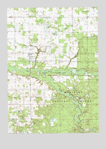
Custer, MI USGS Topographic Map
Click on map above to begin viewing in our Map Viewer.

This topographic map contains these locations and features:
Feature Name Type Latitude Longitude GNIS ID View Map
Allen LakeLakeN43.9807°W86.1951°619979View Map
Bailey LakeLakeN43.9786°W86.1721°1619071View Map
Bartons LakeLakeN43.8884°W86.1880°620669View Map
Big South Branch Pere Marquette RiverStreamN43.9358°W86.2006°1619201View Map
Black CreekStreamN43.9386°W86.2148°1619229View Map
Clancy LakeLakeN43.8763°W86.2269°1619511View Map
Comstock SchoolSchoolN43.9750°W86.1412°623681View Map
CusterPopulated PlaceN43.9520°W86.2195°1619649View Map
Custer Fire DepartmentBuildingN43.9542°W86.2148°2626842View Map
Custer Lookout TowerTowerN43.9142°W86.2323°1623304View Map
Custer Post OfficePost OfficeN43.9544°W86.2203°2514608View Map
Custer StationLocaleN43.9500°W86.2181°2514610View Map
Dockery LakeLakeN43.8971°W86.2372°1619726View Map
Emanuel ChurchChurchN43.9906°W86.1606°625551View Map
Emmanuel Lutheran CemeteryCemeteryN43.9405°W86.1597°2514617View Map
Hatting CreekStreamN43.9556°W86.2065°1622804View Map
Indian TrailTrailN43.8933°W86.1615°1622805View Map
Lakeside CemeteryCemeteryN43.8761°W86.2395°630027View Map
Little River Band of Ottawa Indians ReservationCivilN43.9428°W86.2330°2418998View Map
Mason County Eastern Junior - Senior High SchoolSchoolN43.9539°W86.2178°2514611View Map
McClellan SchoolSchoolN43.9756°W86.1792°1620749View Map
McKimzie LakeLakeN43.9742°W86.1830°631950View Map
Minega SchoolSchoolN43.9772°W86.2406°1620838View Map
Mobey LakeLakeN43.8888°W86.2414°632536View Map
Notipekago Historical MarkerParkN43.9361°W86.2203°2514632View Map
Rathburn LakeSwampN43.8843°W86.2164°635660View Map
Ressigue SchoolSchoolN43.9189°W86.2190°1621374View Map
Riverside CemeteryCemeteryN43.9411°W86.2234°635992View Map
Riverside SchoolSchoolN43.9178°W86.1784°1621399View Map
Saint Mary's ChurchChurchN43.9536°W86.2206°2514609View Map
Saunders LakeLakeN43.9098°W86.1888°637280View Map
Sugar Ridge ChurchChurchN43.9189°W86.2292°1621818View Map
Thorn AirportAirportN43.9303°W86.1640°2650921View Map
Township of CusterCivilN43.9472°W86.2184°1626152View Map
Village of CusterCivilN43.9505°W86.2182°2398663View Map
Weldon CreekStreamN43.9356°W86.1715°1622078View Map
Weldon Creek Post Office (historical)Post OfficeN43.9475°W86.1689°2514255View Map
Weldon Creek StationLocaleN43.9475°W86.1689°2514244View Map
Whelan LakeLakeN43.9099°W86.1544°1616270View Map

Note: Coordinates in the location and feature list above are referenced to NAD83 datum.


Copyright (C) 2008-2025 Ryan Niemi / Sunset Dynamics ... All Rights Reserved