TopoQuest Logo
Do you find TopoQuest useful?
Help keep TopoQuest running and adding new maps/features by donating!
Bitcoin:  19c7KJd3qBynnjoSw5npx9KScwjBe4ifkT
Litecoin:  LXs6TkuXGGXo1vDsWCkWVdjQX94eUKd6ui
Home View Maps Find Maps Find Places Resources & Links


Cutter, Arizona Topographic Map

USGS Map Title: Cutter, AZ
USGS Map MRC: 33110C6
DRG (GeoTIFF) Download: o33110c6.tif


Neighboring USGS Topographic Map Quads:


  Globe, AZ  
33110D7
 

  Cammerman Wash, AZ  
33110D6
 

  Dourine Canyon, AZ  
33110D5
 

  Pinal Peak, AZ  
33110C7
 

  Cutter, AZ  
33110C6
 

  Bucket Mountain, AZ  
33110C5
 

  El Capitan Mountain, AZ  
33110B7
 

  Mescal Warm Spring, AZ  
33110B6
 

  Coolidge Dam, AZ  
33110B5


Map MRC Location:

N34°
W111°
N34°
W110°
H8 H7 H6 H5 H4 H3 H2 H1
G8 G7 G6 G5 G4 G3 G2 G1
F8 F7 F6 F5 F4 F3 F2 F1
E8 E7 E6 E5 E4 E3 E2 E1
D8 D7 D6 D5 D4 D3 D2 D1
C8 C7 C6 C5 C4 C3 C2 C1
B8 B7 B6 B5 B4 B3 B2 B1
A8 A7 A6 A5 A4 A3 A2 A1
N33°
W111°
N33°
W110°

Cutter, AZ USGS 1:24K Topographic Map Preview:
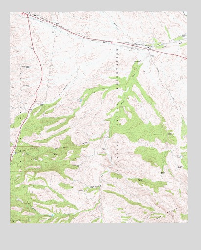
Cutter, AZ USGS Topographic Map
Click on map above to begin viewing in our Map Viewer.

This topographic map contains these locations and features:
Feature Name Type Latitude Longitude GNIS ID View Map
Apache Stronghold Golf ClubLocaleN33.3644°W110.6730°2670358View Map
Apache Stronghold Golf ClubLocaleN33.3639°W110.6728°2670160View Map
Arrastra CanyonValleyN33.2901°W110.7343°25484View Map
Bar F Bar RanchLocaleN33.3206°W110.7287°25960View Map
Branch Creek DamDamN33.2551°W110.7207°39288View Map
Branch Creek TankReservoirN33.2547°W110.7211°26721View Map
Bull CanyonValleyN33.3053°W110.6801°26955View Map
Bull SpringSpringN33.2909°W110.7203°26975View Map
Cactus WellWellN33.2937°W110.6834°27166View Map
Capitan Hayes TankReservoirN33.3423°W110.7369°27278View Map
Copper Hills TankReservoirN33.2842°W110.7021°27923View Map
Coyote Hold DamDamN33.2895°W110.6315°39388View Map
Coyote Hole SpringSpringN33.2830°W110.6331°28118View Map
Coyote Hole TankReservoirN33.2891°W110.6307°28119View Map
CutterPopulated PlaceN33.3528°W110.6526°28221View Map
Cutter Census Designated PlaceCensusN33.3584°W110.6593°2582768View Map
Cutter RanchLocaleN33.3451°W110.6590°28222View Map
Cutter TankReservoirN33.3226°W110.7007°28223View Map
East Globe Census Designated PlaceCensusN33.3512°W110.7053°2582777View Map
Elk SpringSpringN33.2943°W110.7135°28856View Map
Elk Trick TankReservoirN33.2631°W110.7384°28870View Map
Globe City WellWellN33.3631°W110.7198°41302View Map
Grantham WellWellN33.3309°W110.7371°29501View Map
Haunted SpringSpringN33.2755°W110.6576°29791View Map
Hensen TankReservoirN33.2919°W110.7478°29897View Map
Hog MountainSummitN33.2542°W110.6368°30024View Map
Hole in the Rock TankReservoirN33.2713°W110.6947°30061View Map
Indian SpringSpringN33.2948°W110.7315°30356View Map
Martin WellWellN33.3187°W110.6726°31546View Map
Naltazen Dam Number OneDamN33.3001°W110.6757°39649View Map
Nig Well Number TwoWellN33.3326°W110.7062°32322View Map
Ramboz WashStreamN33.3525°W110.6481°33351View Map
Ranch CreekStreamN33.3528°W110.6470°33361View Map
Red Box SpringSpringN33.2796°W110.6445°33429View Map
Rocky SpringSpringN33.3024°W110.6393°33769View Map
San Carlos Apache AirportAirportN33.3548°W110.6685°45363View Map
Spring BranchStreamN33.2623°W110.6876°34722View Map
Twin TanksReservoirN33.3609°W110.6265°35632View Map

Note: Coordinates in the location and feature list above are referenced to NAD83 datum.


Copyright (C) 2008-2025 Ryan Niemi / Sunset Dynamics ... All Rights Reserved