TopoQuest Logo
Do you find TopoQuest useful?
Help keep TopoQuest running and adding new maps/features by donating!
Bitcoin:  19c7KJd3qBynnjoSw5npx9KScwjBe4ifkT
Litecoin:  LXs6TkuXGGXo1vDsWCkWVdjQX94eUKd6ui
Home View Maps Find Maps Find Places Resources & Links


Dale, Oregon Topographic Map

USGS Map Title: Dale, OR
USGS Map MRC: 44118H8
DRG (GeoTIFF) Download: o44118h8.tif


Neighboring USGS Topographic Map Quads:


  Deerhorn Creek, OR  
45119A1
 

  Bridge Creek, OR  
45118A8
 

  Ukiah SE, OR  
45118A7
 

  Meadow Brook Summit, OR  
44119H1
 

  Dale, OR  
44118H8
 

  The Cockscomb, OR  
44118H7
 

  Flowers Gulch, OR  
44119G1
 

  Wildcat Point, OR  
44118G8
 

  Sharp Ridge, OR  
44118G7


Map MRC Location:

N45°
W119°
N45°
W118°
H8 H7 H6 H5 H4 H3 H2 H1
G8 G7 G6 G5 G4 G3 G2 G1
F8 F7 F6 F5 F4 F3 F2 F1
E8 E7 E6 E5 E4 E3 E2 E1
D8 D7 D6 D5 D4 D3 D2 D1
C8 C7 C6 C5 C4 C3 C2 C1
B8 B7 B6 B5 B4 B3 B2 B1
A8 A7 A6 A5 A4 A3 A2 A1
N44°
W119°
N44°
W118°

Dale, OR USGS 1:24K Topographic Map Preview:
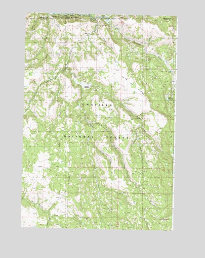
Dale, OR USGS Topographic Map
Click on map above to begin viewing in our Map Viewer.

This topographic map contains these locations and features:
Feature Name Type Latitude Longitude GNIS ID View Map
Board GulchValleyN44.8815°W118.9766°1138352View Map
Brush CreekStreamN44.9363°W118.9453°1138713View Map
Bully CreekStreamN44.9593°W118.9522°1138947View Map
Case PlaceLocaleN44.9629°W118.8927°1638104View Map
Case RidgeRidgeN44.9602°W118.9100°1118650View Map
Case SpringSpringN44.9671°W118.9345°1116595View Map
DalePopulated PlaceN44.9885°W118.9475°1140600View Map
Dale Post OfficePost OfficeN44.9885°W118.9475°1165126View Map
Dale Ranger Station (historical)LocaleN44.9943°W118.9400°1638102View Map
Dale Work CenterLocaleN44.9938°W118.9391°1140602View Map
Deep CanyonValleyN44.9363°W118.9022°1140787View Map
Desolation CreekStreamN44.9974°W118.9364°1140923View Map
Duff MeadowsFlatN44.9515°W118.8825°1141377View Map
East Fork Meadow BrookStreamN44.9688°W118.9661°1141583View Map
George Hinton RanchLocaleN44.8824°W118.9625°1638103View Map
Hinton CreekStreamN44.9985°W118.9811°1143615View Map
Howard MeadowsFlatN44.9590°W118.9511°1143852View Map
Knapp RanchLocaleN44.9104°W118.9819°1638105View Map
Meadow Brooks FallsFallsN44.9633°W118.9584°1116596View Map
Moonshine CreekStreamN44.9674°W118.8789°1146429View Map
RangePopulated PlaceN44.8929°W118.9686°1159217View Map
Range Post Office (historical)Post OfficeN44.8929°W118.9686°1165836View Map
Road Camp SpringSpringN44.8820°W118.8848°1148499View Map
Smith CreekStreamN44.9629°W118.9730°1149749View Map
Snake CreekStreamN44.9915°W118.9428°1152996View Map
Spring CanyonValleyN44.9243°W118.9458°1150155View Map
Toll Bridge Recreation SiteLocaleN44.9963°W118.9353°1156117View Map
Twin SpringSpringN44.9739°W118.9001°1151587View Map
West Fork Meadow BrookStreamN44.9979°W118.9458°1152092View Map

Note: Coordinates in the location and feature list above are referenced to NAD83 datum.


Copyright (C) 2008-2024 Ryan Niemi / Sunset Dynamics ... All Rights Reserved