TopoQuest Logo
Do you find TopoQuest useful?
Help keep TopoQuest running and adding new maps/features by donating!
Bitcoin:  19c7KJd3qBynnjoSw5npx9KScwjBe4ifkT
Litecoin:  LXs6TkuXGGXo1vDsWCkWVdjQX94eUKd6ui
Home View Maps Find Maps Find Places Resources & Links


Dalzell, South Carolina Topographic Map

USGS Map Title: Dalzell, SC
USGS Map MRC: 34080A4
DRG (GeoTIFF) Download: o34080a4.tif


Neighboring USGS Topographic Map Quads:


  Camden South, SC  
34080B5
 

  Spring Hill, SC  
34080B4
 

  Bishopville West, SC  
34080B3
 

  Rembert, SC  
34080A5
 

  Dalzell, SC  
34080A4
 

  Oswego, SC  
34080A3
 

  Wedgefield, SC  
33080H5
 

  Sumter West, SC  
33080H4
 

  Sumter East, SC  
33080H3


Map MRC Location:

N35°
W81°
N35°
W80°
H8 H7 H6 H5 H4 H3 H2 H1
G8 G7 G6 G5 G4 G3 G2 G1
F8 F7 F6 F5 F4 F3 F2 F1
E8 E7 E6 E5 E4 E3 E2 E1
D8 D7 D6 D5 D4 D3 D2 D1
C8 C7 C6 C5 C4 C3 C2 C1
B8 B7 B6 B5 B4 B3 B2 B1
A8 A7 A6 A5 A4 A3 A2 A1
N34°
W81°
N34°
W80°

Dalzell, SC USGS 1:24K Topographic Map Preview:
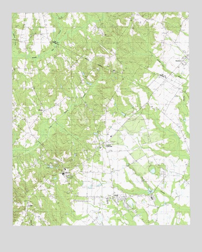
Dalzell, SC USGS Topographic Map
Click on map above to begin viewing in our Map Viewer.

This topographic map contains these locations and features:
Feature Name Type Latitude Longitude GNIS ID View Map
Ardis PondReservoirN34.0202°W80.4331°1239308View Map
Ardis PondLakeN34.0202°W80.4028°1220231View Map
Ardis Pond Dam D-1979DamN34.0202°W80.4331°1239307View Map
Barnett PondReservoirN34.0654°W80.4216°1239302View Map
Barnett Pond Dam D-1976DamN34.0652°W80.4215°1239301View Map
BordenPopulated PlaceN34.0677°W80.4781°1220898View Map
Borden School (historical)SchoolN34.0715°W80.4673°1244464View Map
Bracey Mill CreekStreamN34.0999°W80.4992°1246962View Map
Burrows CrossroadsPopulated PlaceN34.0854°W80.3917°1244477View Map
CatchallPopulated PlaceN34.0096°W80.4904°1247189View Map
DalzellPopulated PlaceN34.0168°W80.4301°1221916View Map
Dalzell Census Designated PlaceCensusN34.0189°W80.4299°2402399View Map
Dalzell Post OfficePost OfficeN34.0160°W80.4326°1244604View Map
Dalzell SchoolSchoolN34.0002°W80.4395°1247479View Map
Ebenezer SchoolSchoolN34.0163°W80.4031°1247631View Map
Elizabeth CemeteryCemeteryN34.0710°W80.4684°1222261View Map
Elizabeth Church (historical)ChurchN34.0718°W80.4670°1244511View Map
Evenezer ChurchChurchN34.0177°W80.4020°1244510View Map
Gaillard CrossroadsPopulated PlaceN34.0493°W80.4345°1247856View Map
Grant Hill ChurchChurchN34.0721°W80.4481°1245811View Map
HillcrestPopulated PlaceN34.0352°W80.4645°1223183View Map
Hillcrest SchoolSchoolN34.0307°W80.4640°1244562View Map
Hopewell ChurchChurchN34.0157°W80.4892°1246040View Map
Horeb ChurchChurchN34.0327°W80.4512°1246061View Map
Lake View PondReservoirN34.0347°W80.4727°1239304View Map
Lake View Pond Dam D-1977DamN34.0335°W80.4731°1239303View Map
Mount Carmel CemeteryCemeteryN34.0415°W80.4395°1224695View Map
Mount Joshua ChurchChurchN34.0688°W80.4342°1224722View Map
Mount Joshua School (historical)SchoolN34.0613°W80.4345°1244610View Map
Mount Olive ChurchChurchN34.0993°W80.3779°1249622View Map
Nebo School (historical)SchoolN34.0746°W80.4040°1224939View Map
New Hope ChurchChurchN34.0921°W80.4992°1249820View Map
Norsworthy PondReservoirN34.0935°W80.4381°1239298View Map
Norsworthy Pond Dam D-1975DamN34.0935°W80.4381°1239297View Map
Pecan AcresPopulated PlaceN34.0146°W80.4517°1244637View Map
Providence ChurchChurchN34.0304°W80.4604°1250263View Map
Providence School (historical)SchoolN34.0265°W80.4726°1244653View Map
Rembert Memorial School (historical)SchoolN34.0654°W80.4970°1225840View Map
Rock Shed School (historical)SchoolN34.0693°W80.4992°1244661View Map
Ross PondReservoirN34.0359°W80.4187°1239306View Map
Ross Pond Dam D-1978DamN34.0368°W80.4198°1239305View Map
Saint James Church (historical)ChurchN34.0521°W80.4156°1244667View Map
Saint James School (historical)SchoolN34.0518°W80.4154°1244672View Map
Saint James School (historical)SchoolN34.1021°W80.4662°1244673View Map
Saint Phillips ChurchChurchN34.1049°W80.4256°1226265View Map
Saint Phillips Church (historical)ChurchN34.0352°W80.3767°1250700View Map
Sumter County Rural Fire Department DalzellBuildingN34.0127°W80.4384°2578404View Map
Sumter North DivisionCivilN34.0288°W80.3970°1938435View Map
Thomas Sumter AcademySchoolN34.0335°W80.4629°1244743View Map
Tirzah Presbyterian ChurchChurchN34.0027°W80.4434°1244748View Map
WoodrowPopulated PlaceN34.0949°W80.3779°1251503View Map

Note: Coordinates in the location and feature list above are referenced to NAD83 datum.


Copyright (C) 2008-2024 Ryan Niemi / Sunset Dynamics ... All Rights Reserved