TopoQuest Logo
Do you find TopoQuest useful?
Help keep TopoQuest running and adding new maps/features by donating!
Bitcoin:  19c7KJd3qBynnjoSw5npx9KScwjBe4ifkT
Litecoin:  LXs6TkuXGGXo1vDsWCkWVdjQX94eUKd6ui
Home View Maps Find Maps Find Places Resources & Links


Spring Hill, South Carolina Topographic Map

USGS Map Title: Spring Hill, SC
USGS Map MRC: 34080B4
DRG (GeoTIFF) Download: o34080b4.tif


Neighboring USGS Topographic Map Quads:


  Camden North, SC  
34080C5
 

  Cassatt, SC  
34080C4
 

  Lucknow, SC  
34080C3
 

  Camden South, SC  
34080B5
 

  Spring Hill, SC  
34080B4
 

  Bishopville West, SC  
34080B3
 

  Rembert, SC  
34080A5
 

  Dalzell, SC  
34080A4
 

  Oswego, SC  
34080A3


Map MRC Location:

N35°
W81°
N35°
W80°
H8 H7 H6 H5 H4 H3 H2 H1
G8 G7 G6 G5 G4 G3 G2 G1
F8 F7 F6 F5 F4 F3 F2 F1
E8 E7 E6 E5 E4 E3 E2 E1
D8 D7 D6 D5 D4 D3 D2 D1
C8 C7 C6 C5 C4 C3 C2 C1
B8 B7 B6 B5 B4 B3 B2 B1
A8 A7 A6 A5 A4 A3 A2 A1
N34°
W81°
N34°
W80°

Spring Hill, SC USGS 1:24K Topographic Map Preview:
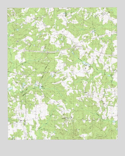
Spring Hill, SC USGS Topographic Map
Click on map above to begin viewing in our Map Viewer.

This topographic map contains these locations and features:
Feature Name Type Latitude Longitude GNIS ID View Map
AntiochPopulated PlaceN34.2399°W80.4687°1231006View Map
Antioch Baptist ChurchChurchN34.2399°W80.4604°1235332View Map
Antioch Elementary SchoolSchoolN34.2354°W80.4784°1235333View Map
Ashwood DivisionCivilN34.1420°W80.3793°1938188View Map
Central High School (historical)SchoolN34.1635°W80.4181°1236905View Map
Community Bible ChurchChurchN34.1821°W80.4392°1221702View Map
Corbitts MillpondReservoirN34.1855°W80.3843°1247383View Map
Corbitts Millpond Dam D-1721DamN34.1860°W80.3867°1239495View Map
Elizabeth ChurchChurchN34.2193°W80.4120°1247654View Map
Gospel Hill Church (historical)ChurchN34.1799°W80.4862°1245790View Map
Interchange 108CrossingN34.2135°W80.4217°1228164View Map
Ionia School (historical)SchoolN34.2035°W80.3984°1236923View Map
Kershaw County Fire Station AntiochBuildingN34.2366°W80.4781°2578260View Map
Lee County Rural Fire Department Red HillBuildingN34.1907°W80.4066°2578580View Map
McCaskill CemeteryCemeteryN34.2343°W80.4020°1224388View Map
McLeod School (historical)SchoolN34.1843°W80.4787°1235372View Map
McLeods Lower PondReservoirN34.1968°W80.4065°1238264View Map
McLeods PondLakeN34.1963°W80.4076°1224424View Map
McLeods Upper PondReservoirN34.1963°W80.4084°1239492View Map
McLeods Upper Pond Dam D-2409DamN34.1985°W80.4098°1239491View Map
Mizpah ChurchChurchN34.2054°W80.4079°1246701View Map
Mount Calvary ChurchChurchN34.1532°W80.4245°1249550View Map
Newell PondReservoirN34.1435°W80.3765°1238262View Map
Oak Grove School (historical)SchoolN34.1765°W80.4337°1236946View Map
Pine Grove ChurchChurchN34.1310°W80.4773°1250105View Map
PisgahPopulated PlaceN34.1429°W80.4856°1250139View Map
Pisgah ChurchChurchN34.1424°W80.4851°1244645View Map
Red HillPopulated PlaceN34.1690°W80.4112°1225783View Map
Red Hill Baptist ChurchChurchN34.1671°W80.4067°1236948View Map
Reedy Branch School (historical)SchoolN34.2452°W80.4029°1236949View Map
Rock Hill ChurchChurchN34.1532°W80.4395°1250422View Map
Rock Hill School (historical)SchoolN34.1777°W80.3820°1236950View Map
Saint Andrews ChurchChurchN34.1621°W80.3929°1250496View Map
Saint James ChurchChurchN34.1727°W80.4309°1226124View Map
Saint Johns ChurchChurchN34.1449°W80.4340°1250550View Map
Saint Johns ChurchChurchN34.1846°W80.4787°1226158View Map
Saint Lukes ChurchChurchN34.1843°W80.4767°1235384View Map
Saint Phillips ChurchChurchN34.2388°W80.4167°1250701View Map
Saint Phillips School (historical)SchoolN34.2399°W80.4123°1236960View Map
Saints ChurchChurchN34.1913°W80.3781°1250713View Map
Salem ChurchChurchN34.1946°W80.3829°1226287View Map
Sand Hill CemeteryCemeteryN34.1285°W80.4512°1226325View Map
Sandy Hill Plantation (historical)LocaleN34.1863°W80.4906°1235385View Map
Shiver MillpondLakeN34.1750°W80.4626°1226588View Map
South Carolina Noname 28038 D-2536 DamDamN34.2302°W80.4898°1238222View Map
South Carolina Noname 31016 D-2406 DamDamN34.1422°W80.3774°1238261View Map
South Carolina Noname 31018 D-2408 DamDamN34.1963°W80.4076°1238263View Map
Spring HillPopulated PlaceN34.1515°W80.4384°1251001View Map
Spring HillSummitN34.1452°W80.4320°1706229View Map
Spring Hill School (historical)SchoolN34.1515°W80.4381°1236969View Map
West Lee SchoolSchoolN34.1632°W80.4201°1251389View Map
Windi Knoll LakeReservoirN34.2270°W80.4022°1239498View Map
Windi Knoll Lake D-1723 DamDamN34.2268°W80.4031°1239497View Map
WQHB-TV (Sumter)TowerN34.1482°W80.4701°1252589View Map
Zion Hill Church (historical)ChurchN34.2199°W80.4554°1227764View Map

Note: Coordinates in the location and feature list above are referenced to NAD83 datum.


Copyright (C) 2008-2024 Ryan Niemi / Sunset Dynamics ... All Rights Reserved