TopoQuest Logo
Do you find TopoQuest useful?
Help keep TopoQuest running and adding new maps/features by donating!
Bitcoin:  19c7KJd3qBynnjoSw5npx9KScwjBe4ifkT
Litecoin:  LXs6TkuXGGXo1vDsWCkWVdjQX94eUKd6ui
Home View Maps Find Maps Find Places Resources & Links


Rembert, South Carolina Topographic Map

USGS Map Title: Rembert, SC
USGS Map MRC: 34080A5
DRG (GeoTIFF) Download: o34080a5.tif


Neighboring USGS Topographic Map Quads:


  Lugoff, SC  
34080B6
 

  Camden South, SC  
34080B5
 

  Spring Hill, SC  
34080B4
 

  Leesburg, SC  
34080A6
 

  Rembert, SC  
34080A5
 

  Dalzell, SC  
34080A4
 

  Eastover, SC  
33080H6
 

  Wedgefield, SC  
33080H5
 

  Sumter West, SC  
33080H4


Map MRC Location:

N35°
W81°
N35°
W80°
H8 H7 H6 H5 H4 H3 H2 H1
G8 G7 G6 G5 G4 G3 G2 G1
F8 F7 F6 F5 F4 F3 F2 F1
E8 E7 E6 E5 E4 E3 E2 E1
D8 D7 D6 D5 D4 D3 D2 D1
C8 C7 C6 C5 C4 C3 C2 C1
B8 B7 B6 B5 B4 B3 B2 B1
A8 A7 A6 A5 A4 A3 A2 A1
N34°
W81°
N34°
W80°

Rembert, SC USGS 1:24K Topographic Map Preview:
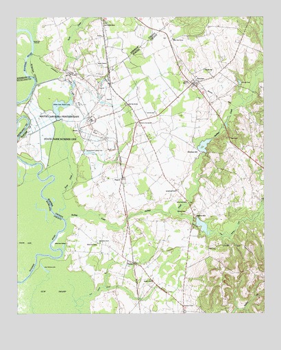
Rembert, SC USGS Topographic Map
Click on map above to begin viewing in our Map Viewer.

This topographic map contains these locations and features:
Feature Name Type Latitude Longitude GNIS ID View Map
Ancrum FerryLocaleN34.1149°W80.6165°1244877View Map
Bethesda ChurchChurchN34.0427°W80.5398°1220588View Map
BoykinPopulated PlaceN34.1168°W80.5815°1246960View Map
Boykin Census Designated PlaceCensusN34.1198°W80.5886°2629819View Map
Buckingham Landing PondReservoirN34.0682°W80.5888°1221084View Map
Church of the AscensionChurchN34.0807°W80.5626°1247294View Map
Dinkins MillPopulated PlaceN34.0407°W80.5345°1231228View Map
Dinkins MillpondReservoirN34.0370°W80.5311°1251610View Map
Dinkins Millpond Dam D-1461DamN34.0385°W80.5331°1239300View Map
Duck Bottom LakeLakeN34.0193°W80.6109°1222126View Map
Ellerbee (historical)Populated PlaceN34.1096°W80.5470°1244513View Map
Ellerbees MillPopulated PlaceN34.0679°W80.5317°1247657View Map
Ellerbees MillpondReservoirN34.0708°W80.5302°1251609View Map
Ellerbees Millpond Dam D-1460DamN34.0685°W80.5315°1239299View Map
Godgold SubdivisionPopulated PlaceN34.1038°W80.5354°1244538View Map
Good Hope ChurchChurchN34.0882°W80.5684°1222750View Map
Good Hope School (historical)SchoolN34.0882°W80.5687°1244543View Map
HagoodPopulated PlaceN34.0571°W80.5718°1245876View Map
Happy Home SubdivisionPopulated PlaceN34.0504°W80.5259°1244552View Map
Harvins PondReservoirN34.0918°W80.5698°1239294View Map
Harvins Pond Dam D-1973DamN34.0918°W80.5698°1239293View Map
Henry School (historical)SchoolN34.0865°W80.5251°1244558View Map
HoratioPopulated PlaceN34.0213°W80.5659°1223295View Map
Little Rafting CreekStreamN34.0435°W80.5431°1224027View Map
Live Oak SchoolSchoolN34.0852°W80.5545°1224084View Map
McCrearys Quarter (historical)Populated PlaceN34.0635°W80.6220°1249218View Map
McDuffie PondReservoirN34.0935°W80.5131°1239296View Map
McDuffie Pond Dam D-1974DamN34.0935°W80.5131°1239295View Map
McLeod ChapelChurchN34.1029°W80.5295°1246606View Map
McLeods PondReservoirN34.0975°W80.5119°1224425View Map
Mount Bethel ChurchChurchN34.1163°W80.5456°1249541View Map
Pisgah ChurchChurchN34.0743°W80.5167°1250143View Map
Rafting CreekStreamN34.0399°W80.6004°1225737View Map
Rafting Creek ChurchChurchN34.0477°W80.5392°1250284View Map
Rafting Creek SchoolSchoolN34.0518°W80.5440°1250285View Map
RembertPopulated PlaceN34.0957°W80.5334°1231717View Map
Rembert Census Designated PlaceCensusN34.1037°W80.5305°2403470View Map
Rembert DivisionCivilN34.0860°W80.5348°1938397View Map
Remberts Methodist ChurchChurchN34.0954°W80.5359°1244657View Map
Saint Stephens ChurchChurchN34.1218°W80.5809°1250706View Map
Sanders CornerPopulated PlaceN34.0029°W80.5406°1231768View Map
South Carolina Penitentiary State Farm Number OneLocaleN34.0779°W80.6131°1246725View Map
State Farm (historical)Populated PlaceN34.0968°W80.5773°1244707View Map
Sumter Fire Department Horatio Station 11BuildingN34.0246°W80.5728°2578327View Map
Sumter Fire Department Rembert Station 8BuildingN34.0971°W80.5346°2578535View Map
Sumters LandingLocaleN34.0379°W80.5998°1244733View Map
Swift CreekStreamN34.0415°W80.6031°1251094View Map
Trinity Church (historical)ChurchN34.0410°W80.5693°1244751View Map
Wannah PlantationLocaleN34.1049°W80.5815°1227392View Map
Wateree River Correctional InstitutionBuildingN34.0818°W80.5867°2735642View Map
Westberry School (historical)SchoolN34.0146°W80.5576°1251394View Map
White Oak Slash LakeReservoirN34.0886°W80.6014°1227552View Map
White Oak Slash Lake Dam D-1972DamN34.0818°W80.6031°1239291View Map
Willow Grove CemeteryCemeteryN34.0296°W80.5998°1227626View Map
Willow Grove ChurchChurchN34.0299°W80.5829°1251459View Map
Willow Grove SchoolSchoolN34.0296°W80.5840°1227627View Map

Note: Coordinates in the location and feature list above are referenced to NAD83 datum.


Copyright (C) 2008-2024 Ryan Niemi / Sunset Dynamics ... All Rights Reserved