TopoQuest Logo
Do you find TopoQuest useful?
Help keep TopoQuest running and adding new maps/features by donating!
Bitcoin:  19c7KJd3qBynnjoSw5npx9KScwjBe4ifkT
Litecoin:  LXs6TkuXGGXo1vDsWCkWVdjQX94eUKd6ui
Home View Maps Find Maps Find Places Resources & Links


Danielsville, Alabama Topographic Map

USGS Map Title: Danielsville, AL
USGS Map MRC: 31086H4
DRG (GeoTIFF) Download: o31086h4.tif


Neighboring USGS Topographic Map Quads:


  Calhoun, AL  
32086A5
 

  Sandy Ridge, AL  
32086A4
 

  Sellers, AL  
32086A3
 

  Fort Deposit, AL  
31086H5
 

  Danielsville, AL  
31086H4
 

  Lapine, AL  
31086H3
 

  Greenville East, AL  
31086G5
 

  Honoraville, AL  
31086G4
 

  Fullers Crossroads, AL  
31086G3


Map MRC Location:

N32°
W87°
N32°
W86°
H8 H7 H6 H5 H4 H3 H2 H1
G8 G7 G6 G5 G4 G3 G2 G1
F8 F7 F6 F5 F4 F3 F2 F1
E8 E7 E6 E5 E4 E3 E2 E1
D8 D7 D6 D5 D4 D3 D2 D1
C8 C7 C6 C5 C4 C3 C2 C1
B8 B7 B6 B5 B4 B3 B2 B1
A8 A7 A6 A5 A4 A3 A2 A1
N31°
W87°
N31°
W86°

Danielsville, AL USGS 1:24K Topographic Map Preview:
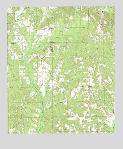
Danielsville, AL USGS Topographic Map
Click on map above to begin viewing in our Map Viewer.

This topographic map contains these locations and features:
Feature Name Type Latitude Longitude GNIS ID View Map
Antioch ChurchChurchN31.9651°W86.4502°113135View Map
Beaver BranchStreamN31.8760°W86.3775°113710View Map
Bethel CemeteryCemeteryN31.9507°W86.4669°135752View Map
Bethel Methodist ChurchChurchN31.9507°W86.4661°114048View Map
Browns LakeReservoirN31.9982°W86.4199°115015View Map
Cool Springs ChurchChurchN31.9488°W86.4005°116545View Map
DaisyPopulated PlaceN31.8990°W86.4847°156246View Map
Daisy School (historical)SchoolN31.8982°W86.4844°135000View Map
DanielsvillePopulated PlaceN31.9207°W86.4064°117057View Map
Danielsville ChurchChurchN31.9207°W86.4077°133914View Map
Danielsville School (historical)SchoolN31.9202°W86.4061°133915View Map
Dry CemeteryCemeteryN31.8926°W86.3975°117525View Map
Ellis CrossroadsPopulated PlaceN31.9782°W86.4514°156308View Map
Ellis PondReservoirN31.9785°W86.4534°117950View Map
Flatwood ChurchChurchN31.9790°W86.4305°136350View Map
FlatwoodsPopulated PlaceN31.9788°W86.4308°118406View Map
Hopewell CemeteryCemeteryN31.8779°W86.4336°120359View Map
King CemeteryCemeteryN31.9265°W86.4569°121210View Map
Lime Spring BranchStreamN31.8838°W86.4614°164072View Map
LoganPopulated PlaceN31.9860°W86.4905°121962View Map
Maple BranchStreamN31.9021°W86.4419°122264View Map
McGough PondReservoirN31.9053°W86.4347°122552View Map
Mitchell DamDamN31.8852°W86.4933°130005View Map
Moseley Mill CreekStreamN31.8929°W86.4572°123105View Map
New Oaky Bower ChurchChurchN31.9204°W86.4836°152664View Map
Oak Bowery CemeteryCemeteryN31.9210°W86.4950°164176View Map
Oak Bowery Primitive Baptist ChurchChurchN31.9207°W86.4947°152757View Map
Oak Grove CemeteryCemeteryN31.8763°W86.4397°124065View Map
PanolaPopulated PlaceN31.9715°W86.3889°124399View Map
Panola CemeteryCemeteryN31.9635°W86.3958°154629View Map
Panola ChurchChurchN31.9715°W86.3889°133957View Map
Perdue CemeteryCemeteryN31.8826°W86.4839°124607View Map
Providence Church of ChristChurchN31.8907°W86.4847°152671View Map
Rabbit BranchStreamN31.9240°W86.4414°125392View Map
Ryals LakeReservoirN31.9964°W86.4699°126062View Map
Salem ChurchChurchN31.9046°W86.3783°126239View Map
Spring CreekStreamN31.9090°W86.4586°127222View Map
Spring Creek CemeteryCemeteryN31.9201°W86.4497°135792View Map
Spring Creek Missionary Baptist ChurchChurchN31.9199°W86.4500°153528View Map
Spring Creek Volunteer Fire DepartmentBuildingN31.9435°W86.4603°2691339View Map
Steiners Store (historical)LocaleN31.9071°W86.4783°154091View Map
Stringer Mill CreekStreamN31.9163°W86.4541°153591View Map
Thompson PondReservoirN31.8863°W86.4926°153686View Map
Union ChurchChurchN31.8838°W86.4897°128288View Map

Note: Coordinates in the location and feature list above are referenced to NAD83 datum.


Copyright (C) 2008-2025 Ryan Niemi / Sunset Dynamics ... All Rights Reserved