TopoQuest Logo
Do you find TopoQuest useful?
Help keep TopoQuest running and adding new maps/features by donating!
Bitcoin:  19c7KJd3qBynnjoSw5npx9KScwjBe4ifkT
Litecoin:  LXs6TkuXGGXo1vDsWCkWVdjQX94eUKd6ui
Home View Maps Find Maps Find Places Resources & Links


Lapine, Alabama Topographic Map

USGS Map Title: Lapine, AL
USGS Map MRC: 31086H3
DRG (GeoTIFF) Download: o31086h3.tif


Neighboring USGS Topographic Map Quads:


  Sandy Ridge, AL  
32086A4
 

  Sellers, AL  
32086A3
 

  Ramer, AL  
32086A2
 

  Danielsville, AL  
31086H4
 

  Lapine, AL  
31086H3
 

  Grady, AL  
31086H2
 

  Honoraville, AL  
31086G4
 

  Fullers Crossroads, AL  
31086G3
 

  Petrey, AL  
31086G2


Map MRC Location:

N32°
W87°
N32°
W86°
H8 H7 H6 H5 H4 H3 H2 H1
G8 G7 G6 G5 G4 G3 G2 G1
F8 F7 F6 F5 F4 F3 F2 F1
E8 E7 E6 E5 E4 E3 E2 E1
D8 D7 D6 D5 D4 D3 D2 D1
C8 C7 C6 C5 C4 C3 C2 C1
B8 B7 B6 B5 B4 B3 B2 B1
A8 A7 A6 A5 A4 A3 A2 A1
N31°
W87°
N31°
W86°

Lapine, AL USGS 1:24K Topographic Map Preview:
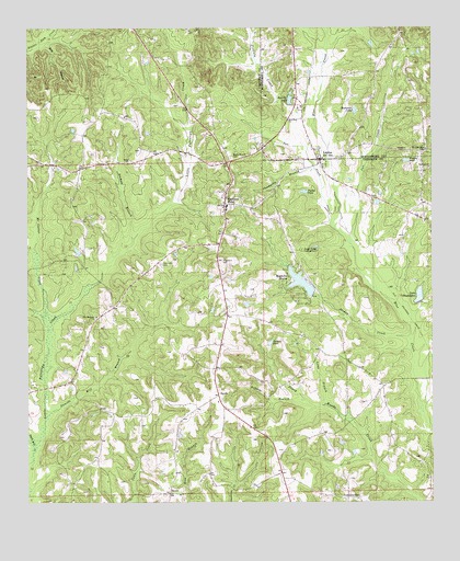
Lapine, AL USGS Topographic Map
Click on map above to begin viewing in our Map Viewer.

This topographic map contains these locations and features:
Feature Name Type Latitude Longitude GNIS ID View Map
Berea ChurchChurchN31.9643°W86.3436°113942View Map
Berkley Mill CreekStreamN31.9504°W86.3722°113948View Map
Bethel Church (historical)ChurchN31.8932°W86.2794°133900View Map
Bradleton Lake DamDamN31.9285°W86.2533°130022View Map
Cat CreekStreamN31.9432°W86.2747°115691View Map
Cauthens CemeteryCemeteryN31.9379°W86.3336°155013View Map
Champion BranchStreamN31.9627°W86.2861°115926View Map
Champion LakeReservoirN31.9782°W86.2744°115930View Map
Clay Jordan StadiumParkN31.9531°W86.3114°2363592View Map
Daniels Mill (historical)LocaleN31.9218°W86.3333°133913View Map
Daniels Mill BranchStreamN31.8979°W86.3689°117056View Map
GarnersvillePopulated PlaceN31.8763°W86.2727°118843View Map
Highland HomePopulated PlaceN31.9535°W86.3139°155099View Map
Highland Home ChurchChurchN31.9538°W86.3083°154628View Map
Highland Home Church of ChristChurchN31.9518°W86.3144°143062View Map
Highland Home High SchoolSchoolN31.9529°W86.3133°133928View Map
Highland Home Post OfficePost OfficeN31.9443°W86.3156°168362View Map
Highland Home Volunteer Fire and RescueBuildingN31.9220°W86.3134°2691098View Map
Jackson PondReservoirN31.9165°W86.3002°120782View Map
Jordan CreekStreamN31.9182°W86.2572°151926View Map
Lake BradleytonReservoirN31.9295°W86.2540°114816View Map
LapinePopulated PlaceN31.9657°W86.2844°151995View Map
LaPine ChurchChurchN31.9660°W86.2850°142662View Map
Lapine Post OfficePost OfficeN31.9655°W86.2851°169043View Map
Lapine School (historical)SchoolN31.9793°W86.2902°142663View Map
Long BranchStreamN31.9004°W86.2827°121986View Map
Mac Carter CreekStreamN31.9207°W86.3686°122135View Map
Magnolia ShoresPopulated PlaceN31.9327°W86.2941°122217View Map
Magnolia Shores Lake DamDamN31.9302°W86.2866°130024View Map
McCants School (historical)SchoolN31.9876°W86.2669°142689View Map
Morgan PondReservoirN31.9651°W86.2579°123048View Map
Mountain Home School (historical)SchoolN31.9696°W86.3680°133949View Map
New Bethel ChurchChurchN31.9618°W86.2939°154627View Map
New Ebenezer ChurchChurchN31.9240°W86.3536°152617View Map
New Hope ChurchChurchN31.9757°W86.2941°123810View Map
Nichols BranchStreamN31.9443°W86.3422°123936View Map
Paynes PondReservoirN31.9569°W86.2894°124514View Map
Petrey-Highland Home DivisionCivilN31.9179°W86.3097°165727View Map
Philadelphia CemeteryCemeteryN31.9676°W86.2511°124675View Map
Roberts BranchStreamN31.9021°W86.2894°125695View Map
Rock BranchStreamN31.9943°W86.3747°125743View Map
Rockdale ChurchChurchN31.9635°W86.2508°125786View Map
Rocky Mount CemeteryCemeteryN31.9657°W86.3116°125863View Map
Russells LakeReservoirN31.9811°W86.2937°126045View Map
Ryals Mill CreekStreamN31.8879°W86.3730°126063View Map
SardisPopulated PlaceN31.9029°W86.3158°126397View Map
Sardis CemeteryCemeteryN31.9015°W86.3152°143064View Map
Sardis Church of ChristChurchN31.9015°W86.3164°143063View Map
SavillePopulated PlaceN31.8774°W86.3311°157020View Map
Saville ChurchChurchN31.8771°W86.3283°133972View Map
Spring Hill ChurchChurchN31.8771°W86.2805°155342View Map
Sugar Ridge CampgroundLocaleN31.9415°W86.2900°127507View Map
Sugar Ridge ChurchChurchN31.9504°W86.3016°133977View Map
T W Spear Memorial AirportAirportN31.9711°W86.2953°2676337View Map
Tan CreekStreamN31.9471°W86.2800°127658View Map

Note: Coordinates in the location and feature list above are referenced to NAD83 datum.


Copyright (C) 2008-2024 Ryan Niemi / Sunset Dynamics ... All Rights Reserved