TopoQuest Logo
Do you find TopoQuest useful?
Help keep TopoQuest running and adding new maps/features by donating!
Bitcoin:  19c7KJd3qBynnjoSw5npx9KScwjBe4ifkT
Litecoin:  LXs6TkuXGGXo1vDsWCkWVdjQX94eUKd6ui
Home View Maps Find Maps Find Places Resources & Links


Sandy Ridge, Alabama Topographic Map

USGS Map Title: Sandy Ridge, AL
USGS Map MRC: 32086A4
DRG (GeoTIFF) Download: o32086a4.tif


Neighboring USGS Topographic Map Quads:


  Hayneville, AL  
32086B5
 

  Letohatchee, AL  
32086B4
 

  Snowdoun, AL  
32086B3
 

  Calhoun, AL  
32086A5
 

  Sandy Ridge, AL  
32086A4
 

  Sellers, AL  
32086A3
 

  Fort Deposit, AL  
31086H5
 

  Danielsville, AL  
31086H4
 

  Lapine, AL  
31086H3


Map MRC Location:

N33°
W87°
N33°
W86°
H8 H7 H6 H5 H4 H3 H2 H1
G8 G7 G6 G5 G4 G3 G2 G1
F8 F7 F6 F5 F4 F3 F2 F1
E8 E7 E6 E5 E4 E3 E2 E1
D8 D7 D6 D5 D4 D3 D2 D1
C8 C7 C6 C5 C4 C3 C2 C1
B8 B7 B6 B5 B4 B3 B2 B1
A8 A7 A6 A5 A4 A3 A2 A1
N32°
W87°
N32°
W86°

Sandy Ridge, AL USGS 1:24K Topographic Map Preview:
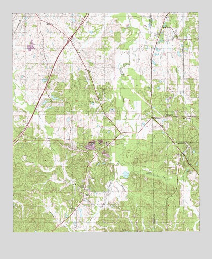
Sandy Ridge, AL USGS Topographic Map
Click on map above to begin viewing in our Map Viewer.

This topographic map contains these locations and features:
Feature Name Type Latitude Longitude GNIS ID View Map
Armstrong CemeteryCemeteryN32.0346°W86.3797°113221View Map
Beautiful Zion African Methodist Episcopal Zion ChurchChurchN32.0129°W86.4580°136478View Map
Beaver Dam CreekStreamN32.0418°W86.4269°113740View Map
Big Zion ChurchChurchN32.1126°W86.4008°147715View Map
Big Zion SchoolSchoolN32.1126°W86.4005°114337View Map
Browns DamDamN32.0001°W86.4200°130052View Map
Burgony CreekStreamN32.0001°W86.3794°115227View Map
Calvary ChurchChurchN32.0385°W86.3825°133905View Map
Cedar LakeReservoirN32.0867°W86.4787°136332View Map
ClearviewPopulated PlaceN32.0432°W86.3880°163147View Map
DavenportPopulated PlaceN32.0657°W86.4064°155052View Map
E B and S L Payne LakeReservoirN32.1064°W86.4875°130145View Map
E B and S L Payne Lake DamDamN32.1051°W86.4883°130146View Map
Flatwoods CreekStreamN32.0315°W86.4319°118408View Map
Gaston LakeReservoirN32.0771°W86.4729°136358View Map
Gaston Lake TwoReservoirN32.0742°W86.4785°130110View Map
Gus Gaston Dam OneDamN32.0785°W86.4733°130114View Map
Gus Gaston Dam TwoDamN32.0735°W86.4800°130111View Map
Guys PondReservoirN32.1140°W86.4472°136365View Map
Guys Village ChurchChurchN32.0646°W86.3839°150908View Map
Guys Village SchoolSchoolN32.0649°W86.3852°119526View Map
Hazley SchoolSchoolN32.0746°W86.4650°119908View Map
Hickory Grove CemeteryCemeteryN32.0668°W86.3969°120023View Map
Interchange 151CrossingN32.1099°W86.4614°155655View Map
Lamar CemeteryCemeteryN32.0907°W86.4839°121349View Map
Lily Missionary Baptist ChurchChurchN32.1190°W86.4766°136383View Map
Lily SchoolSchoolN32.1190°W86.4766°121630View Map
Maddox DamDamN32.0635°W86.4000°130099View Map
Maddox LakeReservoirN32.0634°W86.3984°130100View Map
Magnolia CemeteryCemeteryN32.0451°W86.3847°1730340View Map
Magnolia ChurchChurchN32.0457°W86.3847°122212View Map
McQueens PondReservoirN32.0388°W86.4419°136395View Map
Means LakeReservoirN32.0643°W86.4625°136397View Map
Mount Nebo ChurchChurchN32.0090°W86.4566°123268View Map
Payne CemeteryCemeteryN32.0213°W86.4516°124510View Map
Paynes DamDamN32.0868°W86.4800°130117View Map
Pierces HillSummitN32.0401°W86.4491°136425View Map
Pintlala Volunteer Fire Department Station 2BuildingN32.0876°W86.3813°2691396View Map
Robinsons PondReservoirN32.0488°W86.4534°136441View Map
Sandy RidgePopulated PlaceN32.0246°W86.4519°155234View Map
Sandy Ridge ChurchChurchN32.0226°W86.4525°136452View Map
Sandy Ridge SchoolSchoolN32.0126°W86.4577°126385View Map
Sandy Ridge Volunteer Fire DepartmentBuildingN32.0302°W86.4508°2691596View Map
Sawyer CemeteryCemeteryN32.0304°W86.4477°126448View Map
W D Farrior Junior LakeReservoirN32.1209°W86.4589°130171View Map
W D Farrior Junior Lake DamDamN32.1218°W86.4566°130172View Map
W E Pritchett Lake Dam Number OneDamN32.0085°W86.4550°130054View Map
W E Pritchett Lake Dam Number TwoDamN32.0118°W86.4550°130057View Map
W E Pritchett Lake Number OneReservoirN32.0101°W86.4544°130053View Map
W E Pritchett Lake Number TwoReservoirN32.0101°W86.4544°130056View Map
White Cloud ChurchChurchN32.0913°W86.4486°128869View Map
White Cloud Church (historical)ChurchN32.1040°W86.4791°136472View Map
ZionPopulated PlaceN32.1126°W86.4027°142964View Map

Note: Coordinates in the location and feature list above are referenced to NAD83 datum.


Copyright (C) 2008-2025 Ryan Niemi / Sunset Dynamics ... All Rights Reserved