TopoQuest Logo
Do you find TopoQuest useful?
Help keep TopoQuest running and adding new maps/features by donating!
Bitcoin:  19c7KJd3qBynnjoSw5npx9KScwjBe4ifkT
Litecoin:  LXs6TkuXGGXo1vDsWCkWVdjQX94eUKd6ui
Home View Maps Find Maps Find Places Resources & Links


Sellers, Alabama Topographic Map

USGS Map Title: Sellers, AL
USGS Map MRC: 32086A3
DRG (GeoTIFF) Download: o32086a3.tif


Neighboring USGS Topographic Map Quads:


  Letohatchee, AL  
32086B4
 

  Snowdoun, AL  
32086B3
 

  Davis Crossroads, AL  
32086B2
 

  Sandy Ridge, AL  
32086A4
 

  Sellers, AL  
32086A3
 

  Ramer, AL  
32086A2
 

  Danielsville, AL  
31086H4
 

  Lapine, AL  
31086H3
 

  Grady, AL  
31086H2


Map MRC Location:

N33°
W87°
N33°
W86°
H8 H7 H6 H5 H4 H3 H2 H1
G8 G7 G6 G5 G4 G3 G2 G1
F8 F7 F6 F5 F4 F3 F2 F1
E8 E7 E6 E5 E4 E3 E2 E1
D8 D7 D6 D5 D4 D3 D2 D1
C8 C7 C6 C5 C4 C3 C2 C1
B8 B7 B6 B5 B4 B3 B2 B1
A8 A7 A6 A5 A4 A3 A2 A1
N32°
W87°
N32°
W86°

Sellers, AL USGS 1:24K Topographic Map Preview:
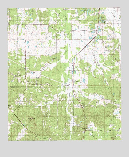
Sellers, AL USGS Topographic Map
Click on map above to begin viewing in our Map Viewer.

This topographic map contains these locations and features:
Feature Name Type Latitude Longitude GNIS ID View Map
AdaPopulated PlaceN32.1054°W86.2764°112911View Map
Bedsole BranchStreamN32.0601°W86.3083°154630View Map
Bedsole DamDamN32.0918°W86.3533°130123View Map
Bedsole LakeReservoirN32.0925°W86.3531°130122View Map
Bell CemeteryCemeteryN32.1035°W86.2772°113854View Map
BethlehemPopulated PlaceN32.0535°W86.3436°114107View Map
Bethlehem ChurchChurchN32.0546°W86.3433°147711View Map
Browns PondsReservoirN32.1190°W86.2865°115020View Map
Cauthen Lake Number OneReservoirN32.1018°W86.2683°130137View Map
Cauthen Lake Number TwoReservoirN32.0966°W86.2834°130132View Map
Cauthen Number 1 DamDamN32.1018°W86.2683°130136View Map
Cauthen Number 2 DamDamN32.0968°W86.2833°130131View Map
Cauthen PondReservoirN32.1021°W86.2806°115712View Map
Charles Davis DamDamN32.0901°W86.2766°130119View Map
Collins DamDamN32.1185°W86.2683°130163View Map
Davenport Gap Filler Annex (historical)MilitaryN32.0039°W86.3292°2088762View Map
Duncan LakeReservoirN32.1224°W86.2924°117664View Map
Fair Prospect CemeteryCemeteryN32.0113°W86.2891°118108View Map
FletaPopulated PlaceN32.1096°W86.3522°118417View Map
Friendship ChurchChurchN32.1013°W86.3208°118678View Map
Guys CrossroadsLocaleN32.0640°W86.3575°142584View Map
Hill DamDamN32.0918°W86.2766°130121View Map
Lake Ta-laleReservoirN32.1149°W86.2725°127617View Map
Leisure LakeReservoirN32.1122°W86.2700°121495View Map
Little Zion ChurchChurchN32.0857°W86.2625°129334View Map
Mead DamDamN32.1151°W86.2716°130156View Map
Mize DamDamN32.0568°W86.2900°130095View Map
Montgomery Hunting Club LakeReservoirN32.0940°W86.2764°130120View Map
Mose ChapelChurchN32.0776°W86.3258°152386View Map
Mount CarmelPopulated PlaceN32.0610°W86.3652°123160View Map
Mount CarmelSummitN32.0207°W86.3491°123163View Map
Mount Hill ChurchChurchN32.0538°W86.3430°142734View Map
Mount Olive ChurchChurchN32.0326°W86.3744°123329View Map
NaftelPopulated PlaceN32.0096°W86.2891°156765View Map
Norman DamDamN32.0251°W86.2533°130064View Map
Normans LakeReservoirN32.0258°W86.2549°130065View Map
Nutson Number 1 DamDamN32.1168°W86.2900°130162View Map
Nutson Number 2 DamDamN32.1201°W86.2900°130170View Map
Nutson Number 3 DamDamN32.1201°W86.2883°130168View Map
Oakdale ChurchChurchN32.0290°W86.2533°152748View Map
Pine AcresPopulated PlaceN32.0757°W86.2589°142792View Map
Pleasant Hill ChurchChurchN32.0904°W86.2825°124990View Map
Rutland PondReservoirN32.0987°W86.2811°126054View Map
Sardis ChurchChurchN32.0026°W86.2594°126409View Map
SellersPopulated PlaceN32.0563°W86.3030°126534View Map
Sellers LakeReservoirN32.0566°W86.2911°130096View Map
Skinner LakeReservoirN32.1090°W86.2830°126935View Map
Skywood Lake Number OneReservoirN32.1168°W86.2900°130161View Map
Skywood Lake Number ThreeReservoirN32.1201°W86.2883°130167View Map
Skywood Lake Number TwoReservoirN32.1216°W86.2904°130169View Map
StrataPopulated PlaceN32.0346°W86.2941°127454View Map
Strata ChurchChurchN32.0338°W86.2922°142887View Map
Strata Church of ChristChurchN32.0332°W86.2936°143061View Map
Strata School (historical)SchoolN32.0404°W86.2966°142888View Map
Surles ChurchChurchN32.0057°W86.3414°127567View Map
Underwood Number 1 DamDamN32.1035°W86.2700°130141View Map
Underwood Number 2 DamDamN32.1101°W86.2700°130151View Map
Underwood PondReservoirN32.1033°W86.2737°128259View Map
Warrs LakeReservoirN32.1199°W86.2699°128604View Map
Zion Hill SchoolSchoolN32.0832°W86.2683°129354View Map

Note: Coordinates in the location and feature list above are referenced to NAD83 datum.


Copyright (C) 2008-2024 Ryan Niemi / Sunset Dynamics ... All Rights Reserved