TopoQuest Logo
Do you find TopoQuest useful?
Help keep TopoQuest running and adding new maps/features by donating!
Bitcoin:  19c7KJd3qBynnjoSw5npx9KScwjBe4ifkT
Litecoin:  LXs6TkuXGGXo1vDsWCkWVdjQX94eUKd6ui
Home View Maps Find Maps Find Places Resources & Links


Danielsville North, Georgia Topographic Map

USGS Map Title: Danielsville North, GA
USGS Map MRC: 34083B2
DRG (GeoTIFF) Download: o34083b2.tif


Neighboring USGS Topographic Map Quads:


  Ashland, GA  
34083C3
 

  Carnesville, GA  
34083C2
 

  Royston, GA  
34083C1
 

  Ila, GA  
34083B3
 

  Danielsville North, GA  
34083B2
 

  Bowman, GA  
34083B1
 

  Hull, GA  
34083A3
 

  Danielsville South, GA  
34083A2
 

  Carlton, GA  
34083A1


Map MRC Location:

N35°
W84°
N35°
W83°
H8 H7 H6 H5 H4 H3 H2 H1
G8 G7 G6 G5 G4 G3 G2 G1
F8 F7 F6 F5 F4 F3 F2 F1
E8 E7 E6 E5 E4 E3 E2 E1
D8 D7 D6 D5 D4 D3 D2 D1
C8 C7 C6 C5 C4 C3 C2 C1
B8 B7 B6 B5 B4 B3 B2 B1
A8 A7 A6 A5 A4 A3 A2 A1
N34°
W84°
N34°
W83°

Danielsville North, GA USGS 1:24K Topographic Map Preview:
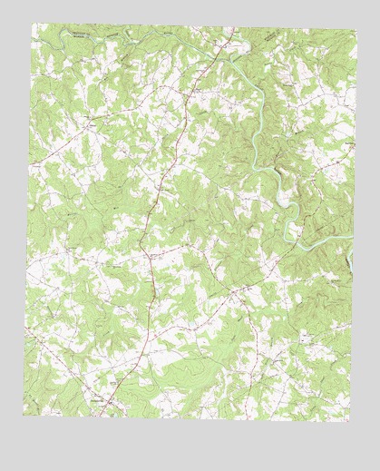
Danielsville North, GA USGS Topographic Map
Click on map above to begin viewing in our Map Viewer.

This topographic map contains these locations and features:
Feature Name Type Latitude Longitude GNIS ID View Map
Adams CemeteryCemeteryN34.1440°W83.2371°335447View Map
Baptist Association LakeReservoirN34.1284°W83.2465°339145View Map
Bethel ChurchChurchN34.1673°W83.1651°354623View Map
BluestonePopulated PlaceN34.1759°W83.2027°335454View Map
Bluestone ChurchChurchN34.1768°W83.2024°354793View Map
Bluestone CreekStreamN34.1829°W83.1515°311566View Map
Bluestone School (historical)SchoolN34.1604°W83.2021°335455View Map
BondPopulated PlaceN34.2298°W83.1874°331208View Map
Bonds Academy (historical)SchoolN34.2251°W83.1899°335456View Map
Bonds FordCrossingN34.2398°W83.1790°335457View Map
Bragg Ferry (historical)CrossingN34.2387°W83.1726°349309View Map
Broad River DivisionCivilN34.2176°W83.1636°1936133View Map
Carruths Mill (historical)LocaleN34.2446°W83.2263°335463View Map
Cedar GrovePopulated PlaceN34.1440°W83.1543°335464View Map
Cedar Grove BranchStreamN34.1587°W83.1499°355059View Map
Cedar Grove ChurchChurchN34.1437°W83.1543°355060View Map
DaltonPopulated PlaceN34.1659°W83.1704°335478View Map
Daniels Ferry (historical)CrossingN34.1821°W83.1465°335479View Map
Danielsville Community Volunteer Fire DepartmentBuildingN34.1256°W83.2222°2603831View Map
Danielsville DivisionCivilN34.1469°W83.1988°1936215View Map
Danielsville Police DepartmentBuildingN34.1256°W83.2213°2734027View Map
Davids Home ChurchChurchN34.1690°W83.1329°355447View Map
Dove BranchStreamN34.1896°W83.2310°335488View Map
Fairfield ChurchChurchN34.1362°W83.2135°355756View Map
Fitz BridgeBridgeN34.2398°W83.1790°335494View Map
Fortson BranchStreamN34.1857°W83.2402°335497View Map
Fowler BranchStreamN34.2057°W83.1563°355900View Map
Fowlers Academy (historical)SchoolN34.2257°W83.1460°335498View Map
Georgia Forestry Commission Madison OfficeBuildingN34.1443°W83.2384°2604504View Map
Gholston LakeReservoirN34.1251°W83.1415°339195View Map
Gholston Lake DamDamN34.1251°W83.1415°339194View Map
Grimes DamDamN34.2301°W83.2132°339188View Map
Grimes LakeReservoirN34.2286°W83.2117°339189View Map
Hanna CreekStreamN34.2321°W83.1646°356157View Map
Hanna Creek ChurchChurchN34.2321°W83.1490°356158View Map
Hill CemeteryCemeteryN34.2084°W83.2388°335502View Map
Hog BranchStreamN34.2437°W83.2102°315498View Map
Hudson RiverStreamN34.2390°W83.1729°328245View Map
James Spring (historical)Populated PlaceN34.2371°W83.2074°335507View Map
Jones ChapelChurchN34.1979°W83.1999°316225View Map
Kingdom HallChurchN34.1382°W83.2271°335511View Map
M M Land Development Company DamDamN34.1351°W83.2415°339142View Map
M M Land Development Company LakeReservoirN34.1351°W83.2415°339143View Map
Macedonia ChurchChurchN34.1734°W83.2165°317568View Map
Madison CountyCivilN34.1278°W83.2090°1688004View Map
Madison County Detention CenterBuildingN34.1464°W83.2354°2734105View Map
Madison County Emergency Medical Services Station 1BuildingN34.1445°W83.2377°2625442View Map
Madison County Sheriff's OfficeBuildingN34.1464°W83.2353°2733855View Map
Madison SpringsPopulated PlaceN34.2098°W83.1746°334696View Map
Mason Mill (historical)LocaleN34.1890°W83.2040°335517View Map
Masons Mill CreekStreamN34.1854°W83.1663°317777View Map
Morgantown Baptist Association DamDamN34.1284°W83.2465°339144View Map
Nails CreekStreamN34.2446°W83.2110°354250View Map
New Haven ChurchChurchN34.1782°W83.2340°319332View Map
New Hope ChurchChurchN34.2362°W83.1832°319436View Map
Norcross School (historical)SchoolN34.2201°W83.2263°335530View Map
Peoples ChurchChurchN34.2204°W83.2263°320372View Map
PhillipsPopulated PlaceN34.2279°W83.1888°335538View Map
Salem ChurchChurchN34.2448°W83.1793°322368View Map
ShilohPopulated PlaceN34.2171°W83.2279°326514View Map
Shiloh Baptist ChurchChurchN34.2173°W83.2277°335549View Map
Shiloh CreekStreamN34.2140°W83.1643°322902View Map
Shiloh Volunteer Fire DepartmentBuildingN34.2167°W83.2281°2604880View Map
TranscoPopulated PlaceN34.1501°W83.1449°335558View Map
Trinity ChurchChurchN34.1537°W83.2029°335559View Map
VelpoePopulated PlaceN34.1768°W83.2340°335560View Map
Velpoe School (historical)SchoolN34.1768°W83.2343°335561View Map
Ward BranchStreamN34.1876°W83.1776°335563View Map
Ware CemeteryCemeteryN34.1465°W83.2004°335564View Map
Wildcat Bridge (historical)BridgeN34.1951°W83.1543°335565View Map

Note: Coordinates in the location and feature list above are referenced to NAD83 datum.


Copyright (C) 2008-2024 Ryan Niemi / Sunset Dynamics ... All Rights Reserved