TopoQuest Logo
Do you find TopoQuest useful?
Help keep TopoQuest running and adding new maps/features by donating!
Bitcoin:  19c7KJd3qBynnjoSw5npx9KScwjBe4ifkT
Litecoin:  LXs6TkuXGGXo1vDsWCkWVdjQX94eUKd6ui
Home View Maps Find Maps Find Places Resources & Links


May Tank Pocket, Arizona Topographic Map

USGS Map Title: May Tank Pocket, AZ
USGS Map MRC: 35112A2
DRG (GeoTIFF) Download: o35112a2.tif


Neighboring USGS Topographic Map Quads:


  McLellan Reservoir, AZ  
35112B3
 

  Williams South, AZ  
35112B2
 

  Davenport Hill, AZ  
35112B1
 

  Matterhorn, AZ  
35112A3
 

  May Tank Pocket, AZ  
35112A2
 

  White Horse Lake, AZ  
35112A1
 

  Hell Point, AZ  
34112H3
 

  Perkinsville, AZ  
34112H2
 

  Sycamore Basin, AZ  
34112H1


Map MRC Location:

N36°
W113°
N36°
W112°
H8 H7 H6 H5 H4 H3 H2 H1
G8 G7 G6 G5 G4 G3 G2 G1
F8 F7 F6 F5 F4 F3 F2 F1
E8 E7 E6 E5 E4 E3 E2 E1
D8 D7 D6 D5 D4 D3 D2 D1
C8 C7 C6 C5 C4 C3 C2 C1
B8 B7 B6 B5 B4 B3 B2 B1
A8 A7 A6 A5 A4 A3 A2 A1
N35°
W113°
N35°
W112°

May Tank Pocket, AZ USGS 1:24K Topographic Map Preview:
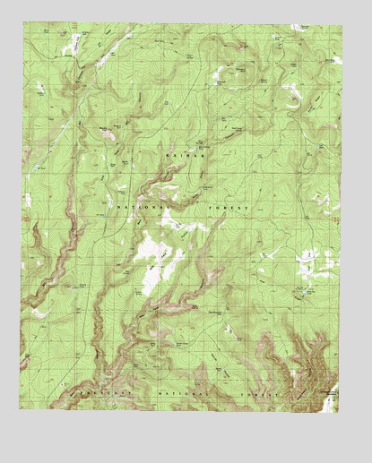
May Tank Pocket, AZ USGS Topographic Map
Click on map above to begin viewing in our Map Viewer.

This topographic map contains these locations and features:
Feature Name Type Latitude Longitude GNIS ID View Map
Baldy TankReservoirN35.0207°W112.1985°40624View Map
Bandit TankReservoirN35.0797°W112.2090°25942View Map
Bear SpringsSpringN35.0869°W112.1801°26119View Map
Bear Springs TankReservoirN35.0852°W112.1822°37635View Map
Ben SpringSpringN35.0446°W112.2079°40627View Map
Breached TankReservoirN35.0478°W112.2277°2062702View Map
Burro TankReservoirN35.1217°W112.2431°40601View Map
Buzzard KnollSummitN35.0903°W112.2177°27103View Map
Buzzard TankReservoirN35.0913°W112.2118°40632View Map
County TankReservoirN35.0397°W112.2277°37728View Map
Davenport KnollSummitN35.1097°W112.1621°28287View Map
Davenport TankReservoirN35.1055°W112.1760°28290View Map
DT TankReservoirN35.0626°W112.2178°28649View Map
East Fork M C CanyonValleyN35.0550°W112.2291°28760View Map
Elk RidgeCliffN35.1006°W112.2293°37774View Map
Frog PoolReservoirN35.0174°W112.2468°29214View Map
Golden Bucksin MineMineN35.0047°W112.2110°37817View Map
Hat TankReservoirN35.0945°W112.1733°40628View Map
Hidden TankReservoirN35.1017°W112.2421°37830View Map
Highway TankReservoirN35.0702°W112.2098°29979View Map
Indian SpringSpringN35.0383°W112.2060°40626View Map
Jackass FlatFlatN35.1189°W112.2310°30466View Map
Jackass TankReservoirN35.1210°W112.2283°37856View Map
Last TankReservoirN35.0864°W112.1518°37893View Map
Little Pine FlatFlatN35.1064°W112.1424°37905View Map
May TankReservoirN35.0622°W112.1713°31601View Map
May Tank CanyonValleyN35.0103°W112.2174°31602View Map
May Tank PocketBasinN35.0475°W112.1991°31603View Map
MC TankReservoirN35.1153°W112.2168°31424View Map
Mud Seep TankReservoirN35.1134°W112.1287°37952View Map
Mud SpringsSpringN35.1149°W112.1868°32132View Map
Mud TankReservoirN35.1189°W112.1958°40635View Map
Nat TanksReservoirN35.0739°W112.2216°37961View Map
Oak TankReservoirN35.0859°W112.1351°32474View Map
Overland Road Historic TrailTrailN35.0858°W112.1916°2062701View Map
Pine FlatFlatN35.0447°W112.1332°32934View Map
Pine Flat HeadquartersLocaleN35.0397°W112.1393°40625View Map
Pine Flat TankReservoirN35.0390°W112.1397°32940View Map
Pine Mountain TankReservoirN35.0318°W112.1719°37988View Map
Pine RidgeRidgeN35.0400°W112.1518°32962View Map
Pot TankReservoirN35.0597°W112.1908°40631View Map
Rock TankReservoirN35.0625°W112.2438°38039View Map
Rocky RidgeCliffN35.0917°W112.1316°38042View Map
Secret PocketFlatN35.0086°W112.1704°34195View Map
Secret TankReservoirN35.0135°W112.1713°34197View Map
Sheep TankReservoirN35.0788°W112.2166°34349View Map
Stewart SpringSpringN35.1070°W112.1581°34849View Map
Summit SpringSpringN35.1240°W112.1420°34948View Map
Summit TankReservoirN35.1202°W112.1528°40634View Map
Susan TankReservoirN35.0233°W112.1661°38095View Map
Thirtysix TankReservoirN35.0780°W112.2452°35256View Map
Trap TankReservoirN35.0993°W112.1933°40629View Map
Turkey TankReservoirN35.1153°W112.1577°40633View Map
Verde SpringSpringN35.0337°W112.1837°38141View Map
Wild Horse CanyonValleyN35.0681°W112.2007°36163View Map
Wild Horse SpringSpringN35.0910°W112.1646°36170View Map
Wild Horse TankReservoirN35.0736°W112.1791°38169View Map
Winter Camp TankReservoirN35.0215°W112.1898°36334View Map
Wyno TankReservoirN35.0138°W112.2061°40623View Map

Note: Coordinates in the location and feature list above are referenced to NAD83 datum.


Copyright (C) 2008-2024 Ryan Niemi / Sunset Dynamics ... All Rights Reserved