TopoQuest Logo
Do you find TopoQuest useful?
Help keep TopoQuest running and adding new maps/features by donating!
Bitcoin:  19c7KJd3qBynnjoSw5npx9KScwjBe4ifkT
Litecoin:  LXs6TkuXGGXo1vDsWCkWVdjQX94eUKd6ui
Home View Maps Find Maps Find Places Resources & Links


Davis City, Iowa Topographic Map

USGS Map Title: Davis City, IA
USGS Map MRC: 40093F7
DRG (GeoTIFF) Download: o40093f7.tif


Neighboring USGS Topographic Map Quads:


  Grand River, IA  
40093G8
 

  Van Wert, IA  
40093G7
 

  Garden Grove SW, IA  
40093G6
 

  Lamoni North, IA  
40093F8
 

  Davis City, IA  
40093F7
 

  Leon, IA  
40093F6
 

  Lamoni South, IA  
40093E8
 

  Akron, MO  
40093E7
 

  Pleasanton, IA  
40093E6


Map MRC Location:

N41°
W94°
N41°
W93°
H8 H7 H6 H5 H4 H3 H2 H1
G8 G7 G6 G5 G4 G3 G2 G1
F8 F7 F6 F5 F4 F3 F2 F1
E8 E7 E6 E5 E4 E3 E2 E1
D8 D7 D6 D5 D4 D3 D2 D1
C8 C7 C6 C5 C4 C3 C2 C1
B8 B7 B6 B5 B4 B3 B2 B1
A8 A7 A6 A5 A4 A3 A2 A1
N40°
W94°
N40°
W93°

Davis City, IA USGS 1:24K Topographic Map Preview:
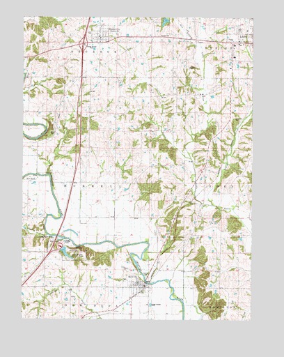
Davis City, IA USGS Topographic Map
Click on map above to begin viewing in our Map Viewer.

This topographic map contains these locations and features:
Feature Name Type Latitude Longitude GNIS ID View Map
Assembly of God ChurchChurchN40.7419°W93.8338°1969715View Map
Assembly of God ChurchChurchN40.6392°W93.8116°1969719View Map
BarrellPopulated PlaceN40.6981°W93.8674°467227View Map
Bethel CemeteryCemeteryN40.6656°W93.7711°1969711View Map
Bethel ChurchChurchN40.6653°W93.7713°1822767View Map
BlocklyPopulated PlaceN40.6597°W93.7549°467228View Map
Blockly (historical)LocaleN40.6597°W93.7549°1969592View Map
Blockly Post Office (historical)Post OfficeN40.6597°W93.7549°1969593View Map
Boswell Brothers ElevatorLocaleN40.6392°W93.8116°1969720View Map
Britton BranchStreamN40.6917°W93.7836°1822768View Map
Burrell Post Office (historical)Post OfficeN40.6875°W93.8669°1969590View Map
Chase Cemetery (historical)CemeteryN40.6333°W93.7752°1969698View Map
Church of ChristChurchN40.6392°W93.8116°1969721View Map
City of Davis CityCivilN40.6402°W93.8126°2394468View Map
City of Decatur CityCivilN40.7423°W93.8327°2394482View Map
City of LeonCivilN40.7407°W93.7545°468204View Map
Davis CityPopulated PlaceN40.6392°W93.8116°455807View Map
Davis City (historical)LocaleN40.6375°W93.8086°1969725View Map
Davis City CemeteryCemeteryN40.6415°W93.8186°1969712View Map
Davis City City HallBuildingN40.6392°W93.8116°1969722View Map
Davis City Fire DepartmentBuildingN40.6398°W93.8091°2371679View Map
Davis City Post OfficePost OfficeN40.6347°W93.8146°1969724View Map
Decatur CityPopulated PlaceN40.7419°W93.8338°455837View Map
Decatur City (historical)LocaleN40.7419°W93.8338°1969718View Map
Decatur City CemeteryCemeteryN40.7436°W93.8391°463559View Map
Decatur City HallBuildingN40.7419°W93.8338°1969717View Map
Decatur CountyCivilN40.7377°W93.7863°465215View Map
Decatur County Golf and Country ClubLocaleN40.7406°W93.7613°1969606View Map
Decatur Elementary SchoolSchoolN40.7419°W93.8338°1969714View Map
Decatur Post OfficePost OfficeN40.7420°W93.8342°1969716View Map
Decatur QuarryMineN40.7258°W93.8722°2628373View Map
Decatur Rest AreaLocaleN40.6556°W93.8544°1969654View Map
Gore CemeteryCemeteryN40.6611°W93.7974°1969691View Map
Interchange 12CrossingN40.7389°W93.8433°1969675View Map
Kirkwood (historical)LocaleN40.7253°W93.7911°466386View Map
Leon CemeteryCemeteryN40.7453°W93.7577°1822771View Map
Little River Scenic Nature TrailTrailN40.7436°W93.7530°1969598View Map
Manchester CemeteryCemeteryN40.7081°W93.7600°1822769View Map
McGruder CreekStreamN40.6728°W93.7719°458914View Map
McMillian Field (historical)AirportN40.7292°W93.7852°1822770View Map
Miller CemeteryCemeteryN40.7026°W93.8591°1822773View Map
New Life Full Gospel ChurchChurchN40.7419°W93.8338°1969713View Map
Our Saviors Lutheran ChurchChurchN40.7389°W93.7555°1969617View Map
Palenstine CemeteryCemeteryN40.7423°W93.7955°1822772View Map
Potteroff CreekStreamN40.6597°W93.8611°1822787View Map
Reorganized Church of Jesus Christ of Latter Day SaintsChurchN40.6392°W93.8116°1969723View Map
Slip Bluff County ParkParkN40.6528°W93.8461°463299View Map
Terre HautePopulated PlaceN40.6833°W93.8666°462197View Map
Terre Haute Post Office (historical)Post OfficeN40.6833°W93.8666°1969575View Map
The Mormon Trail State Historical MarkerParkN40.6556°W93.8544°1969653View Map
Township of BurrellCivilN40.6816°W93.8440°467509View Map
Waller CemeteryCemeteryN40.7333°W93.8169°1969699View Map
West Little RiverStreamN40.7378°W93.7783°464419View Map
Westview Acres Care CenterHospitalN40.7386°W93.7602°1969609View Map

Note: Coordinates in the location and feature list above are referenced to NAD83 datum.


Copyright (C) 2008-2025 Ryan Niemi / Sunset Dynamics ... All Rights Reserved