TopoQuest Logo
Do you find TopoQuest useful?
Help keep TopoQuest running and adding new maps/features by donating!
Bitcoin:  19c7KJd3qBynnjoSw5npx9KScwjBe4ifkT
Litecoin:  LXs6TkuXGGXo1vDsWCkWVdjQX94eUKd6ui
Home View Maps Find Maps Find Places Resources & Links


Lamoni North, Iowa Topographic Map

USGS Map Title: Lamoni North, IA
USGS Map MRC: 40093F8
DRG (GeoTIFF) Download: o40093f8.tif


Neighboring USGS Topographic Map Quads:


  Ellston, IA  
40094G1
 

  Grand River, IA  
40093G8
 

  Van Wert, IA  
40093G7
 

  Kellerton, IA  
40094F1
 

  Lamoni North, IA  
40093F8
 

  Davis City, IA  
40093F7
 

  Pawnee, MO  
40094E1
 

  Lamoni South, IA  
40093E8
 

  Akron, MO  
40093E7


Map MRC Location:

N41°
W94°
N41°
W93°
H8 H7 H6 H5 H4 H3 H2 H1
G8 G7 G6 G5 G4 G3 G2 G1
F8 F7 F6 F5 F4 F3 F2 F1
E8 E7 E6 E5 E4 E3 E2 E1
D8 D7 D6 D5 D4 D3 D2 D1
C8 C7 C6 C5 C4 C3 C2 C1
B8 B7 B6 B5 B4 B3 B2 B1
A8 A7 A6 A5 A4 A3 A2 A1
N40°
W94°
N40°
W93°

Lamoni North, IA USGS 1:24K Topographic Map Preview:
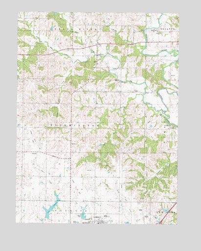
Lamoni North, IA USGS Topographic Map
Click on map above to begin viewing in our Map Viewer.

This topographic map contains these locations and features:
Feature Name Type Latitude Longitude GNIS ID View Map
Bloomington ChurchChurchN40.6722°W93.9563°1822798View Map
Bucy CemeteryCemeteryN40.6905°W93.8894°1822799View Map
Cash CemeteryCemeteryN40.7325°W93.8833°1822801View Map
Creveling CemeteryCemeteryN40.6305°W93.8989°1822788View Map
ElkLocaleN40.7175°W93.9397°466372View Map
Elk CemeteryCemeteryN40.7208°W93.9389°1822802View Map
Elk ChapelChurchN40.7314°W93.9383°1822803View Map
Elk CreekStreamN40.6917°W93.8863°456289View Map
Elk Post Office (historical)Post OfficeN40.7306°W93.9377°1969586View Map
Foreman City ParkParkN40.6292°W93.9330°1822790View Map
Grand River BridgeBridgeN40.7217°W93.8761°1969650View Map
Home LakeReservoirN40.6302°W93.9478°1822794View Map
Home PondReservoirN40.6257°W93.9520°1822795View Map
Lake LaShaneReservoirN40.6346°W93.9723°1822793View Map
Lamoni Elementary SchoolSchoolN40.6253°W93.9359°1969647View Map
Lamoni Municipal AirportAirportN40.6298°W93.9007°466848View Map
Lillie CemeteryCemeteryN40.6566°W93.9416°1822792View Map
Millsap CemeteryCemeteryN40.7333°W93.9502°1969692View Map
Pot Hole CreekStreamN40.7017°W93.9024°1822796View Map
Solly's Strip Ultralight FlightparkAirportN40.6509°W93.9583°2677147View Map
South Elk CreekStreamN40.7261°W93.9424°1822800View Map
Terre Haute CemeteryCemeteryN40.6836°W93.8798°1822797View Map
Township of BloomingtonCivilN40.6814°W93.9582°467466View Map
Tuskeega (historical)LocaleN40.6672°W93.9838°1969574View Map
Tuskeega Post Office (historical)Post OfficeN40.6672°W93.9838°1969573View Map
TuskeegoPopulated PlaceN40.6667°W93.9841°1822791View Map
United Methodist ChurchChurchN40.6261°W93.9322°1969641View Map
West Elk CreekStreamN40.7264°W93.9430°1822960View Map
Woodmansee CemeteryCemeteryN40.7405°W93.8942°1822804View Map

Note: Coordinates in the location and feature list above are referenced to NAD83 datum.


Copyright (C) 2008-2025 Ryan Niemi / Sunset Dynamics ... All Rights Reserved