TopoQuest Logo
Do you find TopoQuest useful?
Help keep TopoQuest running and adding new maps/features by donating!
Bitcoin:  19c7KJd3qBynnjoSw5npx9KScwjBe4ifkT
Litecoin:  LXs6TkuXGGXo1vDsWCkWVdjQX94eUKd6ui
Home View Maps Find Maps Find Places Resources & Links


Daylight, Indiana Topographic Map

USGS Map Title: Daylight, IN
USGS Map MRC: 38087A4
DRG (GeoTIFF) Download: o38087a4.tif


Neighboring USGS Topographic Map Quads:


  Haubstadt, IN  
38087B5
 

  Elberfeld, IN  
38087B4
 

  Lynnville, IN  
38087B3
 

  Evansville North, IN  
38087A5
 

  Daylight, IN  
38087A4
 

  Boonville, IN  
38087A3
 

  Evansville South, IN  
37087H5
 

  Newburgh, IN  
37087H4
 

  Yankeetown, IN  
37087H3


Map MRC Location:

N39°
W88°
N39°
W87°
H8 H7 H6 H5 H4 H3 H2 H1
G8 G7 G6 G5 G4 G3 G2 G1
F8 F7 F6 F5 F4 F3 F2 F1
E8 E7 E6 E5 E4 E3 E2 E1
D8 D7 D6 D5 D4 D3 D2 D1
C8 C7 C6 C5 C4 C3 C2 C1
B8 B7 B6 B5 B4 B3 B2 B1
A8 A7 A6 A5 A4 A3 A2 A1
N38°
W88°
N38°
W87°

Daylight, IN USGS 1:24K Topographic Map Preview:
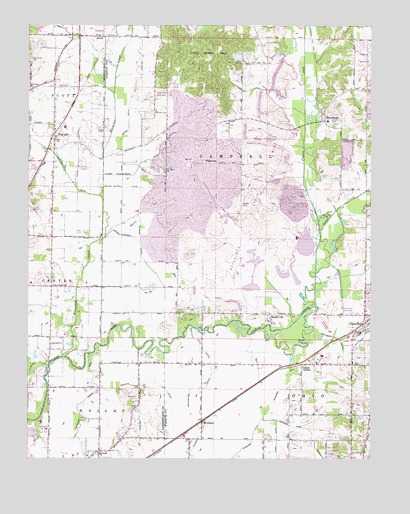
Daylight, IN USGS Topographic Map
Click on map above to begin viewing in our Map Viewer.

This topographic map contains these locations and features:
Feature Name Type Latitude Longitude GNIS ID View Map
Angel DitchCanalN38.0056°W87.4092°430175View Map
Asbury CemeteryCemeteryN38.0734°W87.4222°430289View Map
Barnes DitchCanalN38.0500°W87.4356°430504View Map
Baugh CityPopulated PlaceN38.0417°W87.4125°430586View Map
Blue Grass CemeteryCemeteryN38.1153°W87.4989°431224View Map
Blue Grass ChurchChurchN38.1067°W87.4995°431225View Map
Bluegrass CreekStreamN38.0292°W87.4872°431257View Map
Boesche DitchCanalN38.0206°W87.4750°431283View Map
Brinkmeyer DitchCanalN38.0275°W87.4333°431532View Map
Burkhardt SchoolSchoolN38.0020°W87.4742°431837View Map
Castle GardenPopulated PlaceN38.0275°W87.3992°432226View Map
Crawford Brandeis DitchCanalN38.0131°W87.4822°433096View Map
DaylightPopulated PlaceN38.0937°W87.4906°433368View Map
Dennis Klippel DitchCanalN38.0809°W87.4650°433474View Map
Dennis Wagner DitchCanalN38.0584°W87.4583°433476View Map
ElliottPopulated PlaceN38.1217°W87.4728°434097View Map
Euler BranchStreamN38.0642°W87.4631°434246View Map
Fehd DitchCanalN38.0323°W87.4361°434433View Map
Firlick CreekStreamN38.0373°W87.4675°434496View Map
FishervillePopulated PlaceN38.0853°W87.4331°434528View Map
Gardner Webb DitchCanalN38.0092°W87.4017°434955View Map
Hansen Ditch (historical)CanalN38.0467°W87.4181°435701View Map
Howard DitchCanalN38.0112°W87.4353°436538View Map
Knight Township Fire Department Company 6 (historical)BuildingN38.0011°W87.4744°2626423View Map
Licking CreekStreamN38.0270°W87.4931°437874View Map
Little Ditney HillSummitN38.1067°W87.4339°438045View Map
MillersburgPopulated PlaceN38.0978°W87.3997°439232View Map
Perdido Lake (historical)ReservoirN38.0350°W87.4133°441015View Map
Raceway AirportAirportN38.0529°W87.3791°2677047View Map
Saint JohnPopulated PlaceN38.0792°W87.4500°446750View Map
Saint Johns ChurchChurchN38.0823°W87.4503°442584View Map
Schlensker DitchCanalN38.0823°W87.4856°443075View Map
Scott Township Volunteer Fire Department Station 2BuildingN38.0905°W87.4901°2626570View Map
Squaw CreekStreamN38.0637°W87.3936°444032View Map
StevensonPopulated PlaceN38.0167°W87.4333°444139View Map
Stollberg DitchCanalN38.0370°W87.3958°444193View Map
Stubbs Fruedenberg DitchCanalN38.0856°W87.4583°444282View Map
Township of CampbellCivilN38.0925°W87.4156°453156View Map
Weinsheimer DitchCanalN38.0278°W87.4028°445641View Map
Woods DitchCanalN38.0973°W87.4636°446314View Map
Zoar ChurchChurchN38.0856°W87.4411°446491View Map

Note: Coordinates in the location and feature list above are referenced to NAD83 datum.


Copyright (C) 2008-2024 Ryan Niemi / Sunset Dynamics ... All Rights Reserved