TopoQuest Logo
Do you find TopoQuest useful?
Help keep TopoQuest running and adding new maps/features by donating!
Bitcoin:  19c7KJd3qBynnjoSw5npx9KScwjBe4ifkT
Litecoin:  LXs6TkuXGGXo1vDsWCkWVdjQX94eUKd6ui
Home View Maps Find Maps Find Places Resources & Links


Elberfeld, Indiana Topographic Map

USGS Map Title: Elberfeld, IN
USGS Map MRC: 38087B4
DRG (GeoTIFF) Download: o38087b4.tif


Neighboring USGS Topographic Map Quads:


  Princeton, IN  
38087C5
 

  Francisco, IN  
38087C4
 

  Oakland City, IN  
38087C3
 

  Haubstadt, IN  
38087B5
 

  Elberfeld, IN  
38087B4
 

  Lynnville, IN  
38087B3
 

  Evansville North, IN  
38087A5
 

  Daylight, IN  
38087A4
 

  Boonville, IN  
38087A3


Map MRC Location:

N39°
W88°
N39°
W87°
H8 H7 H6 H5 H4 H3 H2 H1
G8 G7 G6 G5 G4 G3 G2 G1
F8 F7 F6 F5 F4 F3 F2 F1
E8 E7 E6 E5 E4 E3 E2 E1
D8 D7 D6 D5 D4 D3 D2 D1
C8 C7 C6 C5 C4 C3 C2 C1
B8 B7 B6 B5 B4 B3 B2 B1
A8 A7 A6 A5 A4 A3 A2 A1
N38°
W88°
N38°
W87°

Elberfeld, IN USGS 1:24K Topographic Map Preview:
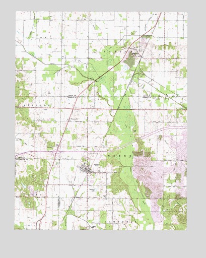
Elberfeld, IN USGS Topographic Map
Click on map above to begin viewing in our Map Viewer.

This topographic map contains these locations and features:
Feature Name Type Latitude Longitude GNIS ID View Map
Bell Conservation LakeReservoirN38.1501°W87.4932°447830View Map
Bell Conservation Lake DamDamN38.1500°W87.4917°447829View Map
Big CreekStreamN38.1981°W87.4275°431026View Map
BuckskinPopulated PlaceN38.2284°W87.4120°431754View Map
Buckskin Barton Township Volunteer Fire DepartmentBuildingN38.2230°W87.4061°2626432View Map
Clear BranchStreamN38.1300°W87.3992°432603View Map
Donohue CreekStreamN38.2353°W87.3778°433637View Map
ElberfeldPopulated PlaceN38.1598°W87.4483°434059View Map
Elberfeld MineMineN38.1259°W87.4445°434060View Map
Elberfeld Town MarshalBuildingN38.1606°W87.4476°2758439View Map
Elberfeld Volunteer Fire DepartmentBuildingN38.1589°W87.4456°2626448View Map
Halfmoon CreekStreamN38.2364°W87.4081°435604View Map
Lost HillSummitN38.1825°W87.4128°438324View Map
Nobles CemeteryCemeteryN38.1725°W87.4731°440190View Map
Nobles ChapelChurchN38.1731°W87.4678°440191View Map
Northview CemeteryCemeteryN38.1661°W87.4481°440335View Map
Oakdam Post Office (historical)Post OfficeN38.1317°W87.4803°452983View Map
RosebudPopulated PlaceN38.1945°W87.4125°452101View Map
Smith ForkStreamN38.2053°W87.4331°443692View Map
Snake RunStreamN38.2262°W87.4906°443725View Map
Susett CemeteryCemeteryN38.1434°W87.4339°444441View Map
Tabor ChurchChurchN38.1953°W87.4989°444539View Map
Town of ElberfeldCivilN38.1617°W87.4482°2396923View Map
Township of BartonCivilN38.2455°W87.3915°453097View Map
Township of GreerCivilN38.1686°W87.4110°453356View Map
Warrens LakeLakeN38.1481°W87.4416°445484View Map
WheatonvillePopulated PlaceN38.1873°W87.4614°445880View Map
Williams CemeteryCemeteryN38.1945°W87.4567°446061View Map
Zion CemeteryCemeteryN38.1584°W87.4397°446442View Map

Note: Coordinates in the location and feature list above are referenced to NAD83 datum.


Copyright (C) 2008-2024 Ryan Niemi / Sunset Dynamics ... All Rights Reserved