TopoQuest Logo
Do you find TopoQuest useful?
Help keep TopoQuest running and adding new maps/features by donating!
Bitcoin:  19c7KJd3qBynnjoSw5npx9KScwjBe4ifkT
Litecoin:  LXs6TkuXGGXo1vDsWCkWVdjQX94eUKd6ui
Home View Maps Find Maps Find Places Resources & Links


De Queen, Arkansas Topographic Map

USGS Map Title: De Queen, AR
USGS Map MRC: 34094A3
DRG (GeoTIFF) Download: o34094a3.tif


Neighboring USGS Topographic Map Quads:


  De Queen NW, AR  
34094B4
 

  Gillham, AR  
34094B3
 

  Gillham Dam, AR  
34094B2
 

  Chapel Hill, AR  
34094A4
 

  De Queen, AR  
34094A3
 

  Geneva, AR  
34094A2
 

  Cerrogordo, AR  
33094H4
 

  Horatio, AR  
33094H3
 

  Lockesburg, AR  
33094H2


Map MRC Location:

N35°
W95°
N35°
W94°
H8 H7 H6 H5 H4 H3 H2 H1
G8 G7 G6 G5 G4 G3 G2 G1
F8 F7 F6 F5 F4 F3 F2 F1
E8 E7 E6 E5 E4 E3 E2 E1
D8 D7 D6 D5 D4 D3 D2 D1
C8 C7 C6 C5 C4 C3 C2 C1
B8 B7 B6 B5 B4 B3 B2 B1
A8 A7 A6 A5 A4 A3 A2 A1
N34°
W95°
N34°
W94°

De Queen, AR USGS 1:24K Topographic Map Preview:
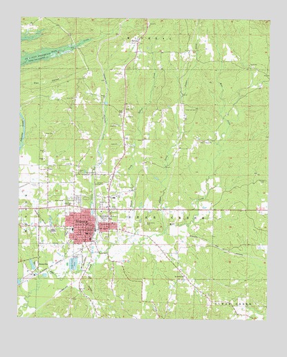
De Queen, AR USGS Topographic Map
Click on map above to begin viewing in our Map Viewer.

This topographic map contains these locations and features:
Feature Name Type Latitude Longitude GNIS ID View Map
AvonPopulated PlaceN34.0748°W94.3230°76216View Map
Avon CemeteryCemeteryN34.0862°W94.3233°45990View Map
Avon School (historical)SchoolN34.0854°W94.3249°67394View Map
Baker School (historical)SchoolN34.0465°W94.2780°67386View Map
Bear Creek JunctionLocaleN34.0473°W94.3391°67398View Map
Center Grove School (historical)SchoolN34.1157°W94.2755°67391View Map
Christian Home Church (historical)ChurchN34.0559°W94.3658°67396View Map
City of De QueenCivilN34.0427°W94.3423°2404202View Map
Community Hospital of De Queen HeliportAirportN34.0473°W94.3549°83675View Map
Cross Trail CemeteryCemeteryN34.0876°W94.2869°48208View Map
Cross Trail School (historical)SchoolN34.0868°W94.2869°67390View Map
Cross Trails (historical)Populated PlaceN34.0876°W94.2860°67389View Map
De QueenPopulated PlaceN34.0379°W94.3413°66997View Map
De Queen Elementary SchoolSchoolN34.0286°W94.3612°2039322View Map
De Queen Fire StationBuildingN34.0382°W94.3395°2116345View Map
De Queen High SchoolSchoolN34.0298°W94.3588°2039318View Map
De Queen Landing Strip (historical)AirportN34.0557°W94.3327°67408View Map
De Queen Manor Nursing HomeBuildingN34.0473°W94.3513°67405View Map
De Queen Middle SchoolSchoolN34.0304°W94.3598°2039319View Map
De Queen Police DepartmentBuildingN34.0385°W94.3386°2118956View Map
De Queen Post OfficePost OfficeN34.0371°W94.3416°84394View Map
De Queen Primary SchoolSchoolN34.0399°W94.3282°2039323View Map
De Queen Regional Medical CenterHospitalN34.0479°W94.3527°67406View Map
Fairview CemeteryCemeteryN34.0582°W94.2519°48967View Map
Fairview Church (historical)ChurchN34.0584°W94.2519°67387View Map
Herman Direk Memorial ParkCemeteryN34.0421°W94.3316°50026View Map
KDQN-AM (De Queen)TowerN34.0326°W94.3288°85069View Map
KDQN-FM (De Queen)TowerN34.0326°W94.3288°85172View Map
Lifenet, Incorporated - De Queen (Ambulance Services)BuildingN34.0459°W94.3239°2119054View Map
Little Bear CreekStreamN34.0279°W94.3333°51191View Map
Mount Pleasant ChurchChurchN34.0179°W94.2916°52397View Map
Mount Pleasant School (historical)SchoolN34.0187°W94.2924°67385View Map
Pepper CreekStreamN34.0371°W94.3016°53282View Map
Piney Grove School (historical)SchoolN34.0009°W94.3505°67397View Map
Process CityPopulated PlaceN34.0212°W94.3655°58434View Map
Process City LakeReservoirN34.0220°W94.3679°80681View Map
Process City Lake DamDamN34.0201°W94.3669°80680View Map
PullmanPopulated PlaceN34.1146°W94.3166°58445View Map
Pullman Methodist Church (historical)ChurchN34.1148°W94.3163°67392View Map
Pullman School (historical)SchoolN34.1148°W94.3163°67393View Map
Redman CemeteryCemeteryN34.0373°W94.3580°78149View Map
Ridgeview Lodge Nursing HomeBuildingN34.0487°W94.3424°67404View Map
Sevier County CourthouseBuildingN34.0373°W94.3408°67402View Map
Sevier County Sheriff OfficeBuildingN34.0372°W94.3409°2118954View Map
Smyrna CemeteryCemeteryN34.0737°W94.2827°67388View Map
Smyrna Church of ChristChurchN34.0743°W94.2824°78389View Map
South Central Arkansas Drug Task ForceBuildingN34.0372°W94.3409°2118955View Map
Southwest Emergency Medical Service DeQueenBuildingN34.0457°W94.3430°2119053View Map
Sweet Home CemeteryCemeteryN34.0398°W94.3113°55383View Map
Town North Shopping CenterLocaleN34.0462°W94.3419°67403View Map
Township of Bear CreekCivilN34.0508°W94.2882°69122View Map
UnionPopulated PlaceN34.0615°W94.3610°58783View Map
Union ChurchChurchN34.0643°W94.3488°78613View Map
Union School (historical)SchoolN34.0784°W94.3555°67395View Map
Wilson CreekStreamN34.0334°W94.3194°56439View Map

Note: Coordinates in the location and feature list above are referenced to NAD83 datum.


Copyright (C) 2008-2024 Ryan Niemi / Sunset Dynamics ... All Rights Reserved