TopoQuest Logo
Do you find TopoQuest useful?
Help keep TopoQuest running and adding new maps/features by donating!
Bitcoin:  19c7KJd3qBynnjoSw5npx9KScwjBe4ifkT
Litecoin:  LXs6TkuXGGXo1vDsWCkWVdjQX94eUKd6ui
Home View Maps Find Maps Find Places Resources & Links


Gillham Dam, Arkansas Topographic Map

USGS Map Title: Gillham Dam, AR
USGS Map MRC: 34094B2
DRG (GeoTIFF) Download: o34094b2.tif


Neighboring USGS Topographic Map Quads:


  Wickes, AR  
34094C3
 

  Baker Springs, AR  
34094C2
 

  Umpire, AR  
34094C1
 

  Gillham, AR  
34094B3
 

  Gillham Dam, AR  
34094B2
 

  Dierks Dam, AR  
34094B1
 

  De Queen, AR  
34094A3
 

  Geneva, AR  
34094A2
 

  Dierks, AR  
34094A1


Map MRC Location:

N35°
W95°
N35°
W94°
H8 H7 H6 H5 H4 H3 H2 H1
G8 G7 G6 G5 G4 G3 G2 G1
F8 F7 F6 F5 F4 F3 F2 F1
E8 E7 E6 E5 E4 E3 E2 E1
D8 D7 D6 D5 D4 D3 D2 D1
C8 C7 C6 C5 C4 C3 C2 C1
B8 B7 B6 B5 B4 B3 B2 B1
A8 A7 A6 A5 A4 A3 A2 A1
N34°
W95°
N34°
W94°

Gillham Dam, AR USGS 1:24K Topographic Map Preview:
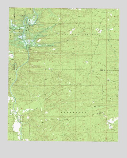
Gillham Dam, AR USGS Topographic Map
Click on map above to begin viewing in our Map Viewer.

This topographic map contains these locations and features:
Feature Name Type Latitude Longitude GNIS ID View Map
Almond CreekStreamN34.1457°W94.2394°45843View Map
Antimony (historical)Populated PlaceN34.1932°W94.2060°62520View Map
Antimony School (historical)SchoolN34.1804°W94.2069°67375View Map
Carters CreekStreamN34.1896°W94.2416°47499View Map
Cedar Glade (historical)Populated PlaceN34.2140°W94.1569°62549View Map
Cedar Glade School (historical)SchoolN34.2179°W94.2208°62550View Map
Clinton FordCrossingN34.1673°W94.2449°67374View Map
Coon CreekStreamN34.2298°W94.2330°47996View Map
Cooper School (historical)SchoolN34.1343°W94.2127°67369View Map
Cossatot CemeteryCemeteryN34.1487°W94.2338°48062View Map
Cossatot Church (historical)ChurchN34.1484°W94.2335°67372View Map
Dalrymple Ford (historical)CrossingN34.2321°W94.2321°62567View Map
Flanagan FordCrossingN34.1612°W94.2416°67373View Map
French CreekStreamN34.2196°W94.2224°49242View Map
Gillham DamDamN34.2104°W94.2285°74844View Map
Gillham LakeReservoirN34.2270°W94.2301°74845View Map
Graves School (historical)SchoolN34.1676°W94.1758°67376View Map
Howard County State Wildlife Management AreaParkN34.2446°W94.1419°62605View Map
Hunters CreekStreamN34.2068°W94.2277°77257View Map
Hurricane CreekStreamN34.1421°W94.2355°50437View Map
Ladd FordCrossingN34.1446°W94.2388°67370View Map
Ladds BridgeBridgeN34.1446°W94.2388°67371View Map
Mallon Ford (historical)CrossingN34.2223°W94.2346°62613View Map
New Hope ChurchChurchN34.1515°W94.1474°52677View Map
Newhope School (historical)SchoolN34.1509°W94.1474°67377View Map
Old New Hope CemeteryCemeteryN34.1517°W94.1478°2574018View Map
Pleasant Ridge School (historical)SchoolN34.2137°W94.1560°62655View Map
Roundtop School (historical)SchoolN34.1776°W94.1266°67378View Map
Smyrna (historical)Populated PlaceN34.2421°W94.1696°62683View Map
Striklin CreekStreamN34.2159°W94.2210°78475View Map
Sycamore CreekStreamN34.1807°W94.2430°55405View Map
Three Shoot FordCrossingN34.2143°W94.2308°78551View Map
Township of JeffersonCivilN34.1425°W94.1627°69126View Map
Township of Sulphur Springs (historical)CivilN34.2334°W94.1433°63143View Map
Valley Ridge (historical)Populated PlaceN34.2179°W94.2213°62696View Map
Valley Ridge School (historical)SchoolN34.2421°W94.1699°62706View Map
Wiser Ford (historical)CrossingN34.2432°W94.2180°62711View Map

Note: Coordinates in the location and feature list above are referenced to NAD83 datum.


Copyright (C) 2008-2025 Ryan Niemi / Sunset Dynamics ... All Rights Reserved