TopoQuest Logo
Do you find TopoQuest useful?
Help keep TopoQuest running and adding new maps/features by donating!
Bitcoin:  19c7KJd3qBynnjoSw5npx9KScwjBe4ifkT
Litecoin:  LXs6TkuXGGXo1vDsWCkWVdjQX94eUKd6ui
Home View Maps Find Maps Find Places Resources & Links


Cerrogordo, Arkansas Topographic Map

USGS Map Title: Cerrogordo, AR
USGS Map MRC: 33094H4
DRG (GeoTIFF) Download: o33094h4.tif


Neighboring USGS Topographic Map Quads:


  Eagletown, OK  
34094A5
 

  Chapel Hill, AR  
34094A4
 

  De Queen, AR  
34094A3
 

  Goodwater, OK  
33094H5
 

  Cerrogordo, AR  
33094H4
 

  Horatio, AR  
33094H3
 

  Bokhoma, OK  
33094G5
 

  Arkinda, AR  
33094G4
 

  Winthrop, AR  
33094G3


Map MRC Location:

N34°
W95°
N34°
W94°
H8 H7 H6 H5 H4 H3 H2 H1
G8 G7 G6 G5 G4 G3 G2 G1
F8 F7 F6 F5 F4 F3 F2 F1
E8 E7 E6 E5 E4 E3 E2 E1
D8 D7 D6 D5 D4 D3 D2 D1
C8 C7 C6 C5 C4 C3 C2 C1
B8 B7 B6 B5 B4 B3 B2 B1
A8 A7 A6 A5 A4 A3 A2 A1
N33°
W95°
N33°
W94°

Cerrogordo, AR USGS 1:24K Topographic Map Preview:
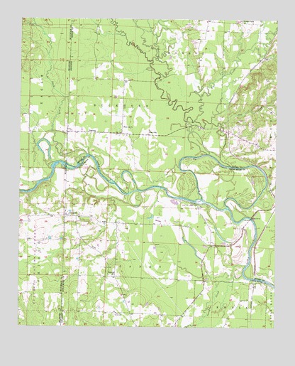
Cerrogordo, AR USGS Topographic Map
Click on map above to begin viewing in our Map Viewer.

This topographic map contains these locations and features:
Feature Name Type Latitude Longitude GNIS ID View Map
Bear CreekStreamN33.9587°W94.4147°70552View Map
Billingsleys CornerPopulated PlaceN33.9082°W94.4072°60085View Map
Boring CrossingCrossingN33.9709°W94.4305°67330View Map
Buck CreekStreamN33.9450°W94.4676°70889View Map
Caney CreekStreamN33.8965°W94.3910°70994View Map
Cerro Gordo Volunteer Fire DepartmentBuildingN33.9198°W94.4760°2116256View Map
CerrogordoPopulated PlaceN33.9198°W94.4760°76580View Map
Cerrogordo CemeteryCemeteryN33.9215°W94.4741°60094View Map
Dog Town BridgeBridgeN33.9757°W94.4344°67331View Map
DogtownLocaleN33.9543°W94.4666°71402View Map
Gin House FordCrossingN33.9446°W94.4066°67329View Map
Green Wood Ferry (historical)CrossingN33.9176°W94.3941°67328View Map
Green Wood ShoalsBarN33.8962°W94.3902°75290View Map
Line FordCrossingN33.9401°W94.4758°67317View Map
Little River Country ClubLocaleN33.9254°W94.4135°82499View Map
Morris Ferry (historical)Populated PlaceN33.8884°W94.3858°60143View Map
Old Channel Little RiverStreamN33.9240°W94.3980°72928View Map
Parker CrossingCrossingN33.9334°W94.4558°67333View Map
Pauley CemeteryCemeteryN33.8807°W94.4530°73020View Map
Plainview SchoolSchoolN33.8959°W94.4544°73117View Map
Rock CreekStreamN33.9837°W94.4349°73331View Map
Rolling ForkStreamN33.9407°W94.3969°73372View Map
Sand CreekStreamN33.9576°W94.4019°73471View Map
Sorghum Patch FordCrossingN33.9318°W94.4313°67332View Map
State Line Baptist ChurchChurchN33.9196°W94.4769°60180View Map
Township of BuckhornCivilN33.9642°W94.4485°69124View Map
Township of CaneyCivilN33.9029°W94.4383°66834View Map
WadePopulated PlaceN33.9843°W94.3827°73974View Map
West OtisPopulated PlaceN33.9532°W94.4363°74078View Map
West Otis CemeteryCemeteryN33.9526°W94.4519°67340View Map
West Otis ChurchChurchN33.9562°W94.4491°74079View Map
Wright ChapelChurchN33.9998°W94.3910°78811View Map

Note: Coordinates in the location and feature list above are referenced to NAD83 datum.


Copyright (C) 2008-2025 Ryan Niemi / Sunset Dynamics ... All Rights Reserved