TopoQuest Logo
Do you find TopoQuest useful?
Help keep TopoQuest running and adding new maps/features by donating!
Bitcoin:  19c7KJd3qBynnjoSw5npx9KScwjBe4ifkT
Litecoin:  LXs6TkuXGGXo1vDsWCkWVdjQX94eUKd6ui
Home View Maps Find Maps Find Places Resources & Links


De Witt, Arkansas Topographic Map

USGS Map Title: De Witt, AR
USGS Map MRC: 34091C3
DRG (GeoTIFF) Download: o34091c3.tif


Neighboring USGS Topographic Map Quads:


  Almyra, AR  
34091D4
 

  De Witt NE, AR  
34091D3
 

  Crocketts Bluff, AR  
34091D2
 

  De Witt SW, AR  
34091C4
 

  De Witt, AR  
34091C3
 

  Ethel, AR  
34091C2
 

  One Horse Store, AR  
34091B4
 

  Tichnor, AR  
34091B3
 

  Weber, AR  
34091B2


Map MRC Location:

N35°
W92°
N35°
W91°
H8 H7 H6 H5 H4 H3 H2 H1
G8 G7 G6 G5 G4 G3 G2 G1
F8 F7 F6 F5 F4 F3 F2 F1
E8 E7 E6 E5 E4 E3 E2 E1
D8 D7 D6 D5 D4 D3 D2 D1
C8 C7 C6 C5 C4 C3 C2 C1
B8 B7 B6 B5 B4 B3 B2 B1
A8 A7 A6 A5 A4 A3 A2 A1
N34°
W92°
N34°
W91°

De Witt, AR USGS 1:24K Topographic Map Preview:
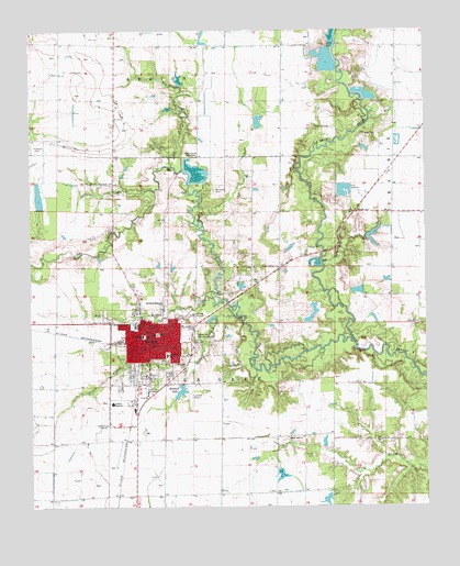
De Witt, AR USGS Topographic Map
Click on map above to begin viewing in our Map Viewer.

This topographic map contains these locations and features:
Feature Name Type Latitude Longitude GNIS ID View Map
Alter LakeReservoirN34.2583°W91.2962°80830View Map
Alter Lake DamDamN34.2584°W91.2968°80829View Map
Alter Lake Number TwoReservoirN34.2634°W91.3001°80837View Map
Alter Lake Number Two DamDamN34.2634°W91.3001°80836View Map
Arkansas CountyCivilN34.2908°W91.3749°63755View Map
Arkansas County CourthouseBuildingN34.2954°W91.3351°62154View Map
Arkansas County Sheriff's Office Southern DistrictBuildingN34.2721°W91.3447°2118590View Map
Arkansas Noname 288 DamDamN34.3068°W91.2701°80835View Map
Big La Grue CemeteryCemeteryN34.2981°W91.2515°46579View Map
Cedarcrest Memorial GardensCemeteryN34.2951°W91.3234°76563View Map
Center School (historical)SchoolN34.3268°W91.2607°62171View Map
Church of the First BornChurchN34.3420°W91.3226°47773View Map
City of DeWittCivilN34.2874°W91.3383°2404205View Map
De WittPopulated PlaceN34.2929°W91.3379°48411View Map
De Witt CemeteryCemeteryN34.2851°W91.3409°62183View Map
De Witt City Hospital HeliportAirportN34.2793°W91.3387°83678View Map
De Witt City Nursing HomeBuildingN34.2801°W91.3385°62185View Map
De Witt Fire StationBuildingN34.2967°W91.3356°2116347View Map
De Witt High SchoolSchoolN34.2770°W91.3498°48412View Map
De Witt Middle SchoolSchoolN34.2976°W91.3421°62186View Map
De Witt Municipal Airport Whitcomb FieldAirportN34.2667°W91.3087°83679View Map
De Witt Police DepartmentBuildingN34.2960°W91.3359°2118591View Map
De Witt Post OfficePost OfficeN34.2951°W91.3373°84110View Map
De Witt Public LibraryBuildingN34.2970°W91.3368°62187View Map
Dewitt City HospitalHospitalN34.2794°W91.3384°62184View Map
Dewitt High SchoolSchoolN34.2773°W91.3494°2039289View Map
Dewitt Middle SchoolSchoolN34.2975°W91.3419°2039288View Map
Ditch Number 3CanalN34.2668°W91.3682°62260View Map
Elm BranchStreamN34.3395°W91.3307°48867View Map
First Christian ChurchChurchN34.2951°W91.3385°62195View Map
First United Methodist ChurchChurchN34.2951°W91.3379°62198View Map
Fork of LaGrue CemeteryCemeteryN34.3123°W91.2954°62201View Map
Fork of LaGrue School (historical)SchoolN34.3126°W91.2971°62202View Map
Forks La Grue ChurchChurchN34.3129°W91.2968°76950View Map
Gaines School (historical)SchoolN34.3712°W91.2951°62208View Map
Herns CemeteryCemeteryN34.2634°W91.2862°50029View Map
Holt BranchStreamN34.3048°W91.3173°50265View Map
Jackson CemeteryCemeteryN34.3562°W91.2623°50555View Map
KDEW-AM (De Witt)TowerN34.2693°W91.3507°85071View Map
KDEW-FM (De Witt)TowerN34.2693°W91.3507°85173View Map
Lakeside Airport (historical)AirportN34.2784°W91.3243°65007View Map
Little LaGrue BayouStreamN34.2932°W91.2735°51293View Map
Malone CemeteryCemeteryN34.3479°W91.2701°51629View Map
McCowan CemeteryCemeteryN34.3331°W91.3171°51804View Map
McDaniel CemeteryCemeteryN34.3345°W91.3493°51816View Map
McKenzie CemeteryCemeteryN34.3495°W91.2854°51857View Map
McKewen LakeReservoirN34.2997°W91.2863°80834View Map
McKewen Lake DamDamN34.3034°W91.2851°80833View Map
Miller LakeReservoirN34.2801°W91.2968°80832View Map
Miller Lake DamDamN34.2801°W91.2968°80831View Map
Mitchell LakeReservoirN34.2802°W91.3279°75026View Map
Mitchell Lake DamDamN34.2820°W91.3282°80828View Map
Morning Glory CemeteryCemeteryN34.2843°W91.3401°62247View Map
Northside MissionChurchN34.3037°W91.3337°52846View Map
Oakhills Country ClubLocaleN34.3001°W91.3526°62271View Map
Prices BranchStreamN34.2998°W91.3107°78098View Map
Ricebelt Vocational Technical SchoolSchoolN34.2723°W91.3496°62291View Map
Southside Elementary SchoolSchoolN34.2896°W91.3323°83510View Map
Sunny Side ChurchChurchN34.2682°W91.2943°55338View Map
Sunny Side School (historical)SchoolN34.2673°W91.2723°62313View Map
Thompson CemeteryCemeteryN34.3437°W91.3740°55534View Map
Thomwall (historical)Populated PlaceN34.2676°W91.3448°62317View Map
Township of La GrueCivilN34.2823°W91.3435°63664View Map
Union LakeReservoirN34.2518°W91.2819°81297View Map
Union Lake DamDamN34.2518°W91.2818°81296View Map
Westside Elementary SchoolSchoolN34.2948°W91.3398°83530View Map

Note: Coordinates in the location and feature list above are referenced to NAD83 datum.


Copyright (C) 2008-2025 Ryan Niemi / Sunset Dynamics ... All Rights Reserved