TopoQuest Logo
Do you find TopoQuest useful?
Help keep TopoQuest running and adding new maps/features by donating!
Bitcoin:  19c7KJd3qBynnjoSw5npx9KScwjBe4ifkT
Litecoin:  LXs6TkuXGGXo1vDsWCkWVdjQX94eUKd6ui
Home View Maps Find Maps Find Places Resources & Links


Tichnor, Arkansas Topographic Map

USGS Map Title: Tichnor, AR
USGS Map MRC: 34091B3
DRG (GeoTIFF) Download: o34091b3.tif


Neighboring USGS Topographic Map Quads:


  De Witt SW, AR  
34091C4
 

  De Witt, AR  
34091C3
 

  Ethel, AR  
34091C2
 

  One Horse Store, AR  
34091B4
 

  Tichnor, AR  
34091B3
 

  Weber, AR  
34091B2
 

  Gillett, AR  
34091A4
 

  Arkansas Post, AR  
34091A3
 

  Henrico SW, AR  
34091A2


Map MRC Location:

N35°
W92°
N35°
W91°
H8 H7 H6 H5 H4 H3 H2 H1
G8 G7 G6 G5 G4 G3 G2 G1
F8 F7 F6 F5 F4 F3 F2 F1
E8 E7 E6 E5 E4 E3 E2 E1
D8 D7 D6 D5 D4 D3 D2 D1
C8 C7 C6 C5 C4 C3 C2 C1
B8 B7 B6 B5 B4 B3 B2 B1
A8 A7 A6 A5 A4 A3 A2 A1
N34°
W92°
N34°
W91°

Tichnor, AR USGS 1:24K Topographic Map Preview:
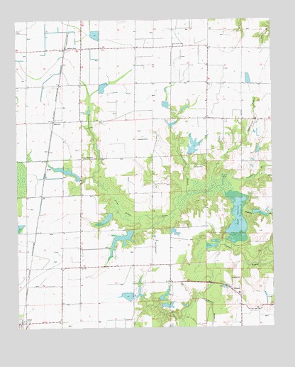
Tichnor, AR USGS Topographic Map
Click on map above to begin viewing in our Map Viewer.

This topographic map contains these locations and features:
Feature Name Type Latitude Longitude GNIS ID View Map
Botts LakeReservoirN34.1892°W91.3526°80883View Map
Botts Lake DamDamN34.1884°W91.3485°80882View Map
Brown School (historical)SchoolN34.1945°W91.3087°62164View Map
Buffo (historical)Populated PlaceN34.1557°W91.3679°62167View Map
Camp DoughboyLocaleN34.1937°W91.3432°76507View Map
Campground BranchStreamN34.1790°W91.2912°47356View Map
Childers CemeteryCemeteryN34.1909°W91.2873°47738View Map
Childers Lake DamDamN34.1951°W91.2901°80880View Map
Childers Lake DamReservoirN34.1951°W91.2901°80881View Map
Conine CemeteryCemeteryN34.1618°W91.2865°47960View Map
Deluce-Prairie Union ChurchChurchN34.2395°W91.2976°76780View Map
Fletchers BranchStreamN34.1823°W91.2707°45744View Map
Gregory LakeReservoirN34.1705°W91.3299°80875View Map
Gregory Lake DamDamN34.1718°W91.3301°80874View Map
Halliburton BranchStreamN34.1868°W91.2790°49790View Map
Hostetter School (historical)SchoolN34.1509°W91.3093°62223View Map
HydenPopulated PlaceN34.1890°W91.3610°57963View Map
Indiana SpurLocaleN34.2387°W91.3507°77271View Map
Jenkins LakeReservoirN34.1713°W91.2562°80877View Map
Jenkins Lake DamDamN34.1718°W91.2601°80876View Map
La Fargue LakeReservoirN34.1866°W91.3459°80879View Map
La Fargue Lake DamDamN34.1851°W91.3451°80878View Map
La Fargue School (historical)SchoolN34.1934°W91.3443°62232View Map
Lake WisdomReservoirN34.1392°W91.3158°80871View Map
Lake Wisdom DamDamN34.1384°W91.3151°80870View Map
Lone Star ChurchChurchN34.1445°W91.2704°51402View Map
Lowe LakeReservoirN34.1606°W91.3245°80873View Map
Lowe Lake DamDamN34.1634°W91.3185°80872View Map
MayviewPopulated PlaceN34.2093°W91.3568°57108View Map
McCracken LakeReservoirN34.1381°W91.3034°80885View Map
McCracken Lake DamDamN34.1368°W91.3051°80884View Map
Point Deluce BayouStreamN34.1795°W91.2732°53642View Map
Prairie UnionPopulated PlaceN34.2390°W91.2987°62285View Map
Prairie Union School (historical)SchoolN34.2393°W91.2990°62286View Map
Ruffin Church (historical)ChurchN34.2090°W91.2651°62293View Map
Ruffin School (historical)SchoolN34.2095°W91.2643°62294View Map
TichnorPopulated PlaceN34.1404°W91.2707°78555View Map
Tichnor Fire StationBuildingN34.1407°W91.2706°2117209View Map
Tichnor Post OfficePost OfficeN34.1381°W91.2665°84138View Map
Township of Point DeluceCivilN34.1873°W91.2819°63668View Map
Tupelo HoleSwampN34.1802°W91.2837°55706View Map
Ward ReservoirReservoirN34.1709°W91.2673°77319View Map
Williams BranchStreamN34.1723°W91.2648°56384View Map

Note: Coordinates in the location and feature list above are referenced to NAD83 datum.


Copyright (C) 2008-2025 Ryan Niemi / Sunset Dynamics ... All Rights Reserved