TopoQuest Logo
Do you find TopoQuest useful?
Help keep TopoQuest running and adding new maps/features by donating!
Bitcoin:  19c7KJd3qBynnjoSw5npx9KScwjBe4ifkT
Litecoin:  LXs6TkuXGGXo1vDsWCkWVdjQX94eUKd6ui
Home View Maps Find Maps Find Places Resources & Links


Decker, Indiana Topographic Map

USGS Map Title: Decker, IN
USGS Map MRC: 38087E5
DRG (GeoTIFF) Download: o38087e5.tif


Neighboring USGS Topographic Map Quads:


  Lawrenceville, IL  
38087F6
 

  Vincennes, IN  
38087F5
 

  Fritchton, IN  
38087F4
 

  Saint Francisville, IL  
38087E6
 

  Decker, IN  
38087E5
 

  Iona, IN  
38087E4
 

  East Mount Carmel, IN  
38087D6
 

  Patoka, IN  
38087D5
 

  Union, IN  
38087D4


Map MRC Location:

N39°
W88°
N39°
W87°
H8 H7 H6 H5 H4 H3 H2 H1
G8 G7 G6 G5 G4 G3 G2 G1
F8 F7 F6 F5 F4 F3 F2 F1
E8 E7 E6 E5 E4 E3 E2 E1
D8 D7 D6 D5 D4 D3 D2 D1
C8 C7 C6 C5 C4 C3 C2 C1
B8 B7 B6 B5 B4 B3 B2 B1
A8 A7 A6 A5 A4 A3 A2 A1
N38°
W88°
N38°
W87°

Decker, IN USGS 1:24K Topographic Map Preview:
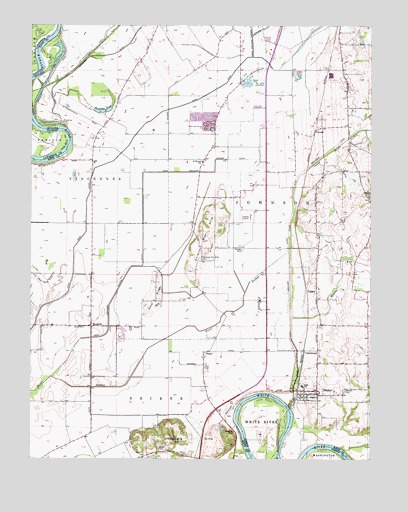
Decker, IN USGS Topographic Map
Click on map above to begin viewing in our Map Viewer.

This topographic map contains these locations and features:
Feature Name Type Latitude Longitude GNIS ID View Map
BandmillPopulated PlaceN38.5384°W87.6028°430471View Map
Bandmill FieldAirportN38.5351°W87.5888°2677010View Map
Bedell CemeteryCemeteryN38.5200°W87.5095°430738View Map
Cane RidgeRidgeN38.5467°W87.5789°432106View Map
CantaloupePopulated PlaceN38.5314°W87.5195°432115View Map
Chimney Pier HillsRangeN38.5642°W87.5603°432477View Map
Chimney Pier Hills CemeteryCemeteryN38.5573°W87.5620°432478View Map
DeckerPopulated PlaceN38.5189°W87.5231°433402View Map
Dick CemeteryCemeteryN38.5266°W87.5611°433533View Map
Dicksburg HillsRangeN38.5067°W87.5686°433541View Map
Eke Drainage System DitchCanalN38.6203°W87.5439°434056View Map
Horseshoe PondLakeN38.6005°W87.5969°436498View Map
Johnson Township Volunteer Fire DepartmentBuildingN38.5355°W87.5841°2625625View Map
Johnson Township Volunteer Fire DepartmentBuildingN38.5196°W87.5265°2626513View Map
King BendBendN38.5903°W87.6125°411483View Map
Mantle DitchCanalN38.6237°W87.5409°438538View Map
Muddy RunStreamN38.5406°W87.5289°439858View Map
Plass DitchStreamN38.5153°W87.5306°441227View Map
PurcellPopulated PlaceN38.5956°W87.5192°449714View Map
Saint Peters CemeteryCemeteryN38.5756°W87.5002°442803View Map
Saint Peters Lutheran SchoolSchoolN38.5762°W87.5006°442819View Map
Saint ThomasPopulated PlaceN38.5862°W87.5622°446740View Map
Saint Thomas PitMineN38.5994°W87.5622°2649694View Map
Saint Thomas SchoolSchoolN38.5859°W87.5622°442850View Map
SissonPopulated PlaceN38.5306°W87.5614°443555View Map
Stuart CemeteryCemeteryN38.5012°W87.5675°444281View Map
Swan Pond DitchCanalN38.5989°W87.5789°444462View Map
Town of DeckerCivilN38.5184°W87.5240°2396684View Map
Township of JohnsonCivilN38.5703°W87.5112°453513View Map
Ueding Airport (historical)AirportN38.5692°W87.5484°449370View Map
Upper River DesheeStreamN38.5834°W87.5236°445170View Map
Vieke Drainage System DitchCanalN38.5462°W87.5950°445282View Map
VollmerPopulated PlaceN38.5475°W87.5200°445317View Map
Warth CemeteryCemeteryN38.5024°W87.5776°445489View Map

Note: Coordinates in the location and feature list above are referenced to NAD83 datum.


Copyright (C) 2008-2025 Ryan Niemi / Sunset Dynamics ... All Rights Reserved