TopoQuest Logo
Do you find TopoQuest useful?
Help keep TopoQuest running and adding new maps/features by donating!
Bitcoin:  19c7KJd3qBynnjoSw5npx9KScwjBe4ifkT
Litecoin:  LXs6TkuXGGXo1vDsWCkWVdjQX94eUKd6ui
Home View Maps Find Maps Find Places Resources & Links


East Mount Carmel, Indiana Topographic Map

USGS Map Title: East Mount Carmel, IN
USGS Map MRC: 38087D6
DRG (GeoTIFF) Download: o38087d6.tif


Neighboring USGS Topographic Map Quads:


  Lancaster, IL  
38087E7
 

  Saint Francisville, IL  
38087E6
 

  Decker, IN  
38087E5
 

  Mount Carmel, IL  
38087D7
 

  East Mount Carmel, IN  
38087D6
 

  Patoka, IN  
38087D5
 

  Keensburg, IL  
38087C7
 

  Owensville, IN  
38087C6
 

  Princeton, IN  
38087C5


Map MRC Location:

N39°
W88°
N39°
W87°
H8 H7 H6 H5 H4 H3 H2 H1
G8 G7 G6 G5 G4 G3 G2 G1
F8 F7 F6 F5 F4 F3 F2 F1
E8 E7 E6 E5 E4 E3 E2 E1
D8 D7 D6 D5 D4 D3 D2 D1
C8 C7 C6 C5 C4 C3 C2 C1
B8 B7 B6 B5 B4 B3 B2 B1
A8 A7 A6 A5 A4 A3 A2 A1
N38°
W88°
N38°
W87°

East Mount Carmel, IN USGS 1:24K Topographic Map Preview:
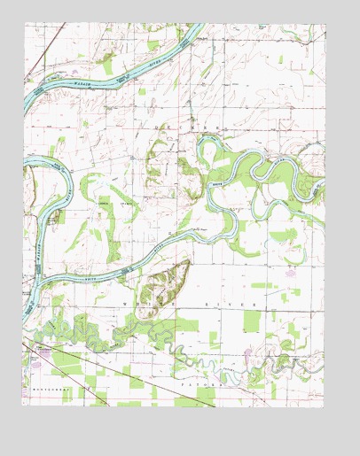
East Mount Carmel, IN USGS Topographic Map
Click on map above to begin viewing in our Map Viewer.

This topographic map contains these locations and features:
Feature Name Type Latitude Longitude GNIS ID View Map
Claypole PondLakeN38.4626°W87.6750°432595View Map
Cypress SwampsSwampN38.4375°W87.7134°433279View Map
East Mount CarmelPopulated PlaceN38.3934°W87.7448°433922View Map
Eickholtz AirportAirportN38.4609°W87.6444°2677048View Map
Gordon HillsRangeN38.4142°W87.6903°435220View Map
Grand RapidsRapidsN38.4353°W87.7411°435298View Map
Hanging RockCliffN38.4534°W87.7484°409742View Map
Hull DitchCanalN38.4073°W87.6606°436598View Map
Kellys RippleRapidsN38.4320°W87.6806°437230View Map
Little RockPopulated PlaceN38.4948°W87.6792°438132View Map
Long PondLakeN38.4413°W87.6472°438278View Map
Maucks PondLakeN38.3894°W87.7470°438738View Map
Mount Carmel FerryLocaleN38.4164°W87.7445°413947View Map
OrrvillePopulated PlaceN38.4581°W87.6861°440706View Map
Orrville CemeteryCemeteryN38.4687°W87.6806°440707View Map
Orrville HillsRangeN38.4556°W87.6889°440708View Map
Pohaten (historical)Populated PlaceN38.4373°W87.7470°1823675View Map
Scott Chapel CemeteryCemeteryN38.4723°W87.7156°443143View Map
Selma (historical)Populated PlaceN38.4259°W87.7481°1823676View Map
Township of DeckerCivilN38.4785°W87.6459°453256View Map
White RiverStreamN38.4142°W87.7425°445955View Map

Note: Coordinates in the location and feature list above are referenced to NAD83 datum.


Copyright (C) 2008-2025 Ryan Niemi / Sunset Dynamics ... All Rights Reserved