TopoQuest Logo
Do you find TopoQuest useful?
Help keep TopoQuest running and adding new maps/features by donating!
Bitcoin:  19c7KJd3qBynnjoSw5npx9KScwjBe4ifkT
Litecoin:  LXs6TkuXGGXo1vDsWCkWVdjQX94eUKd6ui
Home View Maps Find Maps Find Places Resources & Links


Deersville, Ohio Topographic Map

USGS Map Title: Deersville, OH
USGS Map MRC: 40081C2
DRG (GeoTIFF) Download: o40081c2.tif


Neighboring USGS Topographic Map Quads:


  Uhrichsville, OH  
40081D3
 

  Bowerston, OH  
40081D2
 

  Scio, OH  
40081D1
 

  Tippecanoe, OH  
40081C3
 

  Deersville, OH  
40081C2
 

  Jewett, OH  
40081C1
 

  Freeport, OH  
40081B3
 

  Piedmont, OH  
40081B2
 

  Flushing, OH  
40081B1


Map MRC Location:

N41°
W82°
N41°
W81°
H8 H7 H6 H5 H4 H3 H2 H1
G8 G7 G6 G5 G4 G3 G2 G1
F8 F7 F6 F5 F4 F3 F2 F1
E8 E7 E6 E5 E4 E3 E2 E1
D8 D7 D6 D5 D4 D3 D2 D1
C8 C7 C6 C5 C4 C3 C2 C1
B8 B7 B6 B5 B4 B3 B2 B1
A8 A7 A6 A5 A4 A3 A2 A1
N40°
W82°
N40°
W81°

Deersville, OH USGS 1:24K Topographic Map Preview:
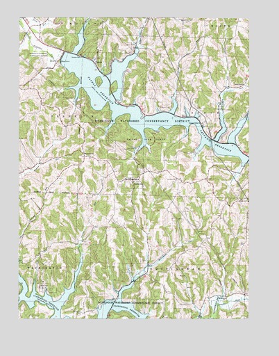
Deersville, OH USGS Topographic Map
Click on map above to begin viewing in our Map Viewer.

This topographic map contains these locations and features:
Feature Name Type Latitude Longitude GNIS ID View Map
Beall BayBayN40.3290°W81.1584°1960605View Map
Beaverdam RunStreamN40.3345°W81.1379°1037773View Map
Beaverdam Run BayBayN40.3298°W81.1387°1960606View Map
Bontrager BayBayN40.3331°W81.1984°1960607View Map
Brownsville ChurchChurchN40.3187°W81.2129°1038393View Map
Brushy Fork BayBayN40.2506°W81.1832°1960608View Map
Clear ForkStreamN40.3334°W81.1259°1039159View Map
Clear Fork BayBayN40.3287°W81.1312°1960609View Map
Clendening (historical)Populated PlaceN40.2526°W81.2140°1062448View Map
Clendening Post Office (historical)Post OfficeN40.2528°W81.2137°1993508View Map
Colman RunStreamN40.2753°W81.2151°1039267View Map
Colman Run BayBayN40.2653°W81.2196°1960610View Map
DeersvillePopulated PlaceN40.3076°W81.1865°1039654View Map
Deersville BayBayN40.2626°W81.1929°1960611View Map
Deersville CemeteryCemeteryN40.3084°W81.1629°1039655View Map
Deersville Community Volunteer Fire Department and Emergency Medical ServicesBuildingN40.3080°W81.1874°2550569View Map
Deersville Methodist Episcopal CemeteryCemeteryN40.3087°W81.1918°1699590View Map
Deersville Post OfficePost OfficeN40.3070°W81.1859°1994139View Map
East Shore Cottage AreaPopulated PlaceN40.3473°W81.1932°1960612View Map
Eddington RunStreamN40.3412°W81.1640°1061047View Map
Edgington Run BayBayN40.3384°W81.1651°1960613View Map
Forty Steuben CampLocaleN40.2526°W81.2151°1048327View Map
Hattonia (historical)Populated PlaceN40.2862°W81.1262°1052093View Map
Hattonia Post OfficePost OfficeN40.2862°W81.1262°1994147View Map
Laceyville (historical)Populated PlaceN40.3223°W81.1318°1061329View Map
Laceyville Post Office (historical)Post OfficeN40.3223°W81.1318°1993540View Map
Leiper RunStreamN40.3448°W81.1370°1065798View Map
Little Colman BayBayN40.2626°W81.2415°1960616View Map
Long PointCapeN40.2592°W81.2448°1960618View Map
Long RunStreamN40.2659°W81.2412°1042755View Map
Lower Beaverdam BayBayN40.3542°W81.1951°1960619View Map
Lower Beaverdam RunStreamN40.3631°W81.1840°1042804View Map
Mathews BayBayN40.3217°W81.1507°1960620View Map
McFadden RunStreamN40.2653°W81.1865°1043102View Map
Minksville CemeteryCemeteryN40.2603°W81.1370°1699599View Map
Minksville ChurchChurchN40.2584°W81.1365°1043403View Map
Mount Hope ChurchChurchN40.3476°W81.1265°1043573View Map
Pleasant Valley (historical)Populated PlaceN40.3306°W81.1507°1080517View Map
Pleasant Valley CemeteryCemeteryN40.3309°W81.1498°1699604View Map
Pleasant Valley ChurchChurchN40.3312°W81.1490°1044602View Map
Plum RunStreamN40.3726°W81.2493°1066902View Map
Smithdale (historical)Populated PlaceN40.3340°W81.1570°1068270View Map
Smithdale Post Office (historical)Post OfficeN40.3487°W81.1568°1993566View Map
TappanPopulated PlaceN40.3573°W81.2076°1063051View Map
Tappan CemeteryCemeteryN40.3581°W81.2076°1699610View Map
Tappan DamDamN40.3584°W81.2262°1077634View Map
Tappan LakeReservoirN40.3324°W81.1705°1046947View Map
Tappan Lake MarinaLocaleN40.3395°W81.1970°1960624View Map
Tappan Lake ParkParkN40.3237°W81.1784°1046946View Map
Tappan Lake Volunteer Fire DepartmentBuildingN40.3405°W81.1965°2550273View Map
Tappan Post Office (historical)Post OfficeN40.3570°W81.2082°1994131View Map
Township of FranklinCivilN40.3352°W81.2276°1086274View Map
Township of NottinghamCivilN40.2646°W81.1637°1086281View Map
Township of StockCivilN40.3326°W81.1278°1086284View Map
Van Horn PondReservoirN40.2851°W81.2215°1079446View Map
Van Horn Pond DamDamN40.2851°W81.2215°1079445View Map
Village of DeersvilleCivilN40.3083°W81.1880°2398708View Map
West Shore Cottage AreaPopulated PlaceN40.3556°W81.2007°1960625View Map
Willis RunStreamN40.3726°W81.2123°1047945View Map
Willis Run BayBayN40.3656°W81.2162°1960626View Map
Wye BayBayN40.3459°W81.2187°1960627View Map
YMCA CampLocaleN40.2628°W81.2371°1048170View Map

Note: Coordinates in the location and feature list above are referenced to NAD83 datum.


Copyright (C) 2008-2025 Ryan Niemi / Sunset Dynamics ... All Rights Reserved