TopoQuest Logo
Do you find TopoQuest useful?
Help keep TopoQuest running and adding new maps/features by donating!
Bitcoin:  19c7KJd3qBynnjoSw5npx9KScwjBe4ifkT
Litecoin:  LXs6TkuXGGXo1vDsWCkWVdjQX94eUKd6ui
Home View Maps Find Maps Find Places Resources & Links


Piedmont, Ohio Topographic Map

USGS Map Title: Piedmont, OH
USGS Map MRC: 40081B2
DRG (GeoTIFF) Download: o40081b2.tif


Neighboring USGS Topographic Map Quads:


  Tippecanoe, OH  
40081C3
 

  Deersville, OH  
40081C2
 

  Jewett, OH  
40081C1
 

  Freeport, OH  
40081B3
 

  Piedmont, OH  
40081B2
 

  Flushing, OH  
40081B1
 

  Antrim, OH  
40081A3
 

  Fairview, OH  
40081A2
 

  Bethesda, OH  
40081A1


Map MRC Location:

N41°
W82°
N41°
W81°
H8 H7 H6 H5 H4 H3 H2 H1
G8 G7 G6 G5 G4 G3 G2 G1
F8 F7 F6 F5 F4 F3 F2 F1
E8 E7 E6 E5 E4 E3 E2 E1
D8 D7 D6 D5 D4 D3 D2 D1
C8 C7 C6 C5 C4 C3 C2 C1
B8 B7 B6 B5 B4 B3 B2 B1
A8 A7 A6 A5 A4 A3 A2 A1
N40°
W82°
N40°
W81°

Piedmont, OH USGS 1:24K Topographic Map Preview:
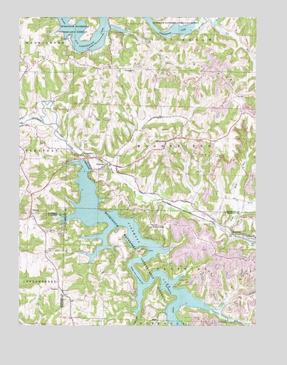
Piedmont, OH USGS Topographic Map
Click on map above to begin viewing in our Map Viewer.

This topographic map contains these locations and features:
Feature Name Type Latitude Longitude GNIS ID View Map
Belmont RidgePopulated PlaceN40.1659°W81.1798°1048517View Map
Belmont Ridge CemeteryCemeteryN40.1653°W81.1798°1699341View Map
Belmont Ridge Methodist Episcopal ChurchChurchN40.1656°W81.1798°1699342View Map
Boggs ForkStreamN40.1945°W81.2137°1066594View Map
Briar Hill ClubLocaleN40.1609°W81.1948°1960584View Map
Briar Hill FarmLocaleN40.1344°W81.2181°2704739View Map
Camp PresmontLocaleN40.1559°W81.1868°1038740View Map
Clendening LakeReservoirN40.2381°W81.2181°1085458View Map
East PiedmontPopulated PlaceN40.1895°W81.1984°1062463View Map
Elk RunStreamN40.2476°W81.1465°1040132View Map
Essex BayBayN40.1603°W81.2048°1960585View Map
Essex CoveBayN40.1537°W81.2140°1960586View Map
GoldaPopulated PlaceN40.1276°W81.1765°1048791View Map
Golda Post Office (historical)Post OfficeN40.1278°W81.1762°1959440View Map
Goodrich Cottage AreaPopulated PlaceN40.1584°W81.1929°1960587View Map
Harrison County ClubLocaleN40.1626°W81.1848°1960588View Map
Hazelwood Hill ClubLocaleN40.1565°W81.1734°1960589View Map
Hidden Ledges Cottage AreaPopulated PlaceN40.1690°W81.1915°1960590View Map
Hilltop Cottage AreaPopulated PlaceN40.1703°W81.1965°1960591View Map
HollowayPopulated PlaceN40.1623°W81.1326°1048847View Map
Holloway Elementary School (historical)SchoolN40.1617°W81.1262°1070101View Map
Holloway Post OfficePost OfficeN40.1626°W81.1332°1959460View Map
Holloway Volunteer Fire Department Station 26BuildingN40.1620°W81.1345°2550553View Map
Huff BayBayN40.2453°W81.1982°1960615View Map
Huff RunStreamN40.2437°W81.1923°1041855View Map
Indian RunStreamN40.1298°W81.1865°1041971View Map
LoghavenPopulated PlaceN40.1606°W81.1812°1960592View Map
MoorefieldPopulated PlaceN40.1998°W81.1709°1065051View Map
Moorefield Methodist Episcopal CemeteryCemeteryN40.2023°W81.1687°1699600View Map
Moorefield Post OfficePost OfficeN40.2001°W81.1707°1994143View Map
Moorefield Township Fire DepartmentBuildingN40.1888°W81.2078°2550266View Map
Muskie BayBayN40.2498°W81.2234°1960622View Map
Oak Grove CemeteryCemeteryN40.1376°W81.2251°1699396View Map
Oak Grove Methodist Episcopal ChurchChurchN40.1384°W81.2265°1699397View Map
OakgrovePopulated PlaceN40.1406°W81.2284°1065184View Map
Oakgrove Post Office (historical)Post OfficeN40.1403°W81.2290°1988917View Map
PiedmontPopulated PlaceN40.1884°W81.1965°1061813View Map
Piedmont DamDamN40.1898°W81.2132°1044426View Map
Piedmont LakeLakeN40.1387°W81.1868°1037285View Map
Piedmont Lake MarinaLocaleN40.1665°W81.2257°1960593View Map
Piedmont Post OfficePost OfficeN40.1890°W81.1971°1994151View Map
Plum RunStreamN40.1906°W81.2032°1044644View Map
Prospect HillSummitN40.2287°W81.1937°1049105View Map
Quaker CemeteryCemeteryN40.1553°W81.2345°1044810View Map
Reynolds Road Cottage AreaPopulated PlaceN40.1290°W81.1729°1960594View Map
Rush RunStreamN40.1728°W81.1334°1045274View Map
Shanty BayBayN40.2498°W81.2321°1960623View Map
Sixmile RunStreamN40.1320°W81.1479°1066206View Map
SmyrnaPopulated PlaceN40.1717°W81.2437°1049184View Map
Smyrna Methodist Episcopal CemeteryCemeteryN40.1706°W81.2448°1699609View Map
Smyrna Post Office (historical)Post OfficeN40.1723°W81.2443°1993567View Map
Stillwater CemeteryCemeteryN40.1431°W81.1601°1046696View Map
Township of FlushingCivilN40.1473°W81.1316°1085777View Map
Township of MoorefieldCivilN40.1996°W81.1580°1086279View Map
Trail RunStreamN40.1676°W81.1462°1047129View Map
Village of HollowayCivilN40.1621°W81.1313°2398527View Map

Note: Coordinates in the location and feature list above are referenced to NAD83 datum.


Copyright (C) 2008-2025 Ryan Niemi / Sunset Dynamics ... All Rights Reserved