TopoQuest Logo
Do you find TopoQuest useful?
Help keep TopoQuest running and adding new maps/features by donating!
Bitcoin:  19c7KJd3qBynnjoSw5npx9KScwjBe4ifkT
Litecoin:  LXs6TkuXGGXo1vDsWCkWVdjQX94eUKd6ui
Home View Maps Find Maps Find Places Resources & Links


Tippecanoe, Ohio Topographic Map

USGS Map Title: Tippecanoe, OH
USGS Map MRC: 40081C3
DRG (GeoTIFF) Download: o40081c3.tif


Neighboring USGS Topographic Map Quads:


  New Philadelphia, OH  
40081D4
 

  Uhrichsville, OH  
40081D3
 

  Bowerston, OH  
40081D2
 

  Gnadenhutten, OH  
40081C4
 

  Tippecanoe, OH  
40081C3
 

  Deersville, OH  
40081C2
 

  Birmingham, OH  
40081B4
 

  Freeport, OH  
40081B3
 

  Piedmont, OH  
40081B2


Map MRC Location:

N41°
W82°
N41°
W81°
H8 H7 H6 H5 H4 H3 H2 H1
G8 G7 G6 G5 G4 G3 G2 G1
F8 F7 F6 F5 F4 F3 F2 F1
E8 E7 E6 E5 E4 E3 E2 E1
D8 D7 D6 D5 D4 D3 D2 D1
C8 C7 C6 C5 C4 C3 C2 C1
B8 B7 B6 B5 B4 B3 B2 B1
A8 A7 A6 A5 A4 A3 A2 A1
N40°
W82°
N40°
W81°

Tippecanoe, OH USGS 1:24K Topographic Map Preview:
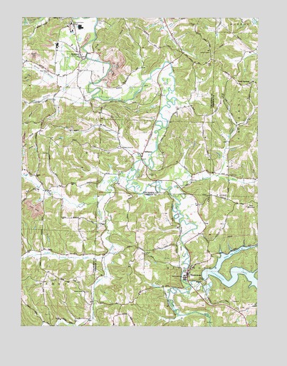
Tippecanoe, OH USGS Topographic Map
Click on map above to begin viewing in our Map Viewer.

This topographic map contains these locations and features:
Feature Name Type Latitude Longitude GNIS ID View Map
Blizzard School (historical)SchoolN40.3287°W81.3657°1054384View Map
Brushy ForkStreamN40.2670°W81.2846°1066610View Map
Chapel CemeteryCemeteryN40.3111°W81.2649°1038990View Map
Clendening DamDamN40.2694°W81.2766°1080469View Map
Crooked CreekStreamN40.3109°W81.3148°1066666View Map
Crooked Creek MineMineN40.3037°W81.3226°1731288View Map
Dutch ValleyValleyN40.3520°W81.3562°1080426View Map
Dutch Valley CemeteryCemeteryN40.3529°W81.3610°1039908View Map
Dutch Valley School (historical)SchoolN40.3576°W81.3698°1054383View Map
Fallen Timber CreekStreamN40.2781°W81.3309°1040376View Map
Feed Spring CemeteryCemeteryN40.3481°W81.2543°1700886View Map
Feed Spring ChurchChurchN40.3484°W81.2543°1700887View Map
Feed Spring Post Office (historical)Post OfficeN40.3487°W81.2526°1993518View Map
Feed SpringsPopulated PlaceN40.3492°W81.2532°1064645View Map
Hefling BayBayN40.2795°W81.2643°1960614View Map
Hefling RunStreamN40.2820°W81.2532°1041462View Map
Hillside School (historical)SchoolN40.3159°W81.2932°1054382View Map
Hillview Baptist ChurchChurchN40.3745°W81.3546°1080399View Map
Hitchcock MineMineN40.3301°W81.2682°1731303View Map
Hitchcock RunStreamN40.3115°W81.2712°1041624View Map
Latto School (historical)SchoolN40.3526°W81.2837°1054380View Map
Laurel CreekStreamN40.3084°W81.3262°1066793View Map
Lima ChurchChurchN40.3115°W81.3068°1042568View Map
Lima Church CemeteryCemeteryN40.3114°W81.3068°1963834View Map
Lindon Family CemeteryCemeteryN40.2548°W81.3601°1963835View Map
Log Cabin BayBayN40.2667°W81.2532°1960617View Map
Mayes CemeteryCemeteryN40.2796°W81.3088°1043071View Map
Mays School (historical)SchoolN40.2812°W81.3098°1052090View Map
McConnell BayBayN40.2726°W81.2507°1960621View Map
Moore School (historical)SchoolN40.3703°W81.2721°1052092View Map
Mount Carmel CemeteryCemeteryN40.2639°W81.3409°1963839View Map
Mount Carmel ChurchChurchN40.2637°W81.3421°1043554View Map
NewportPopulated PlaceN40.3592°W81.3429°1065148View Map
Newport Methodist CemeteryCemeteryN40.3592°W81.3448°1080398View Map
Newport Methodist ChurchChurchN40.3592°W81.3434°1080397View Map
Pleasant Grove CemeteryCemeteryN40.3220°W81.3223°1963844View Map
Pleasant Grove ChurchChurchN40.3223°W81.3218°1057928View Map
RockPopulated PlaceN40.3051°W81.3621°1062985View Map
Rock Post Office (historical)Post OfficeN40.3056°W81.3623°2062084View Map
Ross School (historical)SchoolN40.3698°W81.3179°1054381View Map
RushPopulated PlaceN40.3106°W81.3679°1065257View Map
Rush Community CemeteryCemeteryN40.3109°W81.3687°1080396View Map
Rush Community ChurchChurchN40.3115°W81.3684°1080395View Map
Rush Post Office (historical)Post OfficeN40.3112°W81.3679°2062502View Map
StillwaterPopulated PlaceN40.3234°W81.3084°1065384View Map
TippecanoePopulated PlaceN40.2698°W81.2868°1061693View Map
Tippecanoe Census Designated PlaceCensusN40.2738°W81.2811°2628978View Map
Tippecanoe Elementary SchoolSchoolN40.2748°W81.2848°1063519View Map
Tippecanoe MineMineN40.2820°W81.2957°1731326View Map
Tippecanoe Post OfficePost OfficeN40.2695°W81.2873°1994150View Map
Toad HollowValleyN40.3434°W81.3534°1047077View Map
Township of RushCivilN40.3228°W81.3657°1087063View Map
Township of WashingtonCivilN40.2660°W81.2780°1086285View Map
Utterback HollowValleyN40.3317°W81.2612°1047389View Map
Washington Township Volunteer Fire and First RespondersBuildingN40.2749°W81.2847°1080394View Map
Watson CreekStreamN40.3109°W81.3743°1067040View Map
Watson School (historical)SchoolN40.2695°W81.3551°1054385View Map
Weaver RunStreamN40.3026°W81.2934°1058111View Map
Weaver School (historical)SchoolN40.3101°W81.2604°1052091View Map
Wills MountainSummitN40.2995°W81.2534°1067593View Map

Note: Coordinates in the location and feature list above are referenced to NAD83 datum.


Copyright (C) 2008-2025 Ryan Niemi / Sunset Dynamics ... All Rights Reserved