TopoQuest Logo
Do you find TopoQuest useful?
Help keep TopoQuest running and adding new maps/features by donating!
Bitcoin:  19c7KJd3qBynnjoSw5npx9KScwjBe4ifkT
Litecoin:  LXs6TkuXGGXo1vDsWCkWVdjQX94eUKd6ui
Home View Maps Find Maps Find Places Resources & Links


Freeport, Ohio Topographic Map

USGS Map Title: Freeport, OH
USGS Map MRC: 40081B3
DRG (GeoTIFF) Download: o40081b3.tif


Neighboring USGS Topographic Map Quads:


  Gnadenhutten, OH  
40081C4
 

  Tippecanoe, OH  
40081C3
 

  Deersville, OH  
40081C2
 

  Birmingham, OH  
40081B4
 

  Freeport, OH  
40081B3
 

  Piedmont, OH  
40081B2
 

  Old Washington, OH  
40081A4
 

  Antrim, OH  
40081A3
 

  Fairview, OH  
40081A2


Map MRC Location:

N41°
W82°
N41°
W81°
H8 H7 H6 H5 H4 H3 H2 H1
G8 G7 G6 G5 G4 G3 G2 G1
F8 F7 F6 F5 F4 F3 F2 F1
E8 E7 E6 E5 E4 E3 E2 E1
D8 D7 D6 D5 D4 D3 D2 D1
C8 C7 C6 C5 C4 C3 C2 C1
B8 B7 B6 B5 B4 B3 B2 B1
A8 A7 A6 A5 A4 A3 A2 A1
N40°
W82°
N40°
W81°

Freeport, OH USGS 1:24K Topographic Map Preview:
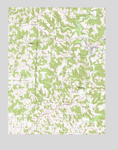
Freeport, OH USGS Topographic Map
Click on map above to begin viewing in our Map Viewer.

This topographic map contains these locations and features:
Feature Name Type Latitude Longitude GNIS ID View Map
Atkinson CreekStreamN40.2290°W81.2826°1066552View Map
Bearman RunStreamN40.2203°W81.2790°1067743View Map
Beech Grove School (historical)SchoolN40.1951°W81.3657°1054663View Map
Chestnut Hill School (historical)SchoolN40.1648°W81.3690°1054664View Map
Chestnut Hill United Brethren CemeteryCemeteryN40.1831°W81.3584°1963714View Map
Chestnut Hill United Brethren ChurchChurchN40.1834°W81.3576°1039045View Map
Crab Orchard MineMineN40.2015°W81.2684°1731287View Map
Craborchard CreekStreamN40.2181°W81.2782°1066665View Map
Craborchard School (historical)SchoolN40.1834°W81.3121°1052103View Map
Dry Ridge School (historical)SchoolN40.1917°W81.2865°1052104View Map
FreeportPopulated PlaceN40.2106°W81.2662°1048760View Map
Freeport Elementary SchoolSchoolN40.2128°W81.2712°1063516View Map
Freeport Methodist CemeteryCemeteryN40.2155°W81.2694°1699594View Map
Freeport Post OfficePost OfficeN40.2112°W81.2665°1994140View Map
Freeport Presbyterian CemeteryCemeteryN40.2101°W81.2637°1699595View Map
Freeport Volunteer Fire and Emergency Medical ServicesBuildingN40.2107°W81.2655°2550217View Map
Friendly Ridge School (historical)SchoolN40.2476°W81.3118°1052106View Map
Grapevine School (historical)SchoolN40.1348°W81.3718°1054665View Map
Greenmont CemeteryCemeteryN40.2142°W81.2582°1041148View Map
Hidden Haven LakeReservoirN40.1311°W81.3030°1077688View Map
Hidden Haven Lake DamDamN40.1301°W81.3015°1077687View Map
Jenkins CemeteryCemeteryN40.2410°W81.2560°1042077View Map
Kerr - Boyd CemeteryCemeteryN40.2226°W81.3004°1042241View Map
Lakeland High SchoolSchoolN40.2195°W81.2501°1081527View Map
LondonderryPopulated PlaceN40.1548°W81.3004°1065717View Map
Londonderry Post Office (historical)Post OfficeN40.1542°W81.2998°1989201View Map
Londonderry SchoolSchoolN40.1537°W81.3121°1042724View Map
Mears CemeteryCemeteryN40.2300°W81.3615°1043201View Map
Millers ForkStreamN40.1331°W81.2829°1043377View Map
Pleasant Hill ChurchChurchN40.1926°W81.3482°1963740View Map
Pleasant Hill Methodist Protestant CemeteryCemeteryN40.1926°W81.3476°1963741View Map
Scotch Covenanter CemeteryCemeteryN40.1563°W81.3016°1046047View Map
Skull ForkStreamN40.2020°W81.2726°1066963View Map
Skull Fork BridgeBridgeN40.1828°W81.2690°1052105View Map
Small Atkinson CreekStreamN40.2142°W81.3279°1067592View Map
Sunset View CemeteryCemeteryN40.1503°W81.2984°1046875View Map
Township of FreeportCivilN40.2000°W81.2815°1086275View Map
Township of LondonderryCivilN40.1273°W81.2844°1086184View Map
Upper Craborchard School (historical)SchoolN40.1567°W81.3201°1054662View Map
Village of FreeportCivilN40.2110°W81.2687°2398926View Map
West ChesterPopulated PlaceN40.2337°W81.3443°1070987View Map
Westchester CemeteryCemeteryN40.2284°W81.3465°1963874View Map
Yankee Point CemeteryCemeteryN40.1346°W81.2673°1048176View Map

Note: Coordinates in the location and feature list above are referenced to NAD83 datum.


Copyright (C) 2008-2024 Ryan Niemi / Sunset Dynamics ... All Rights Reserved