TopoQuest Logo
Do you find TopoQuest useful?
Help keep TopoQuest running and adding new maps/features by donating!
Bitcoin:  19c7KJd3qBynnjoSw5npx9KScwjBe4ifkT
Litecoin:  LXs6TkuXGGXo1vDsWCkWVdjQX94eUKd6ui
Home View Maps Find Maps Find Places Resources & Links


Delhi, New York Topographic Map

USGS Map Title: Delhi, NY
USGS Map MRC: 42074C8
DRG (GeoTIFF) Download: o42074c8.tif


Neighboring USGS Topographic Map Quads:


  Oneonta, NY  
42075D1
 

  West Davenport, NY  
42074D8
 

  Davenport, NY  
42074D7
 

  Treadwell, NY  
42075C1
 

  Delhi, NY  
42074C8
 

  Bloomville, NY  
42074C7
 

  Walton East, NY  
42075B1
 

  Hamden, NY  
42074B8
 

  Andes, NY  
42074B7


Map MRC Location:

N43°
W75°
N43°
W74°
H8 H7 H6 H5 H4 H3 H2 H1
G8 G7 G6 G5 G4 G3 G2 G1
F8 F7 F6 F5 F4 F3 F2 F1
E8 E7 E6 E5 E4 E3 E2 E1
D8 D7 D6 D5 D4 D3 D2 D1
C8 C7 C6 C5 C4 C3 C2 C1
B8 B7 B6 B5 B4 B3 B2 B1
A8 A7 A6 A5 A4 A3 A2 A1
N42°
W75°
N42°
W74°

Delhi, NY USGS 1:24K Topographic Map Preview:
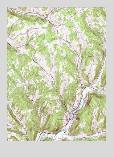
Delhi, NY USGS Topographic Map
Click on map above to begin viewing in our Map Viewer.

This topographic map contains these locations and features:
Feature Name Type Latitude Longitude GNIS ID View Map
Alumni HallBuildingN42.2708°W74.9244°2508047View Map
Betty Acres Organic FarmLocaleN42.2589°W74.8806°2560262View Map
Big TomSummitN42.3284°W74.8954°943961View Map
Bush HallBuildingN42.2703°W74.9236°2508035View Map
Cannon Free LibraryBuildingN42.2746°W74.9186°2617239View Map
Christian Church Cemetery at Fitch's BridgeCemeteryN42.2989°W74.8787°2508028View Map
Delaware Academy and Central SchoolSchoolN42.2720°W74.9146°948264View Map
Delaware County Countryside Care CenterBuildingN42.2577°W74.9459°2614625View Map
DelhiPopulated PlaceN42.2781°W74.9160°948275View Map
Delhi Alliance FellowshipChurchN42.2970°W74.9126°2615840View Map
Delhi College Golf CourseLocaleN42.2539°W74.9258°2508022View Map
Delhi Community ParkParkN42.2817°W74.9075°2508024View Map
Delhi Elementary SchoolSchoolN42.2700°W74.9127°2668830View Map
Delhi Middle SchoolSchoolN42.2714°W74.9138°2669153View Map
Delhi Post OfficePost OfficeN42.2778°W74.9176°2617885View Map
Delhi ReservoirReservoirN42.2890°W74.9311°948276View Map
Delhi Volunteer Fire Department Station 1BuildingN42.2869°W74.9124°2735060View Map
DuBois HallBuildingN42.2714°W74.9239°2508040View Map
East DelhiPopulated PlaceN42.2990°W74.8788°949058View Map
East Delhi Christian ChurchChurchN42.2989°W74.8786°2508027View Map
East Platner BrookStreamN42.2554°W74.9763°949207View Map
Elk CreekStreamN42.2984°W74.8943°949491View Map
Evenden TowerBuildingN42.2697°W74.9236°2508036View Map
Falls CreekStreamN42.2990°W74.9015°949892View Map
Farnsworth HallBuildingN42.2694°W74.9244°2508039View Map
Farrell HallBuildingN42.2697°W74.9244°2508049View Map
Federal HillSummitN42.2881°W74.8835°949953View Map
First Presbyterian ChurchChurchN42.2744°W74.9219°2508018View Map
Fitches BridgeLocaleN42.2981°W74.8793°950187View Map
Fitches Covered BridgeBridgeN42.2983°W74.8792°2097326View Map
Flats CemeteryCemeteryN42.2526°W74.9277°959316View Map
Gerry HallBuildingN42.2714°W74.9247°2508046View Map
Hollister HillSummitN42.3120°W74.9013°953001View Map
Honest BrookStreamN42.3134°W74.9099°953137View Map
Hughes BrookStreamN42.2584°W74.8754°953406View Map
Immanuel Lutheran ChurchChurchN42.2670°W74.9161°2616522View Map
Kunsela HallBuildingN42.2703°W74.9244°2508048View Map
Leisure Village Mobile Home ParkPopulated PlaceN42.3036°W74.9081°2618252View Map
Little Delaware RiverStreamN42.2598°W74.9285°955512View Map
MacDonald HallBuildingN42.2725°W74.9247°2508043View Map
Mason AirwayAirportN42.3256°W74.9865°2443141View Map
MeredithPopulated PlaceN42.3584°W74.9343°956980View Map
Meredith Baptist ChurchChurchN42.3592°W74.9322°2508023View Map
Meredith Hollow CemeteryCemeteryN42.3698°W74.9634°2508031View Map
Meredith Square CemeteryCemeteryN42.3601°W74.9332°2508025View Map
MeridalePopulated PlaceN42.3670°W74.9538°956982View Map
Meridale Fire DepartmentBuildingN42.3669°W74.9526°2718591View Map
Mount MeredithSummitN42.3545°W74.9438°956981View Map
Murphy HallBuildingN42.2722°W74.9244°2508042View Map
North HallBuildingN42.2722°W74.9233°2508041View Map
O'Connor HallBuildingN42.2731°W74.9247°2508044View Map
O'Connor HospitalHospitalN42.2684°W74.9165°2614560View Map
Peaks BrookStreamN42.2565°W74.9541°960049View Map
Pine Grove CemeteryCemeteryN42.3680°W74.9496°960443View Map
Post CemeteryCemeteryN42.3023°W74.9789°961009View Map
Rattail RidgeRidgeN42.3665°W74.8785°962211View Map
Russell HallBuildingN42.2725°W74.9256°2508045View Map
Saint John's ChurchChurchN42.2786°W74.9156°2508019View Map
Saint Peter's ChurchChurchN42.2756°W74.9214°2508020View Map
Sanford Hall Computer Technology CenterBuildingN42.2689°W74.9236°2508037View Map
School Number 10 (historical)SchoolN42.2787°W74.9585°974930View Map
School Number 11 (historical)SchoolN42.3642°W74.9529°974968View Map
School Number 17 (historical)SchoolN42.2695°W74.9843°975133View Map
School Number 5 (historical)SchoolN42.3401°W74.9785°975393View Map
Slope FarmsLocaleN42.3142°W74.9428°2560289View Map
Smith HallBuildingN42.2681°W74.9244°2508038View Map
South HallBuildingN42.2686°W74.9231°2508034View Map
Spring LakeLakeN42.3256°W74.9644°966074View Map
State University of New York at DelhiSchoolN42.2708°W74.9239°2508032View Map
Steele BrookStreamN42.2718°W74.9179°966323View Map
Tabernacle of the CongregationChurchN42.2750°W74.9513°2616304View Map
The Church of Jesus Christ of Latter Day SaintsChurchN42.2854°W74.9127°2616322View Map
Thurston HallBuildingN42.2694°W74.9228°2508033View Map
Toll Gate BrookStreamN42.2540°W74.8890°967599View Map
Town of DelhiCivilN42.2739°W74.9095°978895View Map
Town of MeredithCivilN42.3647°W74.9435°979210View Map
United Ministry of DelhiChurchN42.2783°W74.9164°2508021View Map
Village of DelhiCivilN42.2786°W74.9150°2391637View Map
Watauga FallsFallsN42.3004°W74.9057°968882View Map
West Branch Delaware River BridgeBridgeN42.2750°W74.9164°2615002View Map
West Platner BrookStreamN42.2554°W74.9763°970840View Map
West Platner Brook School (historical)SchoolN42.2679°W74.9999°970841View Map
West Wind FarmLocaleN42.3636°W74.8964°2557741View Map
Woodland CemeteryCemeteryN42.2821°W74.9156°971651View Map

Note: Coordinates in the location and feature list above are referenced to NAD83 datum.


Copyright (C) 2008-2024 Ryan Niemi / Sunset Dynamics ... All Rights Reserved