TopoQuest Logo
Do you find TopoQuest useful?
Help keep TopoQuest running and adding new maps/features by donating!
Bitcoin:  19c7KJd3qBynnjoSw5npx9KScwjBe4ifkT
Litecoin:  LXs6TkuXGGXo1vDsWCkWVdjQX94eUKd6ui
Home View Maps Find Maps Find Places Resources & Links


West Davenport, New York Topographic Map

USGS Map Title: West Davenport, NY
USGS Map MRC: 42074D8
DRG (GeoTIFF) Download: o42074d8.tif


Neighboring USGS Topographic Map Quads:


  Mount Vision, NY  
42075E1
 

  Milford, NY  
42074E8
 

  Schenevus, NY  
42074E7
 

  Oneonta, NY  
42075D1
 

  West Davenport, NY  
42074D8
 

  Davenport, NY  
42074D7
 

  Treadwell, NY  
42075C1
 

  Delhi, NY  
42074C8
 

  Bloomville, NY  
42074C7


Map MRC Location:

N43°
W75°
N43°
W74°
H8 H7 H6 H5 H4 H3 H2 H1
G8 G7 G6 G5 G4 G3 G2 G1
F8 F7 F6 F5 F4 F3 F2 F1
E8 E7 E6 E5 E4 E3 E2 E1
D8 D7 D6 D5 D4 D3 D2 D1
C8 C7 C6 C5 C4 C3 C2 C1
B8 B7 B6 B5 B4 B3 B2 B1
A8 A7 A6 A5 A4 A3 A2 A1
N42°
W75°
N42°
W74°

West Davenport, NY USGS 1:24K Topographic Map Preview:
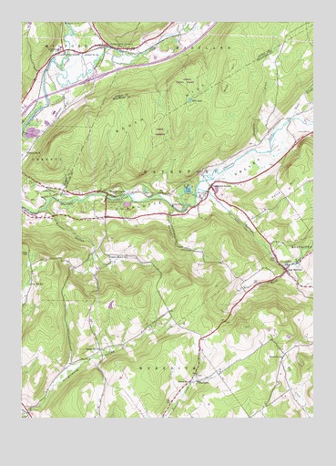
West Davenport, NY USGS Topographic Map
Click on map above to begin viewing in our Map Viewer.

This topographic map contains these locations and features:
Feature Name Type Latitude Longitude GNIS ID View Map
Alcott Trailer ParkPopulated PlaceN42.4553°W74.9169°2618200View Map
Charlotte Valley CemeteryCemeteryN42.4439°W74.9627°946418View Map
Coe Hill SchoolSchoolN42.4173°W74.9960°946994View Map
ColliersvillePopulated PlaceN42.4909°W74.9821°947146View Map
Colliersville Post OfficePost OfficeN42.4909°W74.9829°2598927View Map
Cooperstown JunctionPopulated PlaceN42.4917°W74.9571°947402View Map
Cooperstown Junction CemeteryCemeteryN42.4926°W74.9662°2558764View Map
Cooperstown Medical TransportBuildingN42.4466°W74.9704°2718755View Map
Crawford BrookStreamN42.4631°W74.8932°947716View Map
Davenport CenterPopulated PlaceN42.4481°W74.9190°948049View Map
Davenport Center CemeteryCemeteryN42.4424°W74.9238°2548259View Map
Davenport Center Census Designated PlaceCensusN42.4459°W74.9087°2628044View Map
Dona BrookStreamN42.4698°W74.8832°948565View Map
Dutch HillSummitN42.4459°W74.8893°948852View Map
East MeredithPopulated PlaceN42.4215°W74.8868°949171View Map
East Meredith CemeteryCemeteryN42.4201°W74.8852°2508026View Map
East Meredith Fire DepartmentBuildingN42.4307°W74.8936°2718307View Map
East Meredith Post OfficePost OfficeN42.4226°W74.8864°2617899View Map
East Meredith Presbyterian ChurchChurchN42.4169°W74.8759°2615857View Map
Hanford Mills MuseumBuildingN42.4236°W74.8864°2617507View Map
Houghtaling HollowValleyN42.3773°W74.9965°953280View Map
Kortright CreekStreamN42.4479°W74.9249°954808View Map
McMinn CemeteryCemeteryN42.4461°W74.9473°956834View Map
Mine BrookStreamN42.4237°W74.8877°957379View Map
Mud LakeLakeN42.4755°W74.9274°958022View Map
Newell CemeteryCemeteryN42.4654°W74.8768°958505View Map
Pindars CornersPopulated PlaceN42.4387°W74.9638°974160View Map
Pindars Corners Volunteer Fire DepartmentBuildingN42.4382°W74.9648°2718268View Map
Pine LakeLakeN42.4471°W74.9285°960497View Map
Prosser HollowValleyN42.4409°W74.9896°961200View Map
Prosser Hollow SchoolSchoolN42.4262°W74.9624°961202View Map
Pumpkin HollowValleyN42.4412°W74.9352°961971View Map
Schenevus CreekStreamN42.4854°W74.9832°964575View Map
School Number 12 (historical)SchoolN42.4898°W74.9729°975016View Map
School Number 14 (historical)SchoolN42.4587°W74.9974°975080View Map
School Number 16 (historical)SchoolN42.3859°W74.9277°975117View Map
School Number 17 (historical)SchoolN42.3967°W74.9665°975134View Map
School Number 2 (historical)SchoolN42.4433°W74.9642°2376991View Map
School Number 3 (historical)SchoolN42.4467°W74.9178°2376992View Map
School Number 4 (historical)SchoolN42.3942°W74.8882°975317View Map
ShackportPopulated PlaceN42.3867°W74.9246°973053View Map
Tomahawk Hills AirportAirportN42.4011°W74.8968°978145View Map
Town of DavenportCivilN42.4549°W74.9021°978887View Map
Webb HillSummitN42.4792°W74.9135°968972View Map
West DavenportPopulated PlaceN42.4459°W74.9632°969203View Map
Word of Faith ChurchChurchN42.4929°W74.9477°2597917View Map

Note: Coordinates in the location and feature list above are referenced to NAD83 datum.


Copyright (C) 2008-2025 Ryan Niemi / Sunset Dynamics ... All Rights Reserved