TopoQuest Logo
Do you find TopoQuest useful?
Help keep TopoQuest running and adding new maps/features by donating!
Bitcoin:  19c7KJd3qBynnjoSw5npx9KScwjBe4ifkT
Litecoin:  LXs6TkuXGGXo1vDsWCkWVdjQX94eUKd6ui
Home View Maps Find Maps Find Places Resources & Links


Delphos, Ohio Topographic Map

USGS Map Title: Delphos, OH
USGS Map MRC: 40084G3
DRG (GeoTIFF) Download: o40084g3.tif


Neighboring USGS Topographic Map Quads:


  Wetsel, OH  
40084H4
 

  Ottoville, OH  
40084H3
 

  Kalida, OH  
40084H2
 

  Middle Point, OH  
40084G4
 

  Delphos, OH  
40084G3
 

  Elida, OH  
40084G2
 

  Elgin, OH  
40084F4
 

  Spencerville, OH  
40084F3
 

  Cridersville, OH  
40084F2


Map MRC Location:

N41°
W85°
N41°
W84°
H8 H7 H6 H5 H4 H3 H2 H1
G8 G7 G6 G5 G4 G3 G2 G1
F8 F7 F6 F5 F4 F3 F2 F1
E8 E7 E6 E5 E4 E3 E2 E1
D8 D7 D6 D5 D4 D3 D2 D1
C8 C7 C6 C5 C4 C3 C2 C1
B8 B7 B6 B5 B4 B3 B2 B1
A8 A7 A6 A5 A4 A3 A2 A1
N40°
W85°
N40°
W84°

Delphos, OH USGS 1:24K Topographic Map Preview:
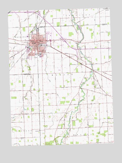
Delphos, OH USGS Topographic Map
Click on map above to begin viewing in our Map Viewer.

This topographic map contains these locations and features:
Feature Name Type Latitude Longitude GNIS ID View Map
City of DelphosCivilN40.8480°W84.3369°2394508View Map
DelphosPopulated PlaceN40.8434°W84.3416°1056973View Map
Delphos Airport (historical)AirportN40.8209°W84.3125°1082653View Map
Delphos City ParkParkN40.8434°W84.3425°1807386View Map
Delphos Fire and RescueBuildingN40.8435°W84.3388°2550204View Map
Delphos Fire and Rescue Vehicle StorageBuildingN40.8350°W84.3382°2549309View Map
Delphos Police DepartmentBuildingN40.8435°W84.3389°2732879View Map
Delphos Post OfficePost OfficeN40.8437°W84.3400°1082343View Map
Delphos QuarryMineN40.8372°W84.3519°2634702View Map
Delphos Water WorksLocaleN40.8353°W84.3377°1807373View Map
Delphos Wesleyan ChurchChurchN40.8342°W84.3513°1062509View Map
Fairview School (historical)SchoolN40.8164°W84.3205°1053371View Map
First Assembly of God ChurchChurchN40.8506°W84.3472°1062510View Map
First Christian Union ChurchChurchN40.8381°W84.3366°1062489View Map
First United Presbyterian ChurchChurchN40.8439°W84.3425°1062511View Map
Ford School (historical)SchoolN40.7870°W84.2813°1053369View Map
Franklin Elementary SchoolSchoolN40.8467°W84.3375°1081328View Map
Garfield SchoolSchoolN40.8345°W84.3438°1040778View Map
Hartshorn CemeteryCemeteryN40.8425°W84.2904°1041381View Map
Holiness Mission (historical)ChurchN40.8339°W84.3500°1807387View Map
Holland CourtPopulated PlaceN40.8342°W84.3317°2651757View Map
Jefferson High SchoolSchoolN40.8509°W84.3516°1053826View Map
Jefferson Middle SchoolSchoolN40.8445°W84.3436°1056358View Map
King CemeteryCemeteryN40.8062°W84.2869°1042263View Map
Lincoln SchoolSchoolN40.8370°W84.3355°1042591View Map
Longs School (historical)SchoolN40.8320°W84.2938°1053370View Map
Marion ChurchChurchN40.7792°W84.3077°1065019View Map
Morris Chapel United Methodist ChurchChurchN40.8114°W84.2850°1065059View Map
Munsaker School (historical)SchoolN40.8428°W84.2816°1053368View Map
Needmore (historical)Populated PlaceN40.7795°W84.3080°1053372View Map
Park Trailer ParkPopulated PlaceN40.8364°W84.3353°2651727View Map
Pigeon RunStreamN40.8123°W84.2752°1044432View Map
Pike CemeteryCemeteryN40.7948°W84.2586°1699318View Map
Pike ChurchChurchN40.7945°W84.2577°1065235View Map
Pohlman FarmsLocaleN40.7806°W84.3272°2582421View Map
Riverview School (historical)SchoolN40.8034°W84.2900°1053367View Map
Rode FarmsLocaleN40.7911°W84.3378°2582422View Map
RushmorePopulated PlaceN40.8742°W84.2533°1045284View Map
Rushmore Post Office (historical)Post OfficeN40.8737°W84.2527°2056204View Map
Saint John the Evangelist Catholic ChurchChurchN40.8434°W84.3363°1062496View Map
Saint Johns Catholic CemeteryCemeteryN40.8453°W84.2891°1699322View Map
Saint Johns CemeteryCemeteryN40.8425°W84.3319°1699323View Map
Saint Johns SchoolSchoolN40.8434°W84.3352°1045548View Map
Saint Peter Evangelical Lutheran ChurchChurchN40.8464°W84.3355°1062499View Map
Scotts CrossingPopulated PlaceN40.8178°W84.2727°1058009View Map
Scotts Crossing Post Office (historical)Post OfficeN40.8181°W84.2722°1957998View Map
SouthworthPopulated PlaceN40.7639°W84.3400°1049197View Map
Southworth Post Office (historical)Post OfficeN40.7639°W84.3402°1958003View Map
Stadium ParkParkN40.8520°W84.3486°1807436View Map
Township of MarionCivilN40.8140°W84.2946°1085695View Map
Trinity United Methodist ChurchChurchN40.8450°W84.3377°1062501View Map
Ulm's Mobile Home Court IPopulated PlaceN40.8325°W84.3500°2651758View Map
Ulm's Mobile Home Court IIPopulated PlaceN40.8328°W84.3417°2651759View Map
Wallehorst School (historical)SchoolN40.8742°W84.3013°1050119View Map
Walnut Grove CemeteryCemeteryN40.8300°W84.2905°1047535View Map
WDOH-FM (Delphos)TowerN40.8320°W84.3530°1085350View Map
West Jennings CreekStreamN40.8737°W84.3397°1058128View Map
West Union CemeteryCemeteryN40.7575°W84.3641°1047806View Map
Westside CemeteryCemeteryN40.8453°W84.3508°1047831View Map
Youngpeter AirportAirportN40.7799°W84.3688°2442518View Map
Zion ChurchChurchN40.7656°W84.2808°1048275View Map

Note: Coordinates in the location and feature list above are referenced to NAD83 datum.


Copyright (C) 2008-2025 Ryan Niemi / Sunset Dynamics ... All Rights Reserved