TopoQuest Logo
Do you find TopoQuest useful?
Help keep TopoQuest running and adding new maps/features by donating!
Bitcoin:  19c7KJd3qBynnjoSw5npx9KScwjBe4ifkT
Litecoin:  LXs6TkuXGGXo1vDsWCkWVdjQX94eUKd6ui
Home View Maps Find Maps Find Places Resources & Links


Denmark, Ohio Topographic Map

USGS Map Title: Denmark, OH
USGS Map MRC: 40082E8
DRG (GeoTIFF) Download: o40082e8.tif


Neighboring USGS Topographic Map Quads:


  Monnett, OH  
40083F1
 

  Caledonia, OH  
40082F8
 

  Galion, OH  
40082F7
 

  Marion East, OH  
40083E1
 

  Denmark, OH  
40082E8
 

  Mount Gilead, OH  
40082E7
 

  Waldo, OH  
40083D1
 

  Ashley, OH  
40082D8
 

  Marengo, OH  
40082D7


Map MRC Location:

N41°
W83°
N41°
W82°
H8 H7 H6 H5 H4 H3 H2 H1
G8 G7 G6 G5 G4 G3 G2 G1
F8 F7 F6 F5 F4 F3 F2 F1
E8 E7 E6 E5 E4 E3 E2 E1
D8 D7 D6 D5 D4 D3 D2 D1
C8 C7 C6 C5 C4 C3 C2 C1
B8 B7 B6 B5 B4 B3 B2 B1
A8 A7 A6 A5 A4 A3 A2 A1
N40°
W83°
N40°
W82°

Denmark, OH USGS 1:24K Topographic Map Preview:
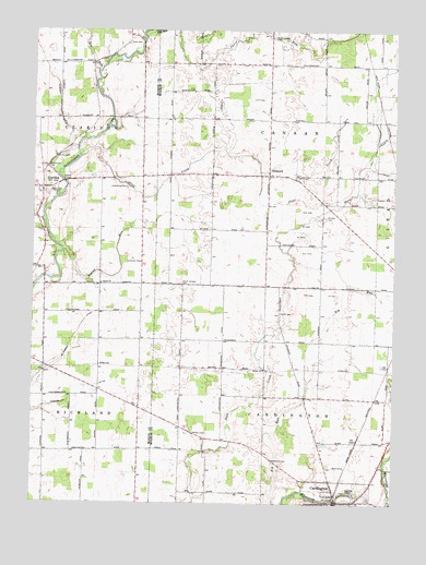
Denmark, OH USGS Topographic Map
Click on map above to begin viewing in our Map Viewer.

This topographic map contains these locations and features:
Feature Name Type Latitude Longitude GNIS ID View Map
Beaver RunStreamN40.5667°W82.9896°1037763View Map
Bee RunStreamN40.6142°W82.9782°1065917View Map
Beech (historical)Populated PlaceN40.5578°W82.9769°1071749View Map
Beech Grove School (historical)SchoolN40.6014°W82.8977°1080676View Map
Bethel CemeteryCemeteryN40.5359°W82.9205°1963203View Map
Bethel ChurchChurchN40.5353°W82.9191°1037936View Map
Bethel School (historical)SchoolN40.5428°W82.9343°1080682View Map
CardingtonPopulated PlaceN40.5006°W82.8935°1056765View Map
Cardington Post OfficePost OfficeN40.5014°W82.8930°2038896View Map
ClaridonPopulated PlaceN40.5831°W82.9969°1056804View Map
Claridon CemeteryCemeteryN40.5826°W82.9932°1960529View Map
Claridon Post Office (historical)Post OfficeN40.5834°W82.9971°2035950View Map
Davis School (historical)SchoolN40.5859°W82.9763°1049604View Map
DenmarkPopulated PlaceN40.5867°W82.9180°1064528View Map
Egypt School (historical)SchoolN40.6009°W82.9935°1049606View Map
Gable School (historical)SchoolN40.5667°W82.9763°1049603View Map
Glendale CemeteryCemeteryN40.5037°W82.8874°1040905View Map
Graveyard HillSummitN40.5953°W82.9913°1960532View Map
Hardscrabble School (historical)SchoolN40.5162°W82.9005°1080679View Map
Hickory Corner School (historical)SchoolN40.5273°W82.9766°1049602View Map
Hinds CemeteryCemeteryN40.5915°W82.9918°1041614View Map
Klinefelter School (historical)SchoolN40.5514°W82.9763°1049608View Map
Long School (historical)SchoolN40.5428°W82.9007°1080678View Map
Lutheran CemeteryCemeteryN40.5637°W82.9624°1071760View Map
McKibben DitchCanalN40.5470°W82.9830°1043121View Map
Muskrat DitchCanalN40.6120°W82.9930°1065789View Map
North Canaan CemeteryCemeteryN40.6231°W82.9171°1043925View Map
Otter CreekStreamN40.5914°W82.9841°1044215View Map
Purvis CemeteryCemeteryN40.5501°W82.9143°1044802View Map
Rainbow Mobile Home ParkPopulated PlaceN40.5031°W82.8833°2514437View Map
Ruehrmond DitchCanalN40.5270°W82.9877°1045251View Map
Russell School (historical)SchoolN40.6153°W82.9619°1049605View Map
Saint Paul Evangelical Lutheran ChurchChurchN40.5003°W82.9016°1074925View Map
Salem CemeteryCemeteryN40.5601°W82.9763°1960542View Map
Salem Evangelical ChurchChurchN40.5581°W82.9763°1045892View Map
Salem School (historical)SchoolN40.5720°W82.9385°1080681View Map
South Canaan CemeteryCemeteryN40.5581°W82.9482°1046452View Map
Thew CemeteryCemeteryN40.6214°W82.9669°1047015View Map
Township of CanaanCivilN40.6044°W82.9142°1086698View Map
Township of CardingtonCivilN40.5199°W82.9138°1086699View Map
Underwood CemeteryCemeteryN40.5834°W82.9674°1072263View Map
West Salem School (historical)SchoolN40.6095°W82.9377°1080680View Map
Weston CemeteryCemeteryN40.5184°W82.9442°1047830View Map
Weston School (historical)SchoolN40.5187°W82.9435°1080683View Map
Williamson CemeteryCemeteryN40.5889°W82.9949°1047937View Map
Wood ValleyPopulated PlaceN40.6189°W82.9772°2513774View Map
Woodlawn CemeteryCemeteryN40.5112°W82.9162°1048087View Map
Worden CemeteryCemeteryN40.5759°W82.8988°1048137View Map
Worden School (historical)SchoolN40.5723°W82.8996°1080677View Map

Note: Coordinates in the location and feature list above are referenced to NAD83 datum.


Copyright (C) 2008-2024 Ryan Niemi / Sunset Dynamics ... All Rights Reserved