TopoQuest Logo
Do you find TopoQuest useful?
Help keep TopoQuest running and adding new maps/features by donating!
Bitcoin:  19c7KJd3qBynnjoSw5npx9KScwjBe4ifkT
Litecoin:  LXs6TkuXGGXo1vDsWCkWVdjQX94eUKd6ui
Home View Maps Find Maps Find Places Resources & Links


Denver, Oklahoma Topographic Map

USGS Map Title: Denver, OK
USGS Map MRC: 35097B3
DRG (GeoTIFF) Download: o35097b3.tif


Neighboring USGS Topographic Map Quads:


  Moore, OK  
35097C4
 

  Franklin, OK  
35097C3
 

  Stella, OK  
35097C2
 

  Norman, OK  
35097B4
 

  Denver, OK  
35097B3
 

  Little Axe, OK  
35097B2
 

  Washington, OK  
35097A4
 

  Purcell, OK  
35097A3
 

  Eason, OK  
35097A2


Map MRC Location:

N36°
W98°
N36°
W97°
H8 H7 H6 H5 H4 H3 H2 H1
G8 G7 G6 G5 G4 G3 G2 G1
F8 F7 F6 F5 F4 F3 F2 F1
E8 E7 E6 E5 E4 E3 E2 E1
D8 D7 D6 D5 D4 D3 D2 D1
C8 C7 C6 C5 C4 C3 C2 C1
B8 B7 B6 B5 B4 B3 B2 B1
A8 A7 A6 A5 A4 A3 A2 A1
N35°
W98°
N35°
W97°

Denver, OK USGS 1:24K Topographic Map Preview:
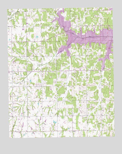
Denver, OK USGS Topographic Map
Click on map above to begin viewing in our Map Viewer.

This topographic map contains these locations and features:
Feature Name Type Latitude Longitude GNIS ID View Map
Adair SchoolSchoolN35.2334°W97.3706°1089527View Map
All Welcome Victory ChurchChurchN35.2323°W97.3173°1801330View Map
City of NobleCivilN35.1386°W97.3710°2411258View Map
City of NormanCivilN35.2335°W97.3470°2411267View Map
Clear CreekStreamN35.2215°W97.2509°1091412View Map
Cleveland CountyCivilN35.2030°W97.3264°1101801View Map
Dave Blue CreekStreamN35.2217°W97.2903°1091939View Map
DenverPopulated PlaceN35.2326°W97.2823°1092049View Map
Denver CemeteryCemeteryN35.2098°W97.2822°1092050View Map
Enterprise Baptist ChurchChurchN35.1878°W97.3181°1799083View Map
Fairview CemeteryCemeteryN35.1387°W97.3003°1092707View Map
Faith Baptist ChurchChurchN35.1737°W97.2648°1801331View Map
Falls CemeteryCemeteryN35.2331°W97.3175°2681378View Map
Falls SchoolSchoolN35.2323°W97.3175°1092758View Map
Fort HillSummitN35.1659°W97.3686°1092964View Map
Independence CemeteryCemeteryN35.1881°W97.3703°1094061View Map
Jim Blue CreekStreamN35.2042°W97.3020°1094223View Map
Liberty ChurchChurchN35.1373°W97.2656°1094610View Map
MaguirePopulated PlaceN35.1312°W97.3000°1100603View Map
Noble High SchoolSchoolN35.1487°W97.3726°1794255View Map
Norman Fire Department Station 6BuildingN35.2200°W97.3299°2658545View Map
Oknoname 02721 DamDamN35.1401°W97.3220°1758665View Map
Oknoname 02721 ReservoirReservoirN35.1397°W97.3210°1758666View Map
Oknoname 02722 DamDamN35.2384°W97.3186°1753081View Map
Oknoname 02723 DamDamN35.2234°W97.3386°1758663View Map
Oknoname 02723 ReservoirReservoirN35.2228°W97.3403°1758664View Map
Pata Skyhaven Airport (historical)AirportN35.1959°W97.3086°1102585View Map
Township of NobleCivilN35.1640°W97.3086°1824748View Map
Washington Elementary SchoolSchoolN35.2148°W97.3712°1099398View Map

Note: Coordinates in the location and feature list above are referenced to NAD83 datum.


Copyright (C) 2008-2024 Ryan Niemi / Sunset Dynamics ... All Rights Reserved